File:Relief Map of Germany, Black Forest.png
Jump to navigation
Jump to search

Size of this preview: 506 × 600 pixels. Other resolutions: 202 × 240 pixels | 405 × 480 pixels | 1,000 × 1,185 pixels.
Original file (1,000 × 1,185 pixels, file size: 1.48 MB, MIME type: image/png)
This is a file from the Wikimedia Commons and may be used by other projects. Information from its description page there is shown below.
Commons is a freely licensed media file repository. |
Summary
| Description |
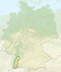
English: Relief map of Germany with outlines of the Black Forest. Equirectangular projection, N/S stretching 150 %. Geographic limits of the map: * N: 55.1° N * S: 47.2° N * W: 5.5° E * E: 15.5° E
Deutsch: Deutschlandkarte mit Umrissen des Schwarzwalds gemäß Naturräumlichen Großregionen Deutschlands nach dem System des Bundesamtes für Naturschutz (BfN). |
| Date | (UTC) |
| Source |
This file was derived from: |
| Author |
|


Licensing
This file is licensed under the Creative Commons Attribution-Share Alike 3.0 Unported license.
- You are free:
- to share – to copy, distribute and transmit the work
- to remix – to adapt the work
- Under the following conditions:
- attribution – You must give appropriate credit, provide a link to the license, and indicate if changes were made. You may do so in any reasonable manner, but not in any way that suggests the licensor endorses you or your use.
- share alike – If you remix, transform, or build upon the material, you must distribute your contributions under the same or compatible license as the original.
Original upload log
This image is a derivative work of the following images:
- File:Relief_Map_of_Germany.png licensed with Cc-by-sa-3.0
- 2010-08-28T17:48:23Z Виктор В 1000x1185 (1796090 Bytes) Рельеф дна
- 2010-08-28T16:40:16Z Виктор В 1000x1185 (1733013 Bytes) мелкие исправления
- 2010-08-28T12:03:54Z Виктор В 1000x1185 (1766531 Bytes) == {{int:filedesc}} == {{Information |Description={{en|Relief map of [[:en:Germany|Germany]]}} [[:en:Equirectangular projection|Equirectangular projection]], N/S stretching 150 %. Geographic limits of the map: * N: 55.1° N *
- File:Deutschland_Naturraeumliche_Grossregionen.png licensed with Cc-by-sa-3.0, GFDL
- 2011-09-29T17:01:59Z NordNordWest 1826x2318 (5659071 Bytes) upd
- 2011-09-22T18:51:25Z NordNordWest 1826x2318 (5641169 Bytes) ergänzt
- 2011-09-14T18:57:42Z NordNordWest 1826x2318 (5615307 Bytes) update
- 2008-06-12T10:16:41Z NordNordWest 1980x2322 (5911072 Bytes)
- 2008-06-12T09:03:16Z NordNordWest 1979x2322 (5753037 Bytes)
- 2008-06-11T19:04:47Z NordNordWest 1979x2321 (5766960 Bytes) == Beschreibung == {{Information |Description= {{de|Karte der [[:de:Naturräumliche Haupteinheiten Deutschlands|Naturräumlichen Haupteinheiten Deutschlands]] nach dem System des [[:de:Bundesamt für Naturschutz|Bundesamtes f
Uploaded with derivativeFX
File history
Click on a date/time to view the file as it appeared at that time.
| Date/Time | Thumbnail | Dimensions | User | Comment | |
|---|---|---|---|---|---|
| current | 02:40, 28 July 2013 | | 1,000 × 1,185 (1.48 MB) | Sitacuisses | == {{int:filedesc}} == {{Information |Description={{en|Relief map of Germany with outlines of the Black Forest. Equirectangular projection, N/S stretching 150 %. Geographic limits ... |
File usage
The following page uses this file:
Global file usage
The following other wikis use this file:
- Usage on af.wikipedia.org
- Usage on arz.wikipedia.org
- Usage on ast.wikipedia.org
- Usage on bh.wikipedia.org
- Usage on bn.wikipedia.org
- Usage on ca.wikipedia.org
- Usage on cs.wikipedia.org
- Usage on da.wikipedia.org
- Usage on de.wikipedia.org
- Usage on en.wikipedia.org
- Usage on eo.wikipedia.org
- Usage on es.wikipedia.org
- Usage on eu.wikipedia.org
- Usage on fa.wikipedia.org
- Usage on fi.wikipedia.org
- Usage on fr.wikipedia.org
- Usage on ga.wikipedia.org
- Usage on he.wikipedia.org
- Usage on it.wikivoyage.org
- Usage on ja.wikipedia.org
- Usage on ka.wikipedia.org
- Usage on ml.wikipedia.org
- Usage on pl.wikipedia.org
- Usage on pl.wikivoyage.org
- Usage on ro.wikipedia.org
- Usage on sco.wikipedia.org
- Usage on sk.wikipedia.org
- Usage on sl.wikipedia.org
- Usage on ta.wikipedia.org
- Usage on th.wikipedia.org
- Usage on tr.wikipedia.org
- Usage on ur.wikipedia.org
- Usage on www.wikidata.org
- Usage on zh.wikipedia.org