File:Slovenský ráj - mapa.svg
Jump to navigation
Jump to search

Size of this PNG preview of this SVG file: 800 × 431 pixels. Other resolutions: 320 × 172 pixels | 640 × 345 pixels | 1,024 × 551 pixels | 1,280 × 689 pixels | 2,560 × 1,378 pixels | 1,300 × 700 pixels.
Original file (SVG file, nominally 1,300 × 700 pixels, file size: 48 KB)
This is a file from the Wikimedia Commons and may be used by other projects. Information from its description page there is shown below.
Commons is a freely licensed media file repository. |
Summary
| Description |
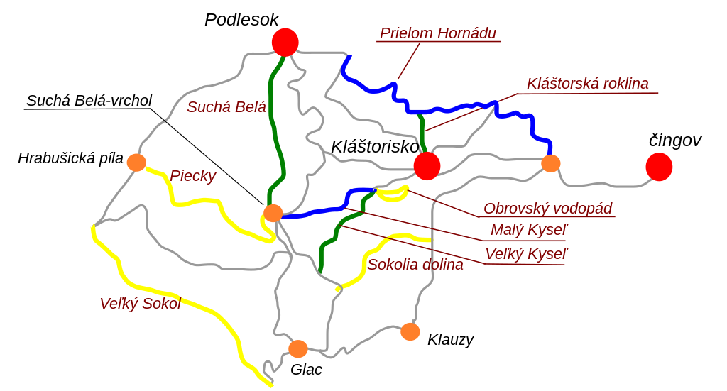
Čeština: Mapa roklin Slovenského raje, Národný park Slovenský raj, Slovensko.
English: Map of the scenic canyons in Slovak Paradise National Park, eastern Slovakia.
|
| Date | 10. 9. 2008 |
| Source | Vlastní práce/ Own work |
| Author | Honza Groh |
| Permission (Reusing this file) |
Při použití fotografie mimo Wikipedie nutno uvést mé jméno/ Photo can be used outside Wikipedia only with my name credited. |
Licensing
I, the copyright holder of this work, hereby publish it under the following licenses:

|
Permission is granted to copy, distribute and/or modify this document under the terms of the GNU Free Documentation License, Version 1.2 or any later version published by the Free Software Foundation; with no Invariant Sections, no Front-Cover Texts, and no Back-Cover Texts. A copy of the license is included in the section entitled GNU Free Documentation License. |
This file is licensed under the Creative Commons Attribution 3.0 Unported license.
- You are free:
- to share – to copy, distribute and transmit the work
- to remix – to adapt the work
- Under the following conditions:
- attribution – You must give appropriate credit, provide a link to the license, and indicate if changes were made. You may do so in any reasonable manner, but not in any way that suggests the licensor endorses you or your use.
You may select the license of your choice.
File history
Click on a date/time to view the file as it appeared at that time.
| Date/Time | Thumbnail | Dimensions | User | Comment | |
|---|---|---|---|---|---|
| current | 20:55, 10 September 2008 | | 1,300 × 700 (48 KB) | Jagro | {{Information |Description= |Source= |Date= |Author= |Permission= |other_versions= }} |
| 20:51, 10 September 2008 |  | 1,300 × 700 (48 KB) | Jagro | {{Information |Description= |Source= |Date= |Author= |Permission= |other_versions= }} | |
| 20:48, 10 September 2008 |  | 1,300 × 700 (42 KB) | Jagro | {{Information |Description={{cs|Mapa roklin Slovenského raje, rokliny jsou zvýrazněny barvou turistické značky, která jimi prohcází, ostatní cesty bez ohledu na TŽ jsou zobrazeny šedě.}} {{en|Map of canyons in Slovak paradaise, canyons are win |
File usage
The following page uses this file:
Global file usage
The following other wikis use this file:
- Usage on az.wikipedia.org
- Usage on cs.wikipedia.org
- Usage on da.wikipedia.org
- Usage on de.wikipedia.org
- Usage on en.wikipedia.org
- Usage on hu.wikipedia.org
- Usage on nn.wikipedia.org
- Usage on sk.wikipedia.org
- Usage on uk.wikipedia.org