File:Spaso-Kamenny Monastery 2013.jpg
Jump to navigation
Jump to search
Size of this preview: 800 × 533 pixels. Other resolutions: 320 × 213 pixels | 640 × 427 pixels | 1,024 × 683 pixels | 1,280 × 853 pixels | 2,757 × 1,838 pixels.
Original file (2,757 × 1,838 pixels, file size: 2.96 MB, MIME type: image/jpeg)
This is a file from the Wikimedia Commons and may be used by other projects. Information from its description page there is shown below.
Commons is a freely licensed media file repository. |
Summary
| Description |
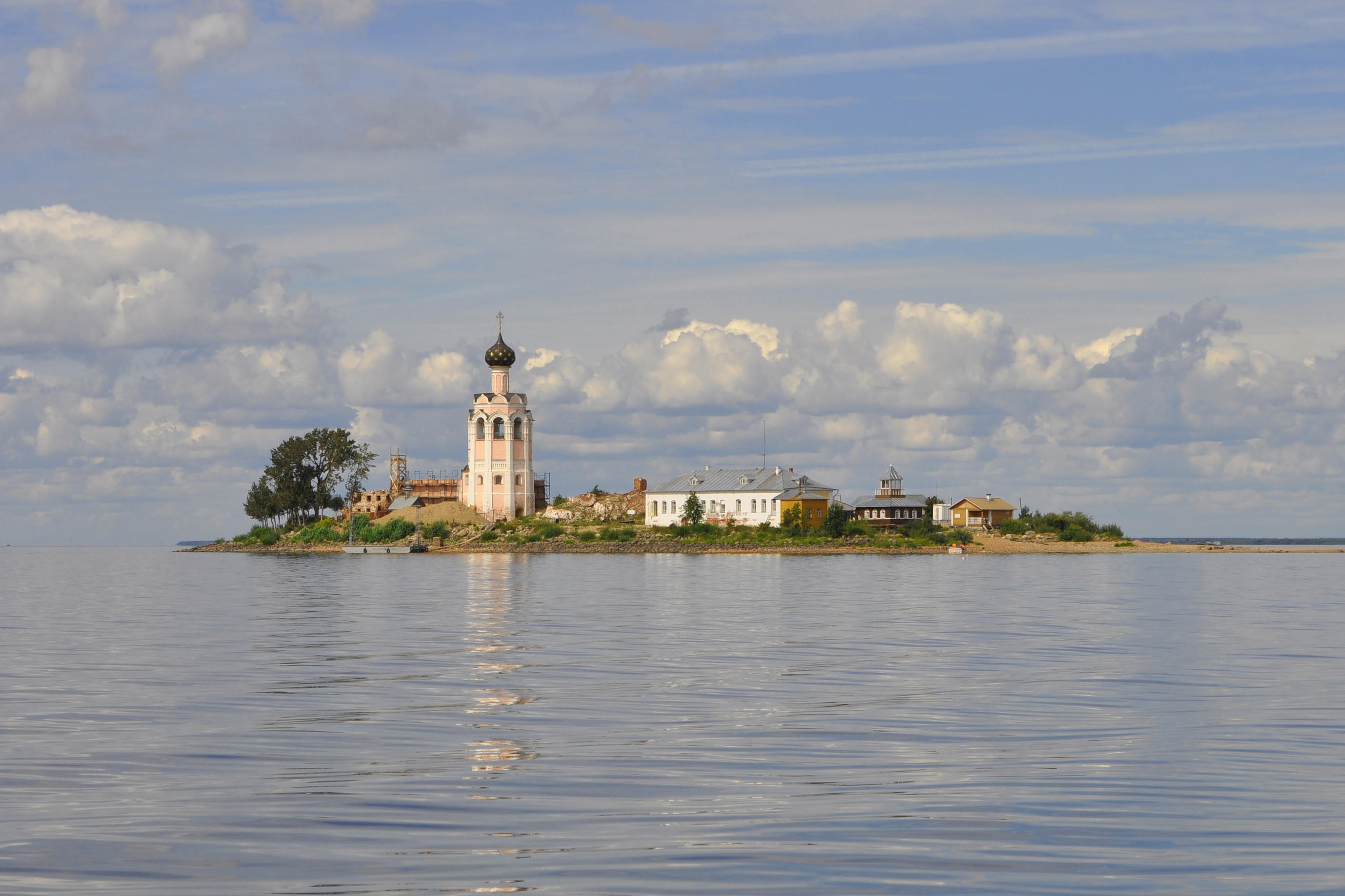
English: Kamenny Monastery in Vologda Oblast.
Русский: Спасо-Каменный монастырь (колокольня и остатки древних зданий), Вологодская область, Усть-Кубинский район, Каменный остров на Кубенском озере.
|
||||
| Date | Taken on 18 August 2013, 12:06:36 | ||||
| Source | Own work | ||||
| Author | Yury Saygon |
| Object location | | View this and other nearby images on: OpenStreetMap |
|---|
|
This image was selected as picture of the day on Wikimedia Commons for 16 June 2014. It was captioned as follows: Other languages:
Čeština: Pravoslavný Spaso-kamenný klášter na Kamenném ostrově v Kubenském jezeře, Usť-Kubinský rajón, Vologdská oblast, Rusko. Nederlands: Klooster Kamenny in het Kubenskoyemeer bij de stad Vologda in Rusland. 中文: 俄罗斯沃洛格达卡门尼修道院。 |
Licensing
I, the copyright holder of this work, hereby publish it under the following license:
This file is licensed under the Creative Commons Attribution-Share Alike 3.0 Unported license.
- You are free:
- to share – to copy, distribute and transmit the work
- to remix – to adapt the work
- Under the following conditions:
- attribution – You must give appropriate credit, provide a link to the license, and indicate if changes were made. You may do so in any reasonable manner, but not in any way that suggests the licensor endorses you or your use.
- share alike – If you remix, transform, or build upon the material, you must distribute your contributions under the same or compatible license as the original.

|
This image was uploaded as part of Wiki Loves Monuments 2013.
|
File history
Click on a date/time to view the file as it appeared at that time.
| Date/Time | Thumbnail | Dimensions | User | Comment | |
|---|---|---|---|---|---|
| current | 23:50, 2 February 2014 | | 2,757 × 1,838 (2.96 MB) | A.Savin | rm watermark, sharpening, cleanup |
| 08:14, 17 September 2013 |  | 2,880 × 1,896 (2.32 MB) | Yury Saygon | User created page with UploadWizard |
File usage
The following page uses this file:
Global file usage
The following other wikis use this file:
- Usage on be-tarask.wikipedia.org
- Usage on bg.wikipedia.org
- Usage on bn.wikipedia.org
- Usage on crh.wikipedia.org
- Usage on cv.wikipedia.org
- Usage on en.wikipedia.org
- Usage on es.wikipedia.org
- Usage on fr.wikipedia.org
- Usage on fr.wikivoyage.org
- Usage on fy.wikipedia.org
- Usage on hu.wikipedia.org
- Usage on ka.wikipedia.org
- Usage on ko.wikipedia.org
- Usage on krc.wikipedia.org
- Usage on lbe.wikipedia.org
- Usage on lt.wikipedia.org
- Usage on os.wikipedia.org
- Usage on pl.wikipedia.org
- Usage on pt.wikipedia.org
- Usage on ru.wikipedia.org
- Usage on ru.wikinews.org
- Usage on ru.wikivoyage.org
- Usage on sah.wikipedia.org
- Usage on tt.wikipedia.org
- Usage on uk.wikipedia.org
- Usage on vi.wikipedia.org
- Usage on www.wikidata.org
- Usage on xal.wikipedia.org
- Usage on zh.wikipedia.org
- Usage on zh.wikivoyage.org