File:Tallinna Raekoda 11-06-2013.jpg
Jump to navigation
Jump to search
Size of this preview: 800 × 553 pixels. Other resolutions: 320 × 221 pixels | 640 × 442 pixels | 1,024 × 708 pixels | 1,280 × 885 pixels | 2,560 × 1,769 pixels | 6,491 × 4,486 pixels.
Original file (6,491 × 4,486 pixels, file size: 8.41 MB, MIME type: image/jpeg)
This is a file from the Wikimedia Commons and may be used by other projects. Information from its description page there is shown below.
Commons is a freely licensed media file repository. |
Summary
| Description |
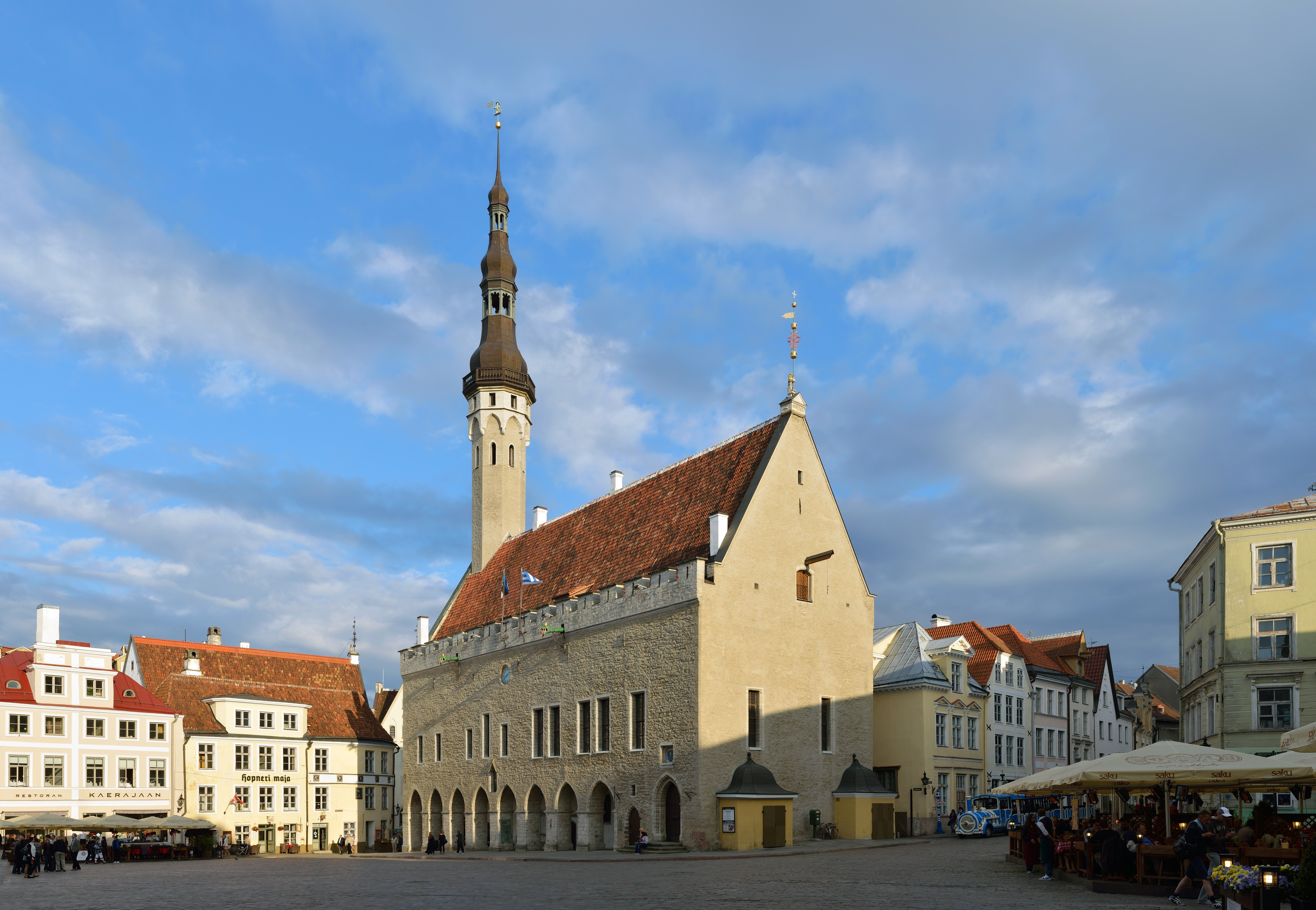
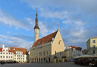
Eesti: Tallinna Raekoda, ehitatud 1402–1404, on vanim raekoda Skandinaavis ja Baltikumis. Gootipärane püramiidjas kiiver asendati 1627. aastal hilisrenessanss-stiilis kiivriga. 1530. aastal asetati torni tippu tuulelipp, millele rahvas pani nimeks Vana Toomas. English: Tallinn Town Hall, built in 1402–1404, is oldest town hall in Scandinavia and Baltic states. Gothic pyramidal spire was replaced by a Late-Renaissance spire in 1627. A weather vane "Old Thomas" was put on top of the spire in 1530.
|
||
| Date | |||
| Source | Own work | ||
| Author | Ivar Leidus |
| Camera location | | View this and other nearby images on: OpenStreetMap |
|---|
| Camera Model | Nikon D5200 |
|---|---|
| Shutter speed | 1/160; |
| Aperture | f/8; |
| Film speed (ISO) | 100; |
This image was created with Hugin.
|
This image was selected as picture of the day on Wikimedia Commons for 20 January 2014. It was captioned as follows: English: Tallinn Town Hall, built in 1402–1404, is the oldest town hall in Scandinavia and the Baltic states. Other languages:
Bosanski: Vijećnica u Tallinnu, sagrađena između 1402. i 1404., je najstarija gradska vijećnica u Skandinaviji i baltičkim državama. Čeština: Radnice v Tallinnu, postavena v letech 1402–1404, nejstarší radnice ve Skandinávii a pobaltských státech. Eesti: Tallinna raekoda, ehitatud 1402–1404, on vanim raekoda Skandinaavis ja Baltikumis. English: Tallinn Town Hall, built in 1402–1404, is the oldest town hall in Scandinavia and the Baltic states. Français : L'hôtel de ville de Tallinn, construit en 1402-1404 est le plus ancien hôtel de ville de la Scandinavie et des pays baltes. Italiano: Il Municipio di Tallinn, costruito nel 1402–1404, è il più antico municipio della Scandinavia e degli Stati baltici. Nederlands: Het stadhuis van Tallinn in Estland werd gebouwd in 1402–1404 en is het oudste stadhuis in Scandinavië en de Baltische staten. Polski: Ratusz w Tallinnie, zbudowany w latach 1402-1404 - jedyny zachowany ratusz gotycki w północnej Europie. Македонски: Талинската градска куќа (изградена во 1402-4 г.) е најстарата градска куќа во Скандинавија и прибалтичите земји. Русский: Таллинская ратуша — старейшая в странах Прибалтики и Скандинавии. . বাংলা : টালিন টাউন হল, তাল্লিন, ইস্তোনিয়া; ১৪০২ থেকে ১৪০৪ সালের মধ্যে নির্মিত। স্ক্যান্ডিনেভিয়া ও বাল্টিক রাজ্য সমূহের মধ্যে সবচেয়ে পুরনো টাউন হল। 中文: 爱沙尼亚塔林市政厅,是整个波罗的海国家和斯堪的纳维亚最古老的市政厅。 |
Licensing
I, the copyright holder of this work, hereby publish it under the following license:
This file is licensed under the Creative Commons Attribution-ShareAlike 3.0 Estonia license.
- You are free:
- to share – to copy, distribute and transmit the work
- to remix – to adapt the work
- Under the following conditions:
- attribution – You must give appropriate credit, provide a link to the license, and indicate if changes were made. You may do so in any reasonable manner, but not in any way that suggests the licensor endorses you or your use.
- share alike – If you remix, transform, or build upon the material, you must distribute your contributions under the same or compatible license as the original.


|
This image was uploaded as part of Wiki Loves Monuments 2013.
|

File history
Click on a date/time to view the file as it appeared at that time.
| Date/Time | Thumbnail | Dimensions | User | Comment | |
|---|---|---|---|---|---|
| current | 14:22, 5 June 2016 | | 6,491 × 4,486 (8.41 MB) | DavidArthur | Levels |
| 06:50, 1 September 2013 |  | 6,491 × 4,486 (16.16 MB) | Iifar | User created page with UploadWizard |
File usage
The following 3 pages use this file:
Global file usage
The following other wikis use this file:
- Usage on ba.wikipedia.org
- Usage on be-tarask.wikipedia.org
- Usage on be.wikipedia.org
- Usage on bg.wikipedia.org
- Usage on bn.wikipedia.org
- Usage on crh.wikipedia.org
- Usage on cv.wikipedia.org
- Usage on da.wikipedia.org
- Usage on de.wikipedia.org
- Usage on en.wikipedia.org
- Usage on et.wikipedia.org
- Usage on fa.wikipedia.org
- Usage on fi.wikipedia.org
- Usage on fr.wikipedia.org
- Usage on hu.wikipedia.org
- Usage on hy.wikipedia.org
- Usage on it.wikipedia.org
- Usage on it.wikivoyage.org
- Usage on ja.wikipedia.org
- Usage on ja.wikivoyage.org
- Usage on ka.wikipedia.org
- Usage on ko.wikipedia.org
- Usage on krc.wikipedia.org
- Usage on lbe.wikipedia.org
- Usage on lt.wikipedia.org
- Usage on lv.wikipedia.org
- Usage on mg.wikipedia.org
- Usage on nl.wikipedia.org
- Usage on no.wikipedia.org
- Usage on os.wikipedia.org
- Usage on pl.wikipedia.org
- Usage on pl.wikivoyage.org
- Usage on pt.wikipedia.org
View more global usage of this file.