File:Torino - mappa metropolitana.svg
Jump to navigation
Jump to search

Size of this PNG preview of this SVG file: 729 × 600 pixels. Other resolutions: 292 × 240 pixels | 584 × 480 pixels | 934 × 768 pixels | 1,245 × 1,024 pixels | 2,490 × 2,048 pixels | 1,599 × 1,315 pixels.
Original file (SVG file, nominally 1,599 × 1,315 pixels, file size: 6.63 MB)
This is a file from the Wikimedia Commons and may be used by other projects. Information from its description page there is shown below.
Commons is a freely licensed media file repository. |
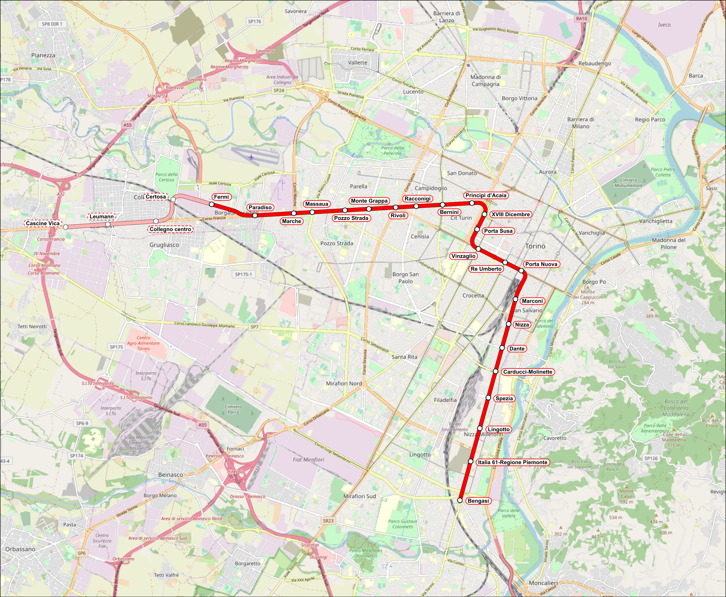
Summary
| Description |
Italiano: Mappa della metropolitana di Torino. |
|||
| Date | (see file history) | |||
| Source | openstreetmap.org | |||
| Creator |
OpenStreetMap contributors |
|||
| Permission (Reusing this file) |
OpenStreetMap data is available under the Open Database License (details). Map tiles are licensed under the Creative Commons Attribution-ShareAlike 2.0 license (CC-BY-SA 2.0).
This file is licensed under the Creative Commons Attribution-Share Alike 2.0 Generic license.
|
|||
| Georeferencing | If inappropriate please set warp_status = skip to hide. | |||
| Other versions |
|

File history
Click on a date/time to view the file as it appeared at that time.
| Date/Time | Thumbnail | Dimensions | User | Comment | |
|---|---|---|---|---|---|
| current | 13:50, 29 April 2021 | | 1,599 × 1,315 (6.63 MB) | Arbalete | Update |
| 18:50, 31 July 2020 |  | 1,599 × 1,315 (6.42 MB) | Arbalete | Aggiungo tratte in costruzione | |
| 10:26, 6 February 2014 |  | 863 × 768 (4.5 MB) | Arbalete | Nuova grafica, più chiara. | |
| 13:23, 8 December 2013 |  | 863 × 768 (4.5 MB) | Arbalete | {{Information |Description ={{it|1=Mappa della metropolitana di Torino.}} |Source ={{own}} |Author =Friedrichstrasse |Date = |Permission = |other_versions = }} |
File usage
There are no pages that use this file.
Global file usage
The following other wikis use this file:
- Usage on de.wikipedia.org
- Usage on eo.wikipedia.org
- Usage on es.wikipedia.org
- Usage on fa.wikipedia.org
- Usage on fr.wikipedia.org
- Usage on hu.wikipedia.org
- Usage on ka.wikipedia.org
- Usage on lt.wikipedia.org
- Usage on nl.wikivoyage.org
- Usage on pl.wikipedia.org
- Usage on pt.wikivoyage.org
- Usage on ru.wikipedia.org
- Usage on th.wikipedia.org
- Usage on uk.wikipedia.org
- Usage on uz.wikipedia.org
- Usage on www.wikidata.org
- Usage on zh.wikipedia.org