File:Vulcan Rock and Di's Cracks map.png
Jump to navigation
Jump to search

Size of this preview: 743 × 599 pixels. Other resolutions: 298 × 240 pixels | 595 × 480 pixels | 952 × 768 pixels | 1,270 × 1,024 pixels | 2,539 × 2,048 pixels | 9,231 × 7,445 pixels.
Original file (9,231 × 7,445 pixels, file size: 3.55 MB, MIME type: image/png)
This is a file from the Wikimedia Commons and may be used by other projects. Information from its description page there is shown below.
Commons is a freely licensed media file repository. |
Summary
| Description |
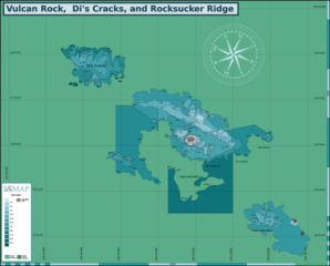
English: Map of the dive site at Vulcan Rock, Hout Bay, Cape Peninsula. |
| Date | |
| Source | Peter Southwood |
| Author | Peter Southwood |
Licensing
Peter Southwood, the copyright holder of this work, hereby publishes it under the following license:
This file is licensed under the Creative Commons Attribution-Share Alike 3.0 Unported license.
Attribution: Peter Southwood
- You are free:
- to share – to copy, distribute and transmit the work
- to remix – to adapt the work
- Under the following conditions:
- attribution – You must give appropriate credit, provide a link to the license, and indicate if changes were made. You may do so in any reasonable manner, but not in any way that suggests the licensor endorses you or your use.
- share alike – If you remix, transform, or build upon the material, you must distribute your contributions under the same or compatible license as the original.
Original upload log
| This file was imported from Wikivoyage WTS. |
The original description page was here. All following user names refer to wts.wikivoyage-old.
org:
- 2010-12-25 07:19 (WT-shared) Pbsouthwood[dead link] 2357×1673 (320622 bytes) {{Imagecredit|credit=Peter Southwood|captureDate=December 2010|location=Hout Bay|source=Peter Southwood|caption=Map of the dive site at Vulc (Import from wikitravel.org/shared)
- 2010-12-25 07:24 (WT-shared) Pbsouthwood[dead link] 2000×1437 (272536 bytes) Correction of image border (Import from wikitravel.org/shared)
- 2011-12-27 11:34 (WT-shared) Pbsouthwood[dead link] 3000×2296 (392002 bytes) 21m contour at Di's Cracks added (Import from wikitravel.org/shared)
- 2012-09-07 19:34 Pbsouthwood[dead link] 3000×2296 (391327 bytes) rm logo
File history
Click on a date/time to view the file as it appeared at that time.
| Date/Time | Thumbnail | Dimensions | User | Comment | |
|---|---|---|---|---|---|
| current | 09:41, 25 October 2023 | | 9,231 × 7,445 (3.55 MB) | Pbsouthwood | Correct position of rocksucker ridge and add contours |
| 10:24, 4 April 2023 |  | 8,678 × 5,969 (3.24 MB) | Pbsouthwood | added 21m ontour south sde of rocksucker ridge | |
| 10:56, 9 January 2023 |  | 8,678 × 5,969 (3.19 MB) | Pbsouthwood | Rocksucker ridge and 24m contour at souh of Vulcan | |
| 16:16, 11 April 2022 |  | 7,800 × 5,969 (2.78 MB) | Pbsouthwood | Added Vulcan west ridge contours | |
| 10:07, 28 February 2022 |  | 7,800 × 5,969 (2.69 MB) | Pbsouthwood | complete 18m contour at Di's Cracks | |
| 17:49, 3 October 2021 |  | 7,800 × 5,969 (2.67 MB) | Pbsouthwood | added some 24m contour and a 14m pinnacle position | |
| 18:05, 23 January 2021 |  | 7,800 × 5,969 (2.58 MB) | Pbsouthwood | add sand patch perimeter to south | |
| 12:18, 12 January 2021 |  | 7,800 × 5,969 (2.51 MB) | Pbsouthwood | various small contours from 18 to 12m at Di's Cracks | |
| 18:13, 4 January 2021 |  | 7,800 × 5,969 (2.41 MB) | Pbsouthwood | added 15m contour round north ridge | |
| 10:47, 30 November 2020 |  | 7,800 × 5,969 (2.28 MB) | Pbsouthwood | North ridge 9 and 12m contours |
File usage
The following 4 pages use this file: