
The dive site Josh's Reef or South West Spot is an offshore rocky reef, in the Off-Whittle southern reefs area of the central west side of False Bay, near Cape Town in the Western Cape province of South Africa.
Understand[edit]


First dived in 2021 by Wreckless Divers.
Position[edit]
1 Josh's Reef pinnacle: S34°15.307' E18°33.113'. The shallowest point known on the reef, and nominal position.
Josh's Reef is a fairly large patch of reef south of Whittle Rock reef surrounded by sand at about 48 m, rising to 32 m on top, with nice ledges to the southwest with a fine display of noble corals. Much of the reef is fairly flat and covered with moderate sized boulders. The reef was surveyed by multibeam sonar in 2022. This site is in the controlled zone of the Table Mountain National Park Marine Protected Area, proclaimed in 2004. A permit is required.
Name[edit]
The name "Josh's Reef" was given by the group from Wreckless Divers who reported the site, and were probably the first to dive it.
Depth[edit]
Maximum depth is about 48 m on the surrounding sand, and the shallowest known point is about 32 m. Average depth of a dive is likely to be about 36 m.
Visibility[edit]
Visibility is likely to be similar to the deeper parts of Whittle Rock reef, and may be better than on the inshore reefs on any given day, but as with any False Bay reef, it is not very predictable, and there may be better visibility at the bottom below a dirty surface layer of plankton, which can follow a period of strong sunshine. The colour of the surface water is not a reliable indicator of the visibility at depth.
Topography[edit]
The reef lies a few hundred metres south of Whittle Rock reef. It is relatively deep, and the profile is flatter than Whittle Rock, with a fairly large area between 33 and 36 metres, covered by moderate to fairly large boulders and some small sand patches. To the southwest of the shallower area there is a relatively high profile area known as Noble Point, for the fine display of noble corals seen there. This area has some fairly vertical rock faces a few metres high, with the local shallow point at about 34 m depth.
Geology: Pre-Cambrian granite batholith of the Peninsula formation.
Conditions[edit]
The site is exposed to wind and waves from all directions, however it is quite deep, so short period waves will not affect conditions on the bottom greatly. Low short swell and light wind is best. The prevailing long period swell is from the southwest, and if long enough can cause surge even on the deep reef. Other waves are generally short period wind waves and chop, but the reef is far enough offshore for a vicious chop to develop in a strong wind, which can be very uncomfortable on the ride back to Simon's Town. The area is protected from north-westerly swell, and to a lesser extent south-westerly swell by the Cape Peninsula, but longer period south-westerly swell will refract round Cape Point, and though attenuated, will reach this site.
Surface currents have been measured at up to about 2 kilometers per hour, caused by recent wind, and in a similar direction, offset in an anticlockwise Ekman spiral by the Coriolis effect (the current is offset more at greater depth, but proportionately weaker). The skipper should drop divers off a bit up-current of the shotline, which may not be quite the same as upwind of it, and the drift direction of a boat with significant windage is not quite the same as the drift direction of an almost completely immersed diver.
Water temperature may vary with depth. A thermocline develops in midsummer, gets deeper in autumn, and dissipates in winter. The visibility may also change significantly below the thermocline. In winter the water may be the same temperature from top to bottom, and as there is less sunlight to power the phytoplankton blooms, the visibility and natural illumination can be better even though there is less light. There is no specific time of year for diving this site, you just have to wait for low swell and light winds, and take your chances with visibility.
Get in[edit]
The site is only accessible by boat. It is about 8.5 km from the slipway at Miller's Point, but boats may also leave from Simon's Town jetty. On a good day in a fast boat it is a bit less than a half hour run from Simon's Town Jetty, a distance of about 14.5 km. Occasionally boats may leave from Gordon's Bay Old Harbour or Harbour Island marina, which are both about 29.5 km away.
Do[edit]
Dive at one of the listed drop points and explore the reef. Let us know what you find.
1 Josh's Reef pinnacle: S34°15.307' E18°33.113'. The shallowest point known on the reef.
2 Noble Coral Point pinnacle: S34°15.334' E18°33.075'. To the southwest of the shallowest area there is a relatively high profile area known as Noble Point, for the fine display of noble corals seen there. This area has some fairly vertical rock faces a few metres high, with the local shallow point at about 34 m depth.
See[edit]
Marine life[edit]
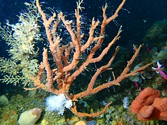
A fine display of noble corals has been reported from the mark known as Noble Coral Point.
-
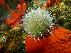 Deepwater urchin
 -
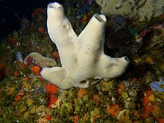 Sponge
 -
 Sponge
 -
 Sponge
 -
 Noble coral
 -
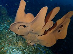
 White cauliflower soft coral


Photography[edit]
Not much is known about the site yet, so macro with a modelling light and flash is a fairly safe choice, as it may be quite dark.
Suggested routes[edit]
No routes known. You could start at Noble Coral Point, but where you go from there is up to you.
Stay safe[edit]
Hazards[edit]
The site is relatively deep, and extends below the range normally considered appropriate for recreational diving. Even the shallowest point is below 30 m. This is a depth range where most divers would not consider an emergency swimming ascent an acceptable response to an out of air emergency, as the risk of decompression sickness would be relatively high.
Skills[edit]
Suitable skills for decompression diving are recommended, even if the dive plan does not include obligatory decompression. These include the ability to deploy a decompression buoy, and the ability to accurately follow a decompression schedule. Good buddy diving skills or solo diving skills are also strongly recommended.
Equipment[edit]
Adequate and reliable alternative breathing gas supply, as the depth is beyond the range for which emergency swimming ascent is a reasonable response. A decompression buoy is strongly recommended, and may be required by the service provider.
Nearby[edit]

Other nearby offshore dive sites of False Bay:
- 1 SATS General Botha
- 2 Off-Whittle Ridge
- 3 Whittle Rock
- 4 Bruce's Mark
- 5 Midway Ridge
- 6 Sandy-top Ridge
- 7 Southwood's Corner
- 8 Wreckless Ridge
- 9 Lonehill Reef
- 10 Deep South Whittle Reef
Back to the Alphabetical list of sites, or list of reef dive sites in the Whittle Rock and surrounds offshore area
Other regional dive sites: