
The dive site Wreckless Ridge is an offshore rocky reef in the central west side of False Bay, near Cape Town in the Western Cape province of South Africa.
Understand[edit]
First dived in 2021 by Wreckless Divers.

A pretty reef, fairly deep on the sand, but with a fair amount of area above 40 m. Compact, and quite steep sided.
Position[edit]
1 Wreckless Ridge: S34°15.541' E18°33.970'
A fairly small separate granite ridge reef to the southeast of Whittle Rock. This site is not in a Marine Protected Area. A permit is not required.
Name[edit]
The site is named after the RIB dive boat Wreckless, which found the reef and was the first to report diving the site.
Depth[edit]
Maximum depth is about 48 m on the sand, and the top of the ridge is about 30 m. (Average depth of a dive is likely to be about 36 m.
Visibility[edit]
The shallower parts of the reef may have good visibility even when the deeper areas are silty.
Topography[edit]
The reef lies with its long axis roughly northwest-southeast. It is about 350 m long and somewhere around 50 to 80 m wide. The northeast face is steep, with occasional indentations and cracks, and rises to a long ridge on the long axis at about 33 m. The top of the reef slopes down to the southwest at a fairly flat angle at the top, but is reported to be steep at the southwest edge. There is a shallow gully with a sandy bottom running along part of the length, approximately parallel to the long axis, and somewhat closer to the southwest side. The site is mostly unexplored, but has been surveyed by multibeam sonar in 2023.
Geology: Pre-Cambrian granite of the Peninsula pluton.
Conditions[edit]
The site is exposed to wind from all directions, so should be dived in light winds and low swell.
The site will probably usually be at it's best in winter but there will also be occasional opportunities at other times when the swell is low.
This is an area which usually has a thermocline in late summer, and may have poor visibility near the surface caused by plankton blooms in sunny weather. If the visibility opens up below the plankton layer, it will probably be quite dark on the reef.
Get in[edit]
The site is only accessible by boat. It is about 8.5? km from the slipway at Miller's Point, but boats may also leave from Simon's Town jetty. On a good day in a fast boat it is a bit less than a half hour run from Simon's Town Jetty, a distance of about 14.5? km. Occasionally boats may leave from Gordon's Bay Old Harbour or Harbour Island marina, which are both about 29.5? km away.
Do[edit]
Routes[edit]
There are no recommended routes yet, as the site has not been dived very often and is largely unexplored.
See[edit]
Marine life[edit]
The ecology is much like that of the other deeper reefs of the region. As usual, there is more diversity where there is more topographic variation, particularly on steeper areas, under overhangs, and along edges where there is more water movement, which is good for filter feeders. There may be shoals of small fish near the reef, and cryptic species close to the reef surface and in areas of high decimetre scale rugosity.
-
 Divers at Wreckless Ridge
 -
 Sea fans
 -
 Fan hydroid
 -
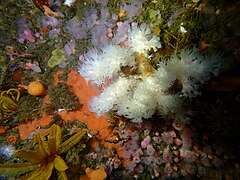 Soft corals
 -
 Fan hydroids
 -
 Tubeworms
 -
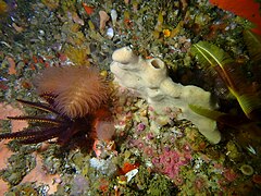
 Sea squirt
 -
 Sponges
 -
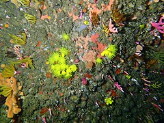 Zoanthids
 -
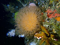 Sunburst soft coral
 -
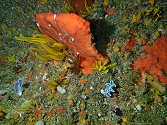
 Sponge
 -
 Sponge
 -
 Deepwater sea urchin
 -
 Strawberry anemones
 -
 Sponge
 -
 Noble corals


Features[edit]
The northeast face is long, steep, and high, from sand bottom to a hogsback ridge on top. There is a long gully parallel to the long axis near the southwest edge.
Photography[edit]
It will usually be fairly dark, and backscatter will limit the use of artificial lighting to relatively short distances, so macro and wide angle close-up will be most likely to be useful.
Stay safe[edit]
Hazards[edit]
There are no known site-specific hazards other than the depth. Most of the site is below the depth range usually accepted as suitable for recreational diving, or for emergency swimming ascent. Surface currents due to wind are likely and may take the divers away from the descent area during an ascent with decompression stops.
Skills[edit]
The competence to follow suitable decompression procedures is recommended. This includes carrying and using appropriate gases and deploying a decompression buoy to mark the position of the divers during ascent.
Equipment[edit]
Adequate and reliable alternative breathing gas supply, as the depth is beyond the range for which emergency swimming ascent is a reasonable response. A decompression buoy for each diver is strongly recommended, and may be required by the service provider. A fully redundant emergency gas supply is recommended. Use of breathing gas mixtures appropriate to the depth is recommended, and decompression stops are likely to be needed.
Nearby[edit]

Other offshore dive sites of False Bay:
- 1 SATS General Botha
- 2 Off-Whittle Ridge
- 3 Whittle Rock
- 4 Bruce's Mark
- 5 Midway Ridge
- 6 Sandy-top Ridge
- 7 Southwood's Corner
- 8 Josh's Reef
- 9 Lonehill Reef
- 10 Deep South Whittle Reef
Back to the Alphabetical list of sites, or list of reef dive sites in the Whittle Rock and surrounds offshore area
Other regional dive sites:
- Dive sites of Table Bay and approaches,
- Dive sites of the Cape Peninsula west coast
- Dive sites of the Cape Peninsula east coast
- Dive sites of False Bay east coast
- Fresh water dive sites of the Cape Town Metropolitan Area