
Faneromeni Square
This article needs additional citations for verification. (March 2024) |
| Faneromeni Square | |
|---|---|
 | |
| Location | |
 | |
| Information | |
| Type | Public, historical |
Faneromeni Square (Greek: Πλατεία Φανερωμένης; Turkish: Faneromeni Meydanı) is an important historical square in Nicosia. It is in an ancient part of Nicosia, within city walls built when it was under Venetian rule.
It hosts a number of historical buildings and monuments including Faneromeni Church, Faneromeni School, Faneromeni Library, and the Marble Mausoleum.
Overview and historical background[edit]

Faneromeni Square was the centre of Nicosia before Eleftheria Square superseded it in 1974.
Faneromeni Church dominates the centre of the square; it was built in 1872 on the site of an ancient Orthodox nunnery. The church is dedicated to Holy Mary and it is the largest church within the city walls of Nicosia. Architecturally the Church edifice features a mixture of Neoclassical, Byzantine and Medieval Latin styles.[1]
Faneromeni School, founded by Archbishop Makarios I in 1857, was the first all-girls school in Cyprus. It was founded to improve rates of literacy among girls and women on the island.
The Marble Mausoleum on the eastern side of Faneromeni Church is situated at the front of the building. It was built in memory of four clerics executed by the Ottoman governor in 1821, following the Cypriot revolt after the Greek War of Independence was declared.
The square is surrounded by several neoclassical buildings featuring predominantly Greek, as well as, local Cypriot architectural influences. These include the Faneromeni Library.
Today the square is a meeting point for the anarchist movement of Cyprus, anti-authoritarians, libertarians, many artists and musicians. It is also a stronghold of the antifascist movement on the island.[2][3] The square is considered a central point for counterculture on the island.[4]
Gallery[edit]
Historical buildings and monuments[edit]
-
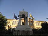 Marble Mausoleum & Faneromeni School
 -
 Marble Mausoleum in Faneromeni Square
 -
 Faneromeni School façade
 -
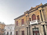
 Faneromeni Library
 -
 Faneromeni Library


Faneromeni Church[edit]
-
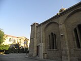
 Faneromeni Church: entrance to the square
 -
 Faneromeni Church & School
 -
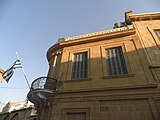
 Faneromeni Church façade
 -
 Faneromeni Church façade (detail)


Typical architecture[edit]
-
 Typical architecture with Faneromeni Church in the background
 -
 Traditional architecture
 -
 Building with traditional Greek and local Cypriot Neoclassical features
 -
 Detail of building adjacent to Faneromeni Church
 -
 Cluster of Neoclassical buildings & Faneromeni Library


35°10′25″N 33°21′46″E / 35.1735°N 33.3628°E
References[edit]
- ^ Petrou, Margarita; Charmpis, Dimos (2019), Aguilar, Rafael; Torrealva, Daniel; Moreira, Susana; Pando, Miguel A. (eds.), "Iron Ties Originally Anchored into Masonry as a Historical Construction Technology – Case Study: A Church in Cyprus", Structural Analysis of Historical Constructions, vol. 18, Cham: Springer International Publishing, pp. 153–161, doi:10.1007/978-3-319-99441-3_15, ISBN 978-3-319-99440-6, retrieved 2024-02-29
- ^ Ioannou, Gregoris (2019). "Social Activism and the City: Cultural Sociology and Radical Politics in 21st Century Cyprus". Cyprus Review. 31 (1): 209–238. ISSN 2547-8974.
- ^ Christou, Georgina (2021). "Agitative pauses, intentional moorings: Stasis as resistance". Environment and Planning D: Society and Space. 39 (4): 685–703. doi:10.1177/02637758211027577. ISSN 0263-7758.
- ^ Christou, Georgina (2023-01-26). "Refusing to Grow Old: The Antichronocratic Labour of Cypriot Activist Youth and What It Can Teach Us About Decolonizing Childhood and Related Knowledge Production". Journal of Childhood Studies: 73–84. doi:10.18357/jcs202320467. ISSN 2371-4115.