
Kamikōchi

Kamikōchi (上高地, Upper Highlands) is a remote mountainous highland valley within the Hida Mountains range, in the western region of Nagano Prefecture, Japan.
It has been preserved in its natural state within Chūbu-Sangaku National Park. It is designated as one of Japan's National Cultural Assets, on the list of Special Natural Monuments and Special Places of Scenic Beauty.[1] It is sometimes referred to as the "Japanese Yosemite Valley," although it is considerably smaller than its Californian counterpart.
Geography[edit]
.jpg)
Kamikōchi is a high mountain valley approximately 18 kilometers in length. The average elevation of the valley floor ranges between roughly 1,400 m (4,600 ft) above sea level at the south end and roughly 1,600 m (5,200 ft) at the northern tip.
Kamikōchi is located in the Hida Mountains, the "Northern Alps" of the Japanese Alps. The surrounding mountains reach 3,190 m (10,470 ft). Kamikōchi is bordered on its northern end by Mount Hotaka, and on its southern end by Mount Yake, an active volcano.
The Azusa River, the headwater of Japan's longest river, the Shinano River, flows the length of the valley, filling Lake Taishō at the base of Mt. Yake. Lake Taishō received its name because it was formed by the eruption of Mt. Yake in 1915, which was part of the Taishō period in Japan.
Because of the relatively flat topography of the Kamikochi Valley, marshes and ponds are a common feature, including the Takezawa Marsh, Tashiro Pond, and Myojin Pond. As the waters are mainly from melted snow runoff or underground aquifers, the water temperature is cold, even in the height of summer. The Tokusawa area at the far northern end of the valley served as a grazing area for horses and cattle until 1934, when the area was completely integrated into the park.
Hiking[edit]
Kamikochi is a very popular hiking destination, there are an abundance of mountain huts and camping sites that make overnight hiking easy to manage. The most famous hike in the area is Yarigatake which is easily accessible from Kamikochi and often combined with Oku-Hotaka as a multi-day hike. [2]
History[edit]

Kamikōchi was logged extensively until the mid-19th Century. The Rev. Walter Weston, a British Anglican missionary, is credited through his writing with sparking interest in recreational mountaineering in Japan and also with lobbying to preserve the Kamikōchi area. Each year in June, the Weston Festival is celebrated at Kamikochi in recognition of his contribution to the conservation of the Northern Japan Alps.
Japanese novelist Ryunosuke Akutagawa also contributed to a boom in domestic tourism when he published his book Kappa in 1927. The naming of the Kappa-Bashi, the narrow pedestrian suspension bridge over the Azusa River mentioned in the novel predates the book's publication. The origin of the naming of the bridge is uncertain, but is more commonly thought to refer to Kappa, mythical water deities said to inhabit Japan's mountain streams and rivers.
kanji 神垣内 (Kami-ko-uchi) were also used to write "Kamikōchi," but 上高地 (Kami-kō-chi) has become the common way to write the name.
Park facilities include two camping areas, a number of hotels (western-style and traditional Japanese ryokan), a post office, a tourist information center and some souvenir shops, mainly located between the bus and taxi terminal and Kappa-bashi bridge.
Access and transportation[edit]
As the entire Kamikochi valley is protected as part of the Chūbu-Sangaku National Park, road access is only granted to shuttle buses, taxis, forestry and maintenance workers' vehicles. Private vehicles have been restricted from entering the park beyond the Kama Tunnel for both traffic management and environmental reasons since 1994.[3] Private cars are required to park at either the Hirayu or Sawando parking area from where shuttle buses or taxis transport visitors directly to the centrally located park visitor center.

For rail passengers approaching from Matsumoto an integrated park transportation ticket is available using the Highland Rail service of the Kamikōchi Line to Shin-Shimashima rail terminal and then the Highland Bus service provided by Alpico Kōtsū. The journey to the center of the park from Matsumoto Station by rail and shuttle bus takes approximately 1 hour 50 minutes.[4]
Longer distance and overnight buses directly to the park are available from Tokyo (Shinjuku), Nagoya, Kyoto, and Osaka.
The park is officially open from mid-April to mid-November, with peak crowds during the summer school holidays (end of July through the end of August) and when the autumn leaves are at their peak in October.[5]
Surrounding mountains[edit]


-
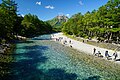 Azusa River flows through Kamikōchi
 -
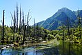 Gakusawa wetlands
 -
 Lake Taisho


See also[edit]
- List of Special Places of Scenic Beauty, Special Historic Sites and Special Natural Monuments
- Tourism in Japan
- Chūbu-Sangaku National Park
References[edit]
- ^ Kamikōchi Archived 2008-07-30 at the Wayback Machine. (in Japanese) The Agency for Cultural Affairs. Accessed June 28, 2008.
- ^ "Hiking in Kamikochi, Nagano | Hike Master Japan". Hikemaster. Retrieved 2022-04-15.
- ^ "Traffic Restrictions in Kamikochi". Alpico. Matsumoto Electric Railway. Archived from the original on 10 January 2015. Retrieved 13 August 2014.
- ^ "Kamikochi Shuttle Bus Timetable". Japan Alps Kamikochi Official Website. Park Website. Retrieved 13 August 2014.
- ^ Hohmann, Skye, "Winter kept us warm in Kamikochi's silence", Japan Times, 4 March 2012, p. 10.
External links[edit]
- (in Japanese)—Official Kamikōchi website
- (in English)—Kamikochi.org: Kamikochi website
- Kamikōchi Visitors Center—(in Japanese)
- Japan Atlas: Kamikōchi
- Japan National Tourism Organization: Kamikōchi
- A guide to hiking in Kamikochi
36°14′49″N 137°38′00″E / 36.246968°N 137.633333°E
| International | |
|---|---|
| National | |