
Moher Tower
| Moher Tower | |
|---|---|
Irish: Túr an Mhothair | |
 Moher Tower | |
 | |
| Former names | Moher Uí Ruis or Moher Uí Ruidhin |
| General information | |
| Status | ruin |
| Type | signaling/watchtower |
| Location | Hag's Head, County Clare |
| Country | Ireland |
| Coordinates | 52°56′54″N 9°28′04″W / 52.948212°N 9.467861°W |
| Estimated completion | c.1808[1] |
Moher Tower (Irish: Túr an Mhothair; historically Moher Uí Ruis or Moher Uí Ruidhin)[2] is the stone ruin of an old Napoleonic-era watchtower which stands on Hag's Head, at the southern end of the Cliffs of Moher, in County Clare, Ireland.
History[edit]
The current tower (which was built c.1808) stands close to the site of a much earlier promontory fort, known as Mothar or Moher.[3] This earlier fortification stood until at least 1780 and is mentioned in an account from John Lloyd's a Short Tour Of Clare (1780).[4] The earlier fortification was demolished in 1808 to provide material for a new lookout/signaling tower.[2] This was built nearby during the Napoleonic Wars (1803–1815), at a time when similar towers were built along Atlantic coasts to counter fears of invasion during Napoleon's reign in Europe.[2][5]
Construction and use[edit]
The building is a single, nearly square, tower with two rectilinear bartizans protruding from the top of its eastern wall, and one from the western wall.[1] Facing the Atlantic Ocean, the structure appears to have incorporated a fireplace on at least 2 floors, and a dry stone roof which has since mostly caved in.[citation needed]
In summer the tower ruin is occupied by the many choughs and similar birds native to the area. The tower is sometimes used as a refuge by visitors to the Cliffs of Moher who become stranded on the southern cliff path during storms that blow in from the Atlantic.[citation needed]
Gallery[edit]
-
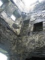 Inside Moher Tower
 -
 Moher Tower on Hag's Head


References[edit]
- ^ a b Mary Tunney (2016). Sites and Monuments Record. National Monuments Service.
CL014-010002- [..] Signal tower [..] Situated close to Hag's Head and within a promontory fort (CL014-010001-). The ruins of a Napoleonic signal tower built in 1808. A two-storey square tower defended by two rectangular bartizans protruding from the top of the E wall and one from the W wall
- ^ a b c Thomas Johnson Westropp (1905). "Archaeology of the Burren: Prehistoric Forts and Dolmens in North Clare (Part IV: Moher Ui Ruis; Lehinch; Dooneeve; Cahers)". Journal of the Royal Society of Antiquaries of Ireland. xxxv.
- ^ Doolin Web Solutions (2010). "About the Cliffs of Moher". cliffs-moher.com. Archived from the original on 2 March 2018.
The Napoleonic signal tower at Hags Head was built [..] close to the site of a long gone 1st century BC ruined fort "Mothar" from which the Cliffs get their name
- ^ John Lloyd (1780). "Burren, Mohar, Liscanor Bay". Lloyd's Tour of Clare. John Busteed & George Trinder – via Clare Library.
- ^ Eamonn Kelly (2009). "How The Cliffs Were Named". The Cliffs of Moher. Matthew Kelly. ISBN 0-9561746-0-4.
The present tower built near the site of the old Moher Ui Ruidhin was built by the British as a lookout tower during the Napoleonic Wars