Diving at Murphy's

The dive site Murphy's or Outer Miller's Point is an offshore, rocky reef, in the Miller's Point area on the Cape Peninsula, near Cape Town in the Western Cape province of South Africa.
Understand[edit]
This is an alternative site in the Millers Point area, just outside the Castle Rocks restricted zone of the Marine Protected Area
Position[edit]
- 1 Murphy's: S34°13.958 E018°28.988
Roughly north of Boat Rock and south-east of the furthest offshore rock of Miller's Point.
This site is in a Marine Protected Area (2004). A permit is required.
Name[edit]
The name "Murphy's" is derived from Murphy's Law, as the first recorded dive at the site was nearly cancelled due to battery problems on the boat, the survey float GPS battery ran down and no map track was recorded, and one of the divers had the wrong settings on his camera. Other than that it was a great dive.
Depth[edit]
Maximum depth is about 21 m. and the top of the pinnacle is about 14.5 m. Average depth is likely to be about 18 to 20 m.
Visibility[edit]
Visibility will be much like elsewhere in the Miller's point area, and is likely to be between 6 and 10 m on a good day.
Topography[edit]
The pinnacle is very small, but there are several large outcrops nearby, rising to above 18m, and a lot of low broken reef around that, with sand patches. The reef is separated from the adjacent reefs at Boat Rock and Miller's Point by sandy gaps.
Geology: Pre-Cambrian granite corestone of the Peninsula pluton.
Conditions[edit]
The site is exposed to south easterly wind and swell, so should be dived when the swell is from the south to north-west. The site is reasonably protected from southerly swells, but if a strong south easterly wind develops then the surface will get unpleasant quite quickly
The site is at it's best in winter but there are also occasional opportunities in other seasons.
Get in[edit]
Usually dived from a boat, though shore dives are possible and have been done. The route to the site from Millers Point crosses a heavily used ski-boat traffic lane, as it is on the shortest path from the public slipway at Miller's Point to the fishing grounds near Cape Point, so it is an area of relatively high risk of being run down by a boat.
The site is about 1km from Miller's Point slipway, or 8.2 km from Simon's Town jetty.
See[edit]
Marine life[edit]
Marine life is typical for the area and depth range. The usual echinoderms, anemones, sponges and bryozoans cover the rocks, and a reasonable variety of local reef fish swim around them. Nudibranchs and crustaceans are fairly common, including the hotlips spider crab.
-
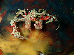 Hotlips spider crab
 -
 Flagellar sea fan
 -
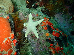 Grey star
 -
 Hairy brittlestars
 -
 Large skate egg-case
 -
 Horse mussel
 -
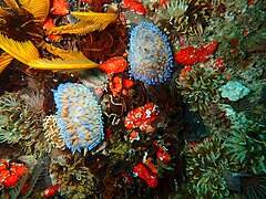 Gasflame nudibranchs


Photography[edit]
Fairly good macro site, not much in the way of spectacular scenery, but lots of small, colourful critters.
Suggested routes[edit]
Start at the pinnacle, and just swim around looking for small, interesting animals. They could be anywhere, but concentrate on crevices, overhangs and near-vertical surfaces.
Stay safe[edit]
Hazards[edit]
Boat traffic can be heavy when the snoek or yellowtail are running. Ascend at the shotline or send up an SMB to make your position visible to your dive boat and all the other boats which may be passing. If doing this as a shore dive, it will be safer to spend as little time at the surface as possible, and if or when you are at the surface, make yourself as visible as possible, and get out of the high traffic zone as soon as possible.
Skills[edit]
No special skills required. Entry-level divers can dive the site if reasonably competent and able to use a DSMB.
Equipment[edit]
DSMB highly recommended, so you can alert passing boats of your position when surfacing and while on the surface waiting to be picked up by the boat.
Nearby[edit]

- 1 Miller's Point tidal pool
- 2 Boat Rock
- 3 Festival Pinnacle
- 4 Fan Reef
- 5 Shark Alley
- 6 Pyramid Rock
- 7 Phone reef
- 8 Outer Castle
- 9 Castle Pinnacles
- 10 Giant's Castle
- 11 North Pie Rock Reef
- 12 Castle Rocks Point Reefs
- 13 South Pie Rock Pinnacles
- West Pie Rock Reef
Back to the Alphabetical list of sites, or list of dive sites in the Miller's Point area
Other regional dive sites:
- Dive sites of Table Bay and approaches,
- Dive sites of the Cape Peninsula west coast
- Dive sites of False Bay offshore and approaches
- Dive sites of False Bay east coast
- Fresh water dive sites of the Cape Town Metropolitan Area