Diving at Steenbras Deep

The dive site Steenbras Deep is an offshore rocky reef in the eastern central area of False Bay, near Cape Town in the Western Cape province of South Africa.
Understand[edit]


This site is at the southern end of a long ridge. It is not dived very frequently as it is a long boat trip and visibility is not very predictable, though it can be better than other sites on the east side of the bay.
Position[edit]
About 6 km west of Boskloof Point and Steenbras River mouth, and shown on the SA Navy charts but not named.
This site is not in a Marine Protected Area (2004). A permit is not required.
Name[edit]
The name "Steenbras Deep" is a contraction of Steenbras Deep Reef. This has been the name used by divers and fishermen for this reef for decades at least, and is more likely to refer to the nearby Steenbras River than to any of the fish species known as Steenbras, though this is also a possible derivation.
Depth[edit]
South Pinnacle (1st Pinnacle) is about 17 m at the highest point, and 30 m maximum depth. North Pinnacle (2nd Pinnacle) is about 18 m at top and about 27 m at the sand
Visibility[edit]
Visibility is not easy to predict, but can be better than other east False Bay sites if there is a red tide, as it is deep enough that the bottom water may be clear, though the light level may be low. It can be better than 10 m on the reef while the surface and top several metres has less than 3 m viz. Good visibility at the surface may not predict good visibility near the bottom. There have been occasions where a band of poor visibility occurs in mid-water with better visibility both above and below. This does not appear to be explained in the scientific literature, but may be associated with a thermocline.
Topography[edit]
South Pinnacle or 1st Pinnacle: Large area of irregular shape, about 130 m east to west amd 200 m north to south at 27 m, with the top at about 18 m. Perimeter drops off fairly steeply, with several large and fairly deep gullies cutting into the outcrop from several directions. There are sand patches at about 30 m depth scattered around the outcrop, and more reef in other places. There are also a few 18 m pinnacles near to the plateau area. There are places with a fairly flat shingle bottom adjacent to the reef.
North Pinnacle or 2nd Pinnacle: Irregular shaped reef about 40 m diameter at 21 m, of hard, fine-grained sedimentary rock. Some jointing or bedding planes about N-S magnetic. If this is the strike then dip is very steep, nearly vertical. A sample of rock has been collected and awaits analysis. The pinnacle is irregular in shape, with a large number of cracks, grooves and indentations, mostly not very deep. Sand is coarse and shelly with lots of bryozoan detritus at the edge of the reef at about 29 m. The top of the pinnacle is at about 18 m. There is a small section of lower reef to the south-west, mostly deeper than 21 m
Geology: The geology of the area is not known, but the rock is sedimentary, and the shape of the reef is more consistent with sandstone than shale, as it has a chunky, squared off looking structure, much like the Rooi-Els reefs. Strike is not recorded, but dip may be steep, based on the shape of the ridges and gullies. The rock is very similar to that of Drop Zone and Sterretjies. The north-westerm section of the South Pinnacle area appears to have near vertical dip, and the top surface of the outcrop is quite jagged, similar to outcrops of dark rock at Blousteen and Gordon's Bay, which are known to be Tygerberg formation. The surrounding bottom in this area includes large areas of water-smoothed shingle.
Conditions[edit]
The site is exposed to wind and waves from all directions, however it is quite deep, so short period waves will not affect conditions on the bottom greatly. Low short swell, light wind is best. There may be a thermocline, and the visibility may change significantly below the thermocline. 17°C at the surface with 2 to 5 m visibility above the thermocline and 11°C with 8 to 10 m visibility below the thermocline is possible and conditions at depth are not easily predictable. There is no specific time of year for diving this site, you just have to wait for low swell and light winds.
A light current has been reported occasionally, particularly at the surface, which can make it tricky to find the right part of the reef without a heavy shotline. This current has been measured at 0.9 km/hr setting SSE, but other directions and strengths are possible. The surface current is usually wind driven, and will therefore flow left of the wind direction due to Coriolis effects, but will lag a bit when the wind changes.
Get in[edit]
The site is only accessible by boat. It is approximately 10.5 km from Harbour Island, or 10.1 km from Gordon’s Bay harbour.
See[edit]
Marine life[edit]
There is quite a good variety of invertebrate life on the reef. It is similar to, but has a slightly different ambience compared with the reefs on the east shoreline, and is very different to the granite reefs on the west side of the bay. Much of the reef has high profile, and the surface is generally rugose, with a lot of decimetre scale complexity, including quite a number of narrow crevices which can trap a shot-weight. There is a high density of soft coral and sponge cover which is spectacularly colourful when the coral polyps are open.
-
 The Frilled nudibranch, Leminda millecra is fairly common at this site
 -
 The reef at Steenbras Deep
 -
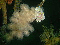 Violet spotted anemone and soft corals
 -
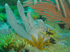 Sponge
 -
 Sponge


Photography[edit]
The site is good for photography. The visibility is unpredictable, and often not very good, so lenses suitable for close-up work are most likely to produce good results, and artificial lighting will be necessary in almost all circumstances. External flash is recommended to minimize backscatter.
Routes[edit]
No particular route recommended. Put down a shotline on top of the reef, descend on this and go down the side of the reef to the sand, then work your way up the pinnacle. There is often a slight current, so do not leave the boat unattended. For preference ascend on the anchor line or a shotline, otherwise a SMB should be used. This is not a good place to be lost.
Stay safe[edit]
Hazards[edit]
Strong winds may develop over a short time, however these are usually predictable, so check the weather forecast.
Skills[edit]
Tha ability to deploy a DSBM is recommended. The site is not suitable for novices as the depth is on their extreme limit and the site is far offshore.
Equipment[edit]
A light can be useful if the visibility at the surface is bad. A reel and DSMB are highly recommended, so the boat can find you if you drift away, Nitrox can greatly extend no-decompression time. A dry suit would be good if diving on Nitrox, as it may be quite cold at the bottom.
Nearby[edit]

Other offshore dive sites of False Bay:
- 1 Choirboys Reef
- 2 Seal Island
- 3 Drop Zone
- 4 East Shoal
- 5 Moddergat
- 6 Sterretjies Reef
- 7 York Shoal
- 8 SAS Fleur
- 9 Offshore Barges – North Barge
- 10 Blue Flame Pinnacles
- 11 SATS General Botha
- 12 Off-Whittle Ridge
- 13 SAS Bloemfontein
- 14 Whittle Rock
- 15 Bruce's Mark
- 16 Deep South Whittle Reef
- 17 Anvil Rock
- 18 SS Lusitania
- 19 Rocky Bank
Back to the Alphabetical list of sites, or list of reef dive sites in the northern False Bay offshore area
Other regional dive sites: