East Coulee is a small community in the Southern Alberta region of Alberta, Canada, near the community of Cambria. It is part of the Town of Drumheller, which is a hub for dinosaur tourism.
Understand[edit]
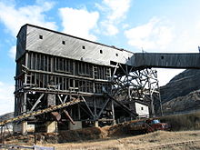
East Coulee is known for its Atlas Coal Mine. East Coulee lies in the Red Deer River valley at an elevation of 675 m (2,215 ft). It was one of the filming locations of the television series MythQuest.
Get in[edit]
By car[edit]
East Coulee is on Highway 10, approximately 20 km (12 mi) southeast of Drumheller's main townsite and 112 km (70 mi) northeast of Calgary.
Get around[edit]
See[edit]

- 1 Atlas Coal Mine National Historic Site, 110 Century Drive (20 minutes SE of Drumheller along Highway 10), ☏ +1 403-822-2220. May 1–Jun 22: 9:30AM-5PM; Jun 23–Aug 26: 9:45AM-7:30PM; Aug 27–Oct 8: 9:30AM-5PM. Climb the last wooden tipple in Canada. Learn how coal was sorted, stored, and shipped in this unique processing plant. Walk the gantry – a gradual ascent - 125 feet up to the top of the Tipple to learn about the reality young boys faced: that the dangers of the surface were a training ground for the formidable "belly of the beast. Follow in the historic footsteps of the miners. Put on a cap lamp and hike up the inclined conveyer tunnel to the mine entry, set high in the Badlands. Explore the dark side of coal mining – learn about accidents, brawls, the women, and the unmentionable side of Drumheller Valley history. $10 per person, $30 family.
- 2 East Coulee School Museum, 359 2nd Ave (from Hwy 10, go past the old garage and the East Coulee Motor Inn; turn right at the second intersection, at the Community Hall; museum is dead ahead), ☏ +1 403-822-3970, fax: +1 403 822-2111, info@ecsmuseum.com. May-Sept: daily 10AM-5PM; Oct-Apr: private bookings only. Displays of life during the coal-mining era. $7.
Do[edit]
- 3 Willow Creek Hoodoo Interpretive Trail (take Highway 10 southeast 16 km from Drumheller, look for sign marking turnoff, drive 1 km NE to parking area). Hoodoos are a characteristic rock formation of the badlands. Looking like 2-m-tall mushrooms, they were formed when a cap of more resistant rock protected the softer rock underneath from erosion. Hoodoos can be found in other parts of the region, but this trail makes a few of them easy to visit. A picture there shows that, sadly, there are fewer hoodoos now than even a few decades ago, as erosion and tourist curiosity take their toll. The trail is under 1 km and an easy scramble across rocks. Parking area includes covered picnic tables and chemical toilets. There is also a Hoodoo Trail drive through the area, along Route 10.
Buy[edit]
Eat[edit]
The School Museum has a cafe/lunch room, but otherwise, either go to Drumheller to get a meal or bring your own food beforehand.
Drink[edit]
Sleep[edit]
- 1 East Coulee Guest House, 110 2 Avenue, ☏ +1 403-823-0737. Continental breakfast. Featuring barbecue facilities, a garden, a terrace and a shared lounge. Free WiFi and private parking. All rooms have a shared bathroom. Doubles $69.
Connect[edit]
Go next[edit]
| Routes through East Coulee |
| Drumheller ← Jct |
W |
→ END |

