File:Draft of Major Matthews map of Vancouver's indigenous place names.tif
Jump to navigation
Jump to search

Size of this JPG preview of this TIF file: 800 × 566 pixels. Other resolutions: 320 × 227 pixels | 640 × 453 pixels | 1,024 × 725 pixels | 1,280 × 906 pixels | 2,560 × 1,812 pixels | 8,453 × 5,984 pixels.
Original file (8,453 × 5,984 pixels, file size: 94.86 MB, MIME type: image/tiff)
This is a file from the Wikimedia Commons and may be used by other projects. Information from its description page there is shown below.
Commons is a freely licensed media file repository. |
Summary
| Description |
English: This is a draft sketch by J._S._Matthews in 1932 (as noted on the sketch) for a plate that was eventually published in a book of Vancouver history. Provided by the City of Vancouver Public archives here. |
| Date | |
| Source | City of Vancouver Public Archives |
| Author | S. Matthews, City of Vancouver Archivist |
Licensing
| This work has been released into the public domain by its author, City of Vancouver. This applies worldwide. In some countries this may not be legally possible; if so: City of Vancouver grants anyone the right to use this work for any purpose, without any conditions, unless such conditions are required by law.
|
Public-domain status asserted on the Vancouver Archive site.
File history
Click on a date/time to view the file as it appeared at that time.
| Date/Time | Thumbnail | Dimensions | User | Comment | |
|---|---|---|---|---|---|
| current | 16:12, 29 July 2022 | 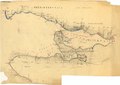 | 8,453 × 5,984 (94.86 MB) | TimBray | Uploaded a work by S. Matthews, City of Vancouver Archivist from City of Vancouver Public Archives with UploadWizard |
File usage
There are no pages that use this file.
Global file usage
The following other wikis use this file:
- Usage on en.wikipedia.org