Diving at Smits Reef

The dive site Smits Reef. also known as Batsata Maze, Birthday Reef, Seekatbank and Horseshoe Reef is a rocky reef in the Smitswinkel Bay area on the False Bay coast of the Cape Peninsula, near Cape Town in the Western Cape province of South Africa. The site includes the outlying Kreef Reef to the nortwest.
Understand[edit]


This reef has a wide variety of colourful invertebrates and spectacular topography in good visibility. There are several parts of the reef which are far enough apart to be dived as separate sites. The Maze is the most popular – a small area with some interleading swimthroughs among the large boulders to the south-east of the reef.
Position[edit]
S34°16.486’ E018°28.929’ 1 Smits Reef (Top of the reef)
The reef is north and offshore slightly from Batsata Rock, and extends into the mouth of Smitswinkel Bay.
This site is in the Table Mountain National Park Marine Protected Area (2004). A permit is required. The reef shown on the map is all just outside the Paulsberg Restricted Zone.
Name[edit]
This area has many names. "Smits Reef" is obvious and logical , as it is in Smitswinkel Bay, and the popular contraction for the wrecks of the area is "Smits wrecks", so Smits Reef makes sense, and is used to refer to the whole area and more specifically to the top of the main reef, on the east side of the gap. "Batsata Maze" refers to the nearby Batsata Rock, but most of the reef is not really much of a maze, so it is recommended that this name is reserved for the small section at the south east corner, centred on S34°16.517' E018°29.017', which is more like a maze than the rest, with deep gullies and gaps between huge boulders, and several caves and swimthroughs. "Birthday Reef" is probably a purely arbitrary reference to an unknown person's birthday, and the relevance is unclear. The name is falling out of general usage. "Horseshoe Reef" refers to the shape of the north eastern part of the reef, which is a massive area of granite with a deep indentation, not entirely unlike a horseshoe in shape, so it is now used when referring to the northeastern sector. The whole area is known to fishermen as "Seekatbank", presumably because of the abundance of octopus (seekat in Afrikaans) caught here. The number seen on dives is not very large, but there are plenty of places for them to hide, so they might well be there. "Western Pinnacles" is the group of shallow pinnacles on the smaller mass of reef to the west of the sand gap.
The large relatively flat and deep northern outlier "Kreef Reef" is named for the large numbers of kreef (west coast rock lobster) seen on the first survey dive. It also has a large number of large sea fans, but there is already a "Fan Reef" in the region.
Depth[edit]
Maximum about 27 m on the sand, top of the highest pinnacle is about 4 m. Most of the Maze is around 15 to 18 m and this would be the average depth for most dives.
Visibility[edit]
Visibility is likely to be similar to that on the Smits Wrecks. 20 m would be exceptionally good, 8 to 10 m good and less than 5 m would be considered poor.
Topography[edit]

The reef is an immense outcrop of granite, with cracks and deep gulleys, and a lot of large boulders, surrounded by sand. To the south the sand is a relatively narrow strip, beyond which is more reef, which extends continuously to Batsata Rock. To the north, lower reef is visible across the sand on a good day. This includes Kreef Reef and the North-Eastern outliers. There is also some low reef near the main reef to the east of the Maze. On the other sides, the sand extends much further, and there does not appear to be much more reef nearby.
The main reef can be considered in several sections: The south end has the maze, the west side has a large number of large boulders, scattered over the bedrock of the lower part of the reef, but does not appear to have many deep overhangs or big holes, with one notable exception where a huge boulder on the reef overhangs a lower section by several metres. The north eastern corner is similar, the northern ridge has relatively steep sides, and a few very deep. narrow cracks, and the sand bottom is deeper than on the west side. The east side from the big northern indentation south east to the Maze is moderately sloped, with fewer big boulders than the west side. The top of the reef is fairly flat over quite large areas in the middle, but also has a few boulder pinnacles and relatively shallow gullies.
Geology: Granite of the Pre-Cambrian Peninsula pluton on a quartz sand bottom with occasional shelly areas.
Conditions[edit]
The site is exposed to swell from the south east, and to a certain extent, from the south west. Longer period swell will make conditions on the reef uncomfortable or hazardous due to strong surge, but short period waves will just make it uncomfortable on the boat. Visibility is less predictable, and at this time is largely a matter of luck and reports from divers who were in the area recently.
The site is usually at it's best in winter but there are also occasional opportunities at other times of the year, though least often in summer, when the south east wind tends to blow much of the time.
Get in[edit]
Only accessible by boat. The site is approximately 5.8 km from Miller's Point slipway and 13.1km from Simon's Town jetty.
Do[edit]
Dive at one of the marks and explore the vicinity. The reef complex is too big to see it all on one dive.
1 Smits Reef: S34°16.486’ E018°28.929’. (Top of the reef) The south west corner of the main reef also has some pretty rugged profile, and the big overhang on the 15 m contour is worth a visit.
2 Batsata Maze: S34°16.517' E018°29.017'. (About the middle of the Maze area.) Batsata Maze is a small section of the reef towards the southeast where a jumble of large boulders lie on top of the lower outcrops and form a group of swim-throughs, overhangs, gaps and caves. There is a relatively complex group of linked swim-throughs and holes under the rocks at a depth of roughly 20 m to the east side of the Maze. The main entrance at S34°16'30.9", E018°29'01.5" faces 120° magnetic (roughly southeast) and is at the northwest end of a fairly deep gap between boulders. The swim-through forks to both sides, but the south fork appears to be bigger. If you follow the 18 m depth contour north from this swim-through, you should find a few others, considerably smaller, in the general vicinity of the Maze. A dive at the Maze will appeal to divers who like overhangs, holes and swim-throughs. Dive on the reef near the south end, Swim south to 20 m depth, and follow the 20 m contour to the cave on the east side of the reef. There are several other holes and swim-throughs in this area and you can easily spend an hour looking for them.
3 Maze Cave: S34°16.517' E018°29.026'. (Main entrance to the cave swim-through)
4 Western Pinnacle: S34°16.495' E018°28.863'. The West Reef is across a sandy bottomed gap from the west side of the main reef. There is a sheer sided pinnacle near the southern end of this section, and a more gradual slope to the sand to the north. The sand bottom in this area is mostly between 17 and 18 m deep. Most of this section is low profile, below the 15 m contour, and the rest is pretty steep, peaking to the south with at least two pinnacles just above 6 m depth on top. The west reef is also quite spectacular, particularly the pinnacle to the south, which rises from near the bottom at about 16 m almost straight up to the flattish top at about 6 m. The northern part of the west reef is much lower and fairly flat in places.
5 Horseshoe Reef: S34°16.410' E018°28.940'. (Northeast pinnacle, on the Northeast Ridge) Horseshoe Reef is the northeastern section, comprising the northern ridge and the east face of the main reef. There are a number of small outliers up to about 4 m high in the inside of the horseshoe curve, and a small group of relatively tall rocks close to the north side of the east end, where the depth of the sand gets down to 27&npbp;m. The northeastern area of the main reef is quite highly profiled in the 12 to 15 m depth range, with fairly steep walls and some overhangs.
6 Kreef Reef: S34°16.360' E018°28.780'. Kreef Reef is a large, relatively low, outlier to the north west of Smits Reef. Mostly low and medium profile rocky reef with outcrops and small boulders. Type of rock is not clear. Granite possible, but heavily jointed and somewhat weathered, probably not more than about 4 m higher than the sand. Lots of broken reef with small boulders and outcrops, giving a diffuse edge to most of the west and north perimeter. Lots of sea fans, particularly palmate sea fans. The reef is about 100 m long north to south and more than 50 m wide east to west. The depth on the sand varies from about 22 m on the west side to more than 24 m on the east side.
An unnamed southern outlier is due south of the main reef, on sand about 24 m deep. There are a few large boulders resting on the relatively low outcrops, and some of these have small gaps underneath. The high point is the largest pinnacle which reaches to about 11 m from the surface. The reef life is similar to the main reef, but a little less diverse due to the smaller depth range. It is a fairly large piece of reef, as can be seen from the map.
See[edit]
Marine life[edit]
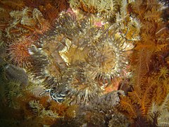
Like many other sites on the False Bay side of the Cape Peninsula, the shallowest areas have large numbers of the large solitary sea squirt known locally as "red bait", The steeper walls tend to be covered in common feather stars, with a scattering of Elegant feather stars and a variety of encrusting and more bulky sponges, false corals, gorgonians. The deeper reef tops have red-chested and Mauve sea cucumbers, gorgonians, strawberry anemones and striped anemones. There are also places where there is a surprisingly dense cover of brittle stars, and cauliflower soft corals can be found scattered around the less exposed areas.
The west reef appears to be notable for the numbers of catsharks and Orange wall sponges seen there. Flatter areas of the deeper rocks tend to have large numbers of sea urchins and sea cucumbers. Hottentot seabream and Galjoen can be seen on the pinnacle.
Smits Reef
-
 Red-Bait on a pinnacle
 -
 Shy shark and brittle stars on a red sponge
 -
 African seabass
 -
 False plum anemone
 -
 Orange wall sponge
 -
 Striped anemones


Kreef Reef
-
 Aggregation of West Coast rock lobster
 -
 Teat sponge at Kreef Reef
 -
 Grey ball sponge at Kreef Reef
 -
 Palmate sea fan at Kreef Reef
 -
 Sinuous sea fan at Kreef Reef
 -
 Bryozoans at Kreef Reef


Features[edit]
- The Maze, to the south of the main reef, with the cave/swimthrough complex at 20 m on the east side at S34°16.516' E18°29.025'.
- The long sandy gully, between the main outcrop and the lesser outcrop to the west.
- The large overhang on the south west side of the main reef at S34°16.499' E18°28.909'
- The pinnacle at the south end of the west reef at S34°16.495' E18°28.863'
- The outlier pinnacles and wall at the east end of the north-east arm
Photography[edit]
Good site for invertebrate photography. (photographic equipment suggestions)
Stay safe[edit]
Hazards[edit]
No site specific hazards are known. Some of the swimthroughs are a bit tight and you should exercise caution and good judgement before entering them. You can not get lost in them, but could get stuck. It is technically an offense to damage the reef life, and other divers tend to object, as this is what we dive to see, so be careful.
Skills[edit]
Appropriate certification for the planned depth is expected, but no special skills are required.
Equipment[edit]
The site is fairly far offshore, so a DSMB is a useful safety feature if it is necessary to surface far from the shot line, which is quite common practice, as it may be difficult to find your way back — it is, after all, called the Maze... A compass will help with navigation and Nitrox can significantly increase no decompression dive time depending on the depth of the dive.
Nearby[edit]

- 1 SAS Transvaal
- 2 MFV Orotava
- 3 Good Hope Reef
- 4 MFV Princess Elizabeth
- 5 SAS Good Hope
- 6 MV Rockeater
- 7 Smits Cliff
- 8 Batsata Rock
Back to the Alphabetical list of sites, or list of dive sites in the Batsata area
Other regional dive sites:
- Dive sites of Table Bay and approaches,
- Dive sites of the Cape Peninsula west coast
- Dive sites of False Bay offshore and approaches
- Dive sites of False Bay east coast
- Fresh water dive sites of the Cape Town Metropolitan Area