Jump to content

Download GPX file for this article
-35.238889173.544444Full screen dynamic map
From Wikivoyage
This is an old revision of this page, as edited by AlasdairW (talk | contribs) at 22:22, 8 August 2018 (Get around).
(diff) ← Older revision | Latest revision (diff) | Newer revision → (diff)

Oceania > New Zealand > North Island > Northland > Hokianga > Mangamuka Bridge

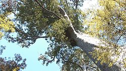
Tall kauri in Omahuta Kauri Sanctuary

Mangamuka Bridge is a small town in Hokianga.

Get in

[edit]

Get around

[edit]
Map
Map of Mangamuka Bridge

See

[edit]
  • 1 Omahuta Kauri Sanctuary (2 km south of Mangamuka Bridge, turn east into Omahuta Road, then after 7 km, turn right onto Sanctuary Road and go to the end). See five of the twelve biggest kauri trees in an undisturbed healthy forest in a reserve established by Dept of Conservation in 1952.

Do

[edit]

Buy

[edit]
  • 1 Mangamuka Dairy, SH1. Dairy selling hot burgers.

Eat

[edit]

Drink

[edit]

Sleep

[edit]

Go next

[edit]
This city travel guide to Mangamuka Bridge is an outline and needs more content. It has a template, but there is not enough information present. Please plunge forward and help it grow!