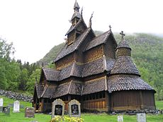
Lærdal is a village, a valley and a district in Sogn og Fjordane. Lærdal village is situated at the end of the Lærdal valley. Lærdal is home to Borgund stave church, one of the best preserved and typical stave church of its kind. The valley is one of the major valleys of the county and cuts deep into the central uplands from Sognefjorden. Lærdal is known for its modest rainfall, fine salmon river and intensive horticulture along the valley floor. Lærdal village is protected by law because of its fine collection of old wooden buildings. Because of its easy access to Eastern Norway by road and to Bergen and Western Norway by boat, Lærdal has always been a hub. The main road between Oslo and Bergen runs through Lærdal, including the world's longest road tunnel, the 25 kilometer long Lærdal tunnel.

Understand

Lærdal is the entire valley stretching from the great Sognefjord to the mountains at Valdres (the Filefjell mountain pass). The village is known as Lærdalsøyri where -øyri ("ayre" in Scotland) refers to the sandbank created at the river mouth (the delta). The village is largely built on this sandbank at the intersection of fjord and valley. The Lærdal river is or used to be one of the prime salmon angling rivers in western Norway. Lærdal and the Filefjell mountain pass is one of the easiest and shortest overland connections between western Norway and the eastern interior, so this was the route for the first national mail service established in the 1600s and also the "King's road" between Oslo and Bergen in 1793 making it possible to drive (horse and carriage) between Norway's principal cities. The Bergen main road, as it was also known, was an engineering achievement and can still be seen in Lærdal valley and on the mountain pass. Because of its convenient location at the intersection of the great fjord and the interior, Lærdal village for centuries hosted the Lærdal fair, the most important trading place outside Bergen. Lærdal still hosts the E16, main road between east and west. The difficult section near Borgund displays several generations of road construction. The current E16 through fast tunnels is the 4th or 5th generation, and replaced a road carved into the rock along the river bend (now local road).

In january 2014 a terrible fire broke in Lærdal village. There was no snow, very dry and a strong easterly wind down the valley. About 60 buildings were damaged, luckily only one of the protected buildings in the traditional wooden architecture was lost. This was the largest fire in Norway for 100 years.
Lærdal is also home to Borgund stave church (not to be confused with Borgund church in Ålesund), the best preserved wooden church from the end of the Viking era. This church is the symbol of Norway's remaining 30 stave churches and the unique heritage of these fragile and complicated buildings.
The are several pretty waterfalls on display along the steep walls of the Lærdal valley, particularly visible in spring or after rain. Stødnafossen above the village is conspicuous. There are also some nice waterfalls through gorges in the main river at Borgund.
Lærdal, particularly a bit up the valley, is the driest area in western Norway, with annual precipitation around 400 to 500 mm. The outer part of Sognefjorden has some five-six times more rainfall.
Get in
By car
Lærdal is on the E16 route. On this route you can reach Lærdal from east from Fagernes in Valdres and Oslo.
Get around
See

- 1 Borgund Stave Church (Borgund Stavkirke), Borgund, ☏ +47 57668109, fax: +47 57668108, borgund@fortidsminneforeningen.no. 1 May-30 Sep: 10AM-5PM, 11 Jun-21 Aug: 8AM-8PM. Built around 1180. It is the best preserved stave church in Norway. Adults: kr 80, Students/Children: kr 60.
- The Norwegian Wild Salmon Centre (Norsk villakssenter), ☏ +47 57666771, fax: +47 57666682, post@norsk-villakssenter.no. May: 10AM-6PM, Jun and Aug: 10AM-7PM, Jul: 10AM-10PM, Sep:11AM-5PM. Gives information about the life of the salamon.
- Vindhella old road.
Do

- Vindhellavegen, Borgund (Starting point by Borgund Stave Church). Walking along the old road.
- Drive Lærdal tunnel, at almost 25 km the longest road tunnel in the world.
Buy
Eat
Drink
Sleep
- 1 Lærdal Hotel, Habnavegen 5, ☏ +47 57666510, fax: +47 57666510, post@lerdalhotel.no. Single: kr 995, Double: kr 1296.
- 2 Lindstrøm Hotel, Øyraplassen 1, ☏ +47 57666900, fax: +47 57666681, post@lindstroemhotel.no. Single: kr 940, Double: kr 1300.
- Offerdal Hotell, ☏ +47 57666101.
- 3 Sanden Pensjonat, Øyragata 9, ☏ +47 57666404, post@sandenpensjonat.no. Single: kr 400-950, Double: kr 450-1050, Apartment: kr 1300.
Connect
Go next

- The mountain road to Aurland, close to Flåm. This road reach an altitude of 1306 m (4285 ft). The road is named the snow road because snow lies beside it throughout the summer. Awesome view over Aurland.
- Valdres or Hallingdal - Lærdal's upland neighbours in the eastern interior
- Flåm
- Luster - the romantic and dramatic eastern part of Sognefjord
| Routes through Lærdal |
| Bergen ← Flåm ← | W |
→ Valdres → Oslo airport |
| Førde ← Sogndal ← | W |
→ Lærdal village (end) |
| Borlaug/Lærdal (end) ← Hemsedal mt pass ← | N |
→ Hemsedal → Hallingdal |
