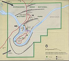
Horseshoe Bend National Military Park is close to Dadeville in Central Alabama. It preserves the site where during the War of 1812, on 27 March 1814, Andrew Jackson led 3,300 troops against a force of around 1,000 Red Stick Creek warriors, about 800 of whom died in the battle.
History
[edit]In March 1814, General Jackson's army left Fort Williams on the Coosa, cut a 52-mile trail through the forest in three days, and on the 26th made camp six miles north of Horseshoe Bend. The next morning, Jackson sent General John Coffee and 700 mounted infantry and 600 Cherokee and Creek allies three miles down-stream to cross the Tallapoosa and surround the bend. He took the rest of the army - about 2000 men, consisting of East and West Tennessee militia and the Thirty-ninth U.S. Infantry - into the peninsula and at 10:30AM began an ineffectual two-hour artillery bombardment of the Red Sticks' log barricade. At noon, Coffee's Cherokee allies crossed the river and assaulted the Red Sticks from the rear. Jackson quickly ordered a frontal bayonet charge, which poured over the barricade. Fighting ranged over the south end of the peninsula throughout the afternoon. By dark at least 800 of Chief Menawa's 1,000 Red Sticks were dead (557 slain on the field and 200-300 in the river). Menawa himself, although severely wounded, managed to escape. Jackson's losses in the battle were 49 killed and 154 wounded, many mortally.
Though the Red Sticks had been crushed at Tohopeka, remnants of the war party held out for several months. In August 1814, a treaty between the United States and the Creek Nation was signed at Fort Jackson near the present day city of Wetumpka, Alabama. The Treaty of Fort Jackson ended the conflict and required the Creeks to cede 23 million acres of land to the United States. The state of Alabama was carved out of this domain and admitted to the Union in 1819.
Landscape
[edit]Horseshoe Bend NMP sits on a large bend in the Tallapoosa River. The surrounding landscape is hilly.
Flora and fauna
[edit]Deer are somewhat common, and wild turkeys can sometimes be seen.
Climate
[edit]Highs of 90 °F (32 °C) to be expected in the summer months. Winters are mild. Be sure to wear sunscreen if hiking or canoeing because the sun can be brutal.
Get in
[edit]
The park is located in east central Alabama on State Highway 49, 12 miles north of the town of Dadeville and about 2 hours from both Birmingham and Atlanta. Signs along U.S. Highway 280 (if coming from Birmingham) and Alabama State Road 22 (if coming from Atlanta) will direct you to the park.
Fees and permits
[edit]There are no entrance or user fees for the park.
Get around
[edit]The 3 mile tour road is a one-way loop with several stops along the way. The park can also be explored by foot.
See
[edit]The visitor's center and tour road have several stops and exhibits explaining the battle and its legacy, as well as Native American history in this part of Alabama.
Do
[edit]The nature trail is 2.8 miles long and winds through the battlefield as well as the site of a Creek Indian camp from the 1800s. Canoeing is popular on the Tallapoosa River, and boats can launch from the ramp about a half mile south and across the river from the visitor's center.
Horseback riding and hunting are not allowed in the park. Fishing is only allowed at the boat ramp, provided you have an Alabama state fishing license.
On the Saturday in March closest to the anniversary of the battle, the park holds living history demonstrations.
Stay safe
[edit]Summer heat is the biggest danger in the park. Watch out for snakes during the warmer months.
Go next
[edit]Wind Creek State Park is about 20 minutes east of Dadeville on the shores of Lake Martin. It has plenty of opportunities for hiking, fishing, and camping.
Cheaha State Park is about an hour north of Horseshoe Bend on AL-49. Mt Cheaha is the highest mountain in Alabama and the park features a variety of hiking trails with great views of the Appalachians, especially amazing at sunset. The park has a very nice lodge near the summit.

