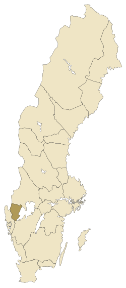
Dalsland is a province in western Götaland in Sweden, with lake Vänern (the largest lake in Sweden and the largest lake in Europe outside Russia) to the east, and Norway to the west. It borders Värmland, Bohuslän and Västergötland.
Understand
[edit]Dalsland is a province off the beaten path. It is varied, with a fertile southeast and southwest, and more hilly otherwise. The northern part have lots of lakes. Dalsland is less populated than the rest of Götaland, with Åmål as its only city. The rest of Dalsland is very rural. What you will find is lots of nature, including some of the few remaining areas of old-growth forest in this part of Scandinavia, large oak woods, hundreds of lakes and ancient burial grounds. The provincial tourism motto for Dalsland, "you will not feel crowded here" is therefore very true.
Municipalities
[edit]Get in
[edit]By car
[edit]E45 is the main route running south-north in Sweden going through eastern Dalsland. To drive from south to Färgelanda, Dals-Ed, or Bengtsfors try road E6 and 172. From Norway, use roads E6, 220 and 166 past Halden to Ed, or E18 and 172 to Bengtsfors.
By public transport
[edit]To go from Karlstad or Gothenburg use SJ trains to Mellerud, Ed or Åmål, and to the other places (except Färgelanda) connecting bus from there. To Färgelanda and also to Ed or Bengtsfors, you can take the Västtrafik train to Uddevalla and use connecting bus. The southeast belongs to Vänersborg municipality, accessed by bus from Vänersborg. In general, search the Västtrafik site for connections.
From the Gothenburg-Landvetter airport, the airport bus to Gothenburg (going directly from the airport building) and then train is preferred. Karlstad and Trollhättan have domestic airports. There you need to take taxi to the railway station. You can also rent a car at any of these airports.
Tickets for Västtrafik can be bought by credit card onboard, but not for buses in Gothenburg. SJ tickets are from machines at the station or prebooked on the web. Pressbyrån and some other shops sell tickets. The airport bus need special tickets which are bought with credit card onboard.
Get around
[edit]Inside the area there are buses. Public transport in the area is organized by Västtrafik.
See
[edit]- 1 Nordiska Tomtemuséet (The Nordic Gnome Museum), Järnvägsgatan 16 (Mellerud), ☏ +46 530-40116, info@nordiskatomtemuseet.com. Daily 10:00-18:00. A museum, cafe and store showcasing some 500 "Tomtar", or gnomes.
Do
[edit]- 1 Dalslands Aktiviteter, Steneby gård (Dals Långed), ☏ +46 531-33086, info@dalslandsaktiviteter.se. An activity centre offering a lot of different actities, such as horseback riding, archery and a moose farm!
Eat
[edit]- 1 Bill's Grill & Mini Mart, Lilla Mossen 120 (Located on the E45 at Animskog 25km North of Mellerud/25km South of Åmal.), ☏ +46 532-250 23. Open 7 days a week. American grill/breakfast.
- 2 Falkholts Dalslandskrog, Norebyn 12 (Dals Långed), ☏ +46 531-350 70, info@falkholt.com. A restaurant in an old school building. Listed in the White guide. A three-course dinner for 525 kr.
- 3 Kupén, Kungsgatan 5 (Åmål), ☏ +46 532-12626, info@cafekupen.se. A cafe, bar and restaurant.
- 4 [dead link] Sunnanå Hamnkrog, Sunnanå hamn 1 (Mellerud), ☏ +46 530-10084, info@sunnanahamnkrog.se.
- 5 Rosellmagasinet, Karlbergsvägen 5 (Bengtsfors), ☏ +46 531-10040, info@rosellmagasinet.com. In a 19th-century warehouse, which is the oldest building in Bengtsfors.
Drink
[edit]Sleep
[edit]
- 1 Baldersnäs Herrgård, Baldersnäs 22, ☏ +46 531-41213, info@baldersnas.com. A mansion turned hotel.
- 2 Dalslands Gästgiveri, Gyltungebyn 810 (Ånimskog), ☏ +46 532-25011, info@dalgast.se.
- 3 First Hotel Bengtsfors, Karlsbergsvägen 3 (Bengtsfors), ☏ +46 531-72700, bengtsfors@firsthotels.se.
- 4 Upperud 9:9, Upperud 9, ☏ +46 70-7498779, info@upperud.se. A hotel and cafe.
- 5 Åmåls Stadshotell, Kungsgatan 9 (Åmål), ☏ +46 532-61610, info@amalsstadshotell.se.
For camping, search camping.se
In Dalsland there are these camping places:
- Ragnerudssjön, 20 km north of Färgelanda, road 172.
- Ursand, 3 km north of Vänersborg, at the coast.
- Sikhall, 10 km north of Vänersborg, at the coast.
- Brålanda, inside Brålanda village, 20 km north of Vänersborg, road E45.
- Kerstins, 2 km west of Mellerud, road E45/166.
- Vita Sandar, 5 km east of Mellerud, road E45
- Örnäs, inside Åmål, road E45.
- Laxsjön, 10 km south of Bengtsfors, 2 km south of Billingsfors, road 172.
- Gröne Backe, near Dals-Ed, road 166.
Stay safe
[edit]See cold weather and driving in Sweden.
Go next
[edit]- Bohuslän – known for its archipelagic coast
- Karlstad – the largest city in Värmland
- Gothenburg – the largest city in western Sweden
- Norway – Fredrikstad and Oslo are not far away
| Routes through Dalsland |
| Göteborg ← Vänersborg ← | S |
→ Säffle → Grums → Karlstad |


