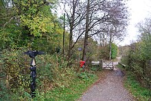
The Forest Way is a country park stretching 16 km along an old rail line through East Sussex.
Understand
[edit]
The 10-mile (16-km) route runs from East Grinstead in West Sussex, through Forest Row just over the border into East Sussex, close to the River Medway in Ashdown Forest towards the Kent village of Groombridge in the east. The path runs along the route of the old East Grinstead to Tunbridge Wells railway. It forms part of National Cycle Route 21, linking up via East Grinstead town centre with the Worth Way to the west. The path passes through many villages, such as Hartfield, from which refreshments are provided in a local pub. Forest Row is a village, with shops and services.
A greater deal of detailed information is available in the form of a PDF from East Sussex County Council.
Prepare
[edit]Have a well maintained bike and a puncture repair kit etc; since there are limited bike shops and at certain times of the day and at certain bits of the route traffic can be a bit sparse.

Get in
[edit]- By car - On road parking is available on Herontye Estate in East Grinstead, near the start of the Forest Way. Parking is available in Forest Row, Hartfield and semi on-road parking is at Groombridge
- By train
- Ashurst Station (on the 'Uckfield Line' from London) is nearby (but is the other side of a hill and not signposted
- Eridge Station (next one down) is signposted to the path and both Forest Row and Groombridge, this part of the route is on (fairly rural roads)
- East Grinstead Station, also from London - the path is signposted from East Grinstead and both the station and the town are around 2.5 miles (mostly uphill) from Forest Row.
- By bus - route 291 passes parallel to the path [dead link] with routes 270 and Countryliner 261 passing through Forest Row Very few (if any) bikes are allowed on buses, horses (other than soft toys) similarly are excluded
Eat and drink
[edit]After all that exercise you'll likely want some food....
- Forest Row Various restaurants and pubs, two supermarkets and a good deal of cafes
- Hartfield just under half way; plenty of food places, also the home of pooh bear
- Anchor Inn, Church Street, ☏ +44 1892 770424. Bar meals and snacks.
- Gallipot Inn, Gallipot Street, ☏ +44 1892 770268. Bar meals and snacks.
- Haywaggon Inn, High Street, ☏ +44 1892 770252. Restaurant.
- Groombridge
- The Crown, The Green, ☏ +44 1892 864742.
- The Junction Inn, Station Road, ☏ +44 1892 864275.
Too much alcohol and bikes don't always mix
Stay safe
[edit]The path is suitable for walkers and horse riders too, but it is recommended that you follow the following points:
- cyclists should give way to walkers, horses and people with disabilities. Please use a bell but be aware that people may not hear or see you.
- horse riders – no galloping please.
- take care crossing nearby roads.
- keep a reasonable speed, and slow down at junctions and bends.
Go next
[edit]The route also links up with the Cuckoo Trail and forms part of the cycle route from London to Paris via Newhaven (National Cycle Path route 21).

