The Ennedi Plateau is a sandstone plateau in Saharan Chad and a ![]() UNESCO World Heritage Site.
UNESCO World Heritage Site.
About 50,000 km2 (19,000 sq mi), a large portion of the Ennedi Plateau, was designated as the Ennedi Natural and Cultural Reserve by the Chadian government in January 2019.
Understand
[edit]
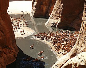
The Ennedi Plateau is as Sahara as Sahara gets. See the camels drink at the gueltas. View the rock paintings. This is Sahara life encapsulated.
The plateau experienced a brief burst in tourism in the late 1990/early 2000s, when French airlines started running tourist routes to Faya. Following jihadist activity in the Sahel, those flights were canceled. The area can now be considered more-or-less untraveled.
See and do
[edit]- Guelta d'Archei Perhaps the most iconic of Saharan waterholes
- Rock art From the second century AD to 1000 AD
Get in
[edit]As of 2023, absent flights to Faya, you'll be booking a tour from N'Djamena. The Ennedi Plateau is usually safer and more stable than, say, the Tibesti Mountains, but regular cautions apply. Always check the prevailing political situation Saharan Chad – searching news sources is a good idea. If things are unstable, don't go, bide your time. Don't rely on your tour operators (who would like your money) to warn you away.

