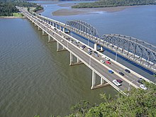
Brooklyn is a small fishing town perched on the banks of the Hawkesbury River, making it one of the most northerly areas of Sydney. As it's south of the Hawkesbury, it's still considered to be a part of Sydney and it and some nearby islands such as Dangar Island are a part of Hornsby Shire Council.
Understand

Brooklyn is a boating mecca on the Hawkesbury River. Geographically in Sydney's Hornsby LGA, being on the south bank of the river, you've got miles of bushland separating this small township from Sydney's suburban sprawl. Constant hum of motorboats coming and going, together with boat ramps, yachts, kayaks and hire boats, make this a busy place on a summer weekend - with long term parking at a premium as people spend a day on the water, or a few nights on a houseboat.
Directly to the south is the expansive Ku-ring-gai Chase National Park; Brooklyn is a key stopover on the Great North Walk.
Get in
By car

It is accessible by the M1 Pacific Motorway from Sydney to Newcastle. It is better to cross the Hawkesbury River on the motorway, take the turning off and head back south again on the adjacent bridge on the B83 Pacific Highway.
Parking is difficult on good days and very hard on weekends and public holidays. There is a 1 larger carpark outside the town about 10 minutes' walk along the shoreline.
By train
2 Hawkesbury River Station on the Sydney to Newcastle line. Despite its name, it's in the middle of Brooklyn town. Some express services do not stop here. It's about 65 minutes from Sydney Central Station.
You cannot walk or bike on the train bridge.
By foot or by ferry
Brooklyn is on the 250km Great North Walk that connects Sydney and Newcastle. You can join the walk at Cowan station, and continue the walk up to Brooklyn (Hawkesbury River Station) for a day walk. Continue from here on the ferry to Little Wobby (to the south of Woy Woy) on the other side of the Hawkesbury River by ferry. There are around half a dozen services a day. There are no roads in to Little Wobby, so you'll have to continue walking on the other side.
By bus
CDC NSW runs route 592 between Cheero Point, Mooney Mooney and Brooklyn. The bus route runs Monday to Saturday (excluding public holidays).
Get around
See
- 1 Brooklyn Marina, Dangar Rd, ☏ +61 2 9985 7722.
Do
- 1 McKell Park, 9 Dangar Rd (Go to the very end of Dangar Rd). A small beach and swimming area enclosed by sharks nets that is shallow enough for young children. There are bathrooms and a large playground next to it.
- 2 Dangar Island. The ferry to Dangar Island leaves hourly. You can take a ferry across and just sit at the wharf coffee shop on the other side and wait for a return. There is also a bowling club here with limited hours, for lunch, dinner and a beer. For a little more activity, you can walk around the island in a couple of hours. It's part bushwalk, part river views, and part observation of the island habitations, which are half hippy style with vege patches and half mansion style with sweeping vistas. Locals are friendly, and you don't half to walk far from the wharf to feel a million kilometres away from everything. $9 each way adult. Kids half price.
- 3 Bush walk. There is a good trek between Brooklyn and Cowan Train Station via Jerusalem Bay. It takes 3-4 hours, and with no facilities or roads on the way you should ensure that you have packed enough water and food. The section heading out of Brooklyn is steep up hill, and requires moderate fitness.
Buy
- 1 Life Boat Seafoods, 1 Dangar Rd, ☏ +61 2 9985 7510. The mullet and chips is their go-to dish.
- 2 River Dreams Gift Shop, 17/9 Dangar Rd, ☏ +61 2 9985 8796.
Eat
- 1 Angler's Rest, 216 Brooklyn Rd, ☏ +61 2 9985 7860. Daily 11:30AM - 8:30PM. The only place you'll find food in town after dark. A nice deck. Live music on Sundays. Accommodation as well. Mains from $20.
- 2 The Teahouse, 2/12 Dangar Rd, ☏ +61 2 9985 7870.
- 3 Fitzies Fish and Chips, 8 Dangar Rd, ☏ +61 2 3280 6905. The closest restaurant to the train station.
Drink
Sleep
- 1 Brooklyn Motel, 7 Bridge St.
- 2 Ripples Houseboats, 7 Brooklyn Rd, ☏ +61 2 9985 5555.
Connect
Go next
- To the south is the Upper North Shore of Sydney, easily accessible by train
- You can walk directly into the Ku-ring-gai Chase National Park from Brooklyn
- To the north is the Central Coast with relaxed coastal communities


