File:2019 - НПП Подільські Товтри - 02.jpg
Jump to navigation
Jump to search

Size of this preview: 800 × 301 pixels. Other resolutions: 320 × 120 pixels | 640 × 241 pixels | 1,024 × 385 pixels | 1,280 × 481 pixels | 2,560 × 962 pixels | 12,590 × 4,732 pixels.
Original file (12,590 × 4,732 pixels, file size: 18.41 MB, MIME type: image/jpeg)
This is a file from the Wikimedia Commons and may be used by other projects. Information from its description page there is shown below.
Commons is a freely licensed media file repository. |
Summary
| Description |
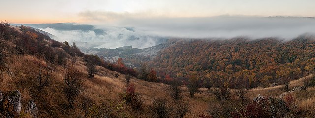
Українська: Подільські Товтри, Кам'янець-Подільський, Чемеровецький, Городоцький райони. Світанок над р. Студениця неподалік села Калачківці, перед впадінням в р. Дністер.
English: The sunrise over Studenycia river, Podilski Tovtry National Nature Park, Khmelnytskyi Oblast, Ukraine.
Русский: Рассвет над рекой Студеница, Национальный парк Подольские Товтры, Хмельницкая область, Украина.
Polski: Rzeka Studenycia, obwód chmielnicki, Ukraina.
Español: Parque nacional natural Podilski Tovtry, Óblast de Jmelnitski, Ucrania.
Čeština: Východ slunce nad údolím řeky Studenycia v národním parku Podilski Tovtry National Nature Park v Chmelnycké oblasti na Ukrajině.
Français : Lever de soleil sur le parc national de Podilski Tovtry dans l'oblast de Khmelnytskyï (Ukraine).
Magyar: Napfelkelte a Sztudenycja folyó felett (Podilszki Tovtri Nemzeti Park, Hmelnickiji terület, Ukrajna)
Македонски: Изгрев над реката Студеница во природниот парк Подолски Татри, Хмелничка област, Украина.
Português: Amanhecer sobre o vale do rio Studenycia, parque nacional natural Podilski Tovtry, região de Khmelnytski, Ucrânia
Эрзянь: Студеница леенть ланга чилисемась, Подолонь Товтрат Раськень вирьпусмо, Хмельницэнь ёнкс, Украина. |
||
| Date | |||
| Source | Own work | ||
| Author | Moahim |
| Camera location | | View this and other nearby images on: OpenStreetMap |
|---|
This image was uploaded as part of Wiki Loves Earth 2019.
|
 |
Assessment
|
This image was selected as picture of the day on Wikimedia Commons for 16 March 2021. It was captioned as follows: English: Sunrise over Studenycia river, Podilski Tovtry National Nature Park, Khmelnytskyi Oblast, Ukraine. Other languages:
Čeština: Východ slunce nad údolím řeky Studenycia v národním parku Podilski Tovtry National Nature Park v Chmelnycké oblasti na Ukrajině. English: Sunrise over Studenycia river, Podilski Tovtry National Nature Park, Khmelnytskyi Oblast, Ukraine. Español: Amanecer sobre el río Studenycia, parque nacional natural Podilski Tovtry, óblast de Jmelnitski, Ucrania. Français : Levé de soleil sur le parc national de Podilski Tovtry dans l'oblast de Khmelnytskyï (Ukraine). Magyar: Napfelkelte a Sztudenycja folyó felett (Podilszki Tovtri Nemzeti Park, Hmelnickiji terület, Ukrajna) Português: Amanhecer sobre o vale do rio Studenycia, parque nacional natural Podilski Tovtry, região de Khmelnytski, Ucrânia Македонски: Изгрев над реката Студеница во природниот парк Подолски Татри, Хмелничка област, Украина. Українська: Світанок над річкою Студениця, Національний природний парк «Подільські Товтри», Хмельницька область, Україна. العربية : شروق الشمس فوق نهر ستادينسيا في منتزه بوديلسكي توفتري الوطني الطبيعي في مقاطعة خملنيتسكي، أوكرانيا. |
Licensing
I, the copyright holder of this work, hereby publish it under the following license:
This file is licensed under the Creative Commons Attribution-Share Alike 4.0 International license.
- You are free:
- to share – to copy, distribute and transmit the work
- to remix – to adapt the work
- Under the following conditions:
- attribution – You must give appropriate credit, provide a link to the license, and indicate if changes were made. You may do so in any reasonable manner, but not in any way that suggests the licensor endorses you or your use.
- share alike – If you remix, transform, or build upon the material, you must distribute your contributions under the same or compatible license as the original.
File history
Click on a date/time to view the file as it appeared at that time.
| Date/Time | Thumbnail | Dimensions | User | Comment | |
|---|---|---|---|---|---|
| current | 19:41, 22 May 2019 | 12,590 × 4,732 (18.41 MB) | Moahim | User created page with UploadWizard |
File usage
There are no pages that use this file.
Global file usage
The following other wikis use this file:
- Usage on alt.wikipedia.org
- Usage on av.wikipedia.org
- Usage on be-tarask.wikipedia.org
- Usage on bn.wikipedia.org
- Usage on crh.wikipedia.org
- Usage on cv.wikipedia.org
- Usage on da.wikipedia.org
- Usage on en.wikipedia.org
- Usage on es.wikipedia.org
- Usage on fr.wikipedia.org
- Usage on gd.wiktionary.org
- Usage on hu.wikipedia.org
- Usage on hy.wikipedia.org
- Usage on id.wikipedia.org
- Usage on it.wiktionary.org
- Usage on ka.wikipedia.org
- Usage on ko.wikipedia.org
- Usage on lbe.wikipedia.org
- Usage on lez.wikipedia.org
- Usage on mk.wikipedia.org
- Usage on os.wikipedia.org
- Usage on pt.wikipedia.org
- Usage on ru.wikipedia.org
- Usage on ru.wikinews.org
- Usage on sah.wikipedia.org
- Usage on uk.wikipedia.org
- Usage on vep.wikipedia.org
- Usage on zh.wikipedia.org