File:AnnotatedGrandfatherFalls-ver02.png
Jump to navigation
Jump to search
Size of this preview: 593 × 600 pixels. Other resolutions: 237 × 240 pixels | 474 × 480 pixels | 688 × 696 pixels.
Original file (688 × 696 pixels, file size: 1.07 MB, MIME type: image/png)
This is a file from the Wikimedia Commons and may be used by other projects. Information from its description page there is shown below.
Commons is a freely licensed media file repository. |
Summary
| Description |
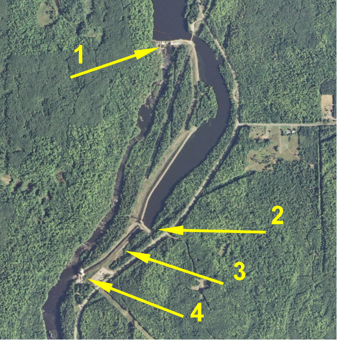
English: Better version of annotated satellite view for article on Grandfather Falls. Background image source is USGS (federal government). Annotations are mine. Satellite view of Grandfather Falls hydro complex. 1: upper dam. 2: penstock intake. 3: penstocks. 4: power house. The distance from the upper dam to the power house is about 1 mile. |
| Date | |
| Source | Own work |
| Author | Jonwurl |
Licensing
I, the copyright holder of this work, hereby publish it under the following license:
This file is licensed under the Creative Commons Attribution 3.0 Unported license.
- You are free:
- to share – to copy, distribute and transmit the work
- to remix – to adapt the work
- Under the following conditions:
- attribution – You must give appropriate credit, provide a link to the license, and indicate if changes were made. You may do so in any reasonable manner, but not in any way that suggests the licensor endorses you or your use.

File history
Click on a date/time to view the file as it appeared at that time.
| Date/Time | Thumbnail | Dimensions | User | Comment | |
|---|---|---|---|---|---|
| current | 16:24, 26 November 2012 | | 688 × 696 (1.07 MB) | Jonwurl | {{Information |Description ={{en|1=Better version of annotated satellite view for article on Grandfather Falls. Background image source is USGS (federal government). Annotations are mine.}} |Source ={{own}} |Author =[[User:Jonwurl|... |
File usage
There are no pages that use this file.
Global file usage
The following other wikis use this file:
- Usage on en.wikipedia.org