File:Crau biome area map-fr.svg
Jump to navigation
Jump to search

Size of this PNG preview of this SVG file: 585 × 600 pixels. Other resolutions: 234 × 240 pixels | 468 × 480 pixels | 749 × 768 pixels | 999 × 1,024 pixels | 1,998 × 2,048 pixels | 995 × 1,020 pixels.
Original file (SVG file, nominally 995 × 1,020 pixels, file size: 698 KB)
This is a file from the Wikimedia Commons and may be used by other projects. Information from its description page there is shown below.
Commons is a freely licensed media file repository. |
Summary
| Camera location | | View this and other nearby images on: OpenStreetMap |
|---|
| Description |
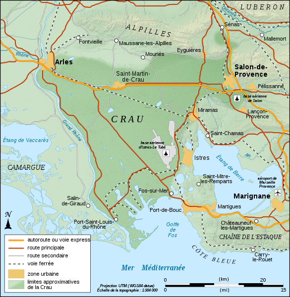
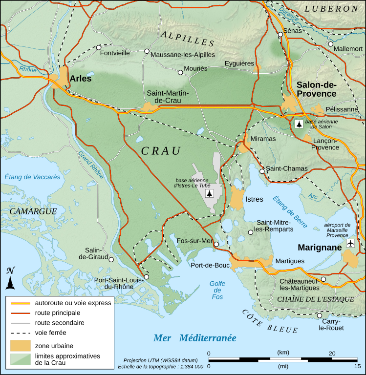
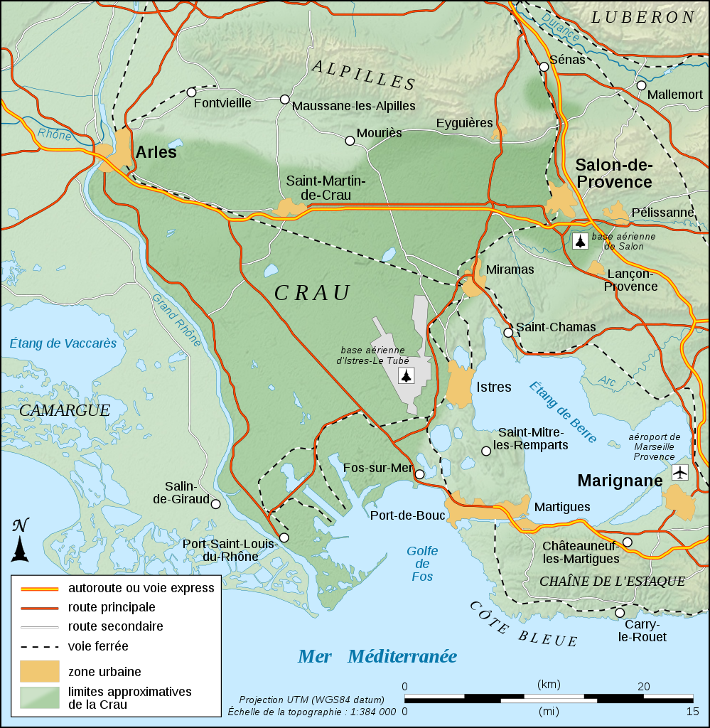
English: Physical map in French of the approximate area of Crau's biome, France.
Note: The background map is a raster image embedded in the SVG file. Français : Carte physique en français des limites approximatives du biome de la Crau, France. Note : Le fond de carte est une image bitmap embarquée dans le fichier SVG. UTM projection ; WGS84 datum ; shaded relief (composite image of N-W, W and N lightning positions) |
||
| Date | |||
| Source |
Own work
|
||
| Author | Eric Gaba (Sting - fr:Sting) | ||
| Permission (Reusing this file) |
|

|
This SVG file contains embedded text that can be translated into your language, using any capable SVG editor, text editor or the SVG Translate tool. For more information see: About translating SVG files. |
Licensing
I, the copyright holder of this work, hereby publish it under the following licenses:

|
Permission is granted to copy, distribute and/or modify this document under the terms of the GNU Free Documentation License, Version 1.2 or any later version published by the Free Software Foundation; with no Invariant Sections, no Front-Cover Texts, and no Back-Cover Texts. A copy of the license is included in the section entitled GNU Free Documentation License. |
This file is licensed under the Creative Commons Attribution-Share Alike 4.0 International, 3.0 Unported, 2.5 Generic, 2.0 Generic and 1.0 Generic license.
- You are free:
- to share – to copy, distribute and transmit the work
- to remix – to adapt the work
- Under the following conditions:
- attribution – You must give appropriate credit, provide a link to the license, and indicate if changes were made. You may do so in any reasonable manner, but not in any way that suggests the licensor endorses you or your use.
- share alike – If you remix, transform, or build upon the material, you must distribute your contributions under the same or compatible license as the original.
You may select the license of your choice.
File history
Click on a date/time to view the file as it appeared at that time.
| Date/Time | Thumbnail | Dimensions | User | Comment | |
|---|---|---|---|---|---|
| current | 12:33, 4 September 2008 | | 995 × 1,020 (698 KB) | Sting | Icons of the air bases |
| 01:49, 20 August 2008 |  | 995 × 1,020 (695 KB) | Sting | Roads classification | |
| 06:51, 19 August 2008 |  | 995 × 1,020 (695 KB) | Sting | + extend of Istres AB's area | |
| 06:37, 19 August 2008 |  | 995 × 1,020 (694 KB) | Sting | More corrections | |
| 06:26, 19 August 2008 |  | 995 × 1,020 (679 KB) | Sting | + 1 air base | |
| 06:07, 19 August 2008 |  | 995 × 1,020 (677 KB) | Sting | Correction ; + airport and air base | |
| 20:43, 18 August 2008 |  | 995 × 1,020 (671 KB) | Sting | == Summary == {{Location|43|34|00|N|04|51|00|E|scale:200000}} <br/> {{Information |Description={{en|Physical map in French of the approximate area of Crau's biome, France.<br/>''Note:'' The background map is a ras |
File usage
There are no pages that use this file.
Global file usage
The following other wikis use this file:
- Usage on de.wikipedia.org
- Usage on en.wikipedia.org
- Usage on fr.wikipedia.org
- Usage on fr.wikinews.org
- Usage on fr.wiktionary.org
- Usage on it.wikipedia.org
- Usage on ja.wikipedia.org
- Usage on nl.wikipedia.org
- Usage on pl.wikipedia.org
- Usage on sq.wikipedia.org
- Usage on www.wikidata.org