File:Drogi krajowe w Polsce.svg
Jump to navigation
Jump to search

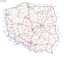
Size of this PNG preview of this SVG file: 682 × 600 pixels. Other resolutions: 273 × 240 pixels | 546 × 480 pixels | 873 × 768 pixels | 1,165 × 1,024 pixels | 2,329 × 2,048 pixels | 3,937 × 3,462 pixels.
Original file (SVG file, nominally 3,937 × 3,462 pixels, file size: 8.29 MB)
This is a file from the Wikimedia Commons and may be used by other projects. Information from its description page there is shown below.
Commons is a freely licensed media file repository. |
Summary
| Description |
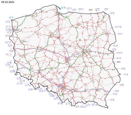
English: Map of national roads in Poland.
Free crossing through a country border (Schengen Area)
Functioning border crossing with non-EU country
Planned border crossing with non-EU country
(with name) - maritime border crossing
National road
National road in construction
National road, dual carriageway
Expressway
Expressway, double carriageway
Expressway, double carriageway under construction
Motorway
Toll motorway
Planned road National road with axle load limit up to 11.5 tonnes per axle
National road with axle load limit up to 10 tonnes per axle
National road with axle load limit up to 8 tonnes per axle
Polski: Mapa sieci dróg krajowych w Polsce.
Swobodne przekraczanie granicy (Układ z Schengen)
Czynne przejście graniczne z krajem spoza Unii Europejskiej
Planowane przejście graniczne z krajem spoza Unii Europejskiej
Oznaczenie morskiego przejścia granicznego
Droga krajowa jednojezdniowa
Droga krajowa jednojezdniowa w budowie
Droga krajowa dwujezdniowa
Droga ekspresowa jednojezdniowa
Droga ekspresowa dwujezdniowa
Droga ekspresowa dwujezdniowa w przygotowaniu/w budowie
Autostrada
Autostrada płatna
Droga planowana Droga krajowa o dopuszczalnym nacisku na oś do 11,5 tony
Droga krajowa o dopuszczalnym nacisku na oś do 10 ton
Droga krajowa o dopuszczalnym nacisku na oś do 8 ton
Deutsch: Die Karte auf Polnischen Autobahnen-, Schnellstraßen- und Landesstraßennetz.
Ehemalige Grenzübergang – „Schengen-Grenze“ (Schengener Abkommen)
Grenzübergang
Geplante Grenzübergang
Übersee Grenzübergang
Einbahnige Landesstraße
Einbahnige Landesstraße im Bau
Zweibahnige Landesstraße
Einbahnige Schnellstraße
Zweibahnige Schnellstraße
Zweibahnige Schnellstraße im Bau
Autobahn
Maut-Autobahn
Geplante Straße Landesstraße mit zulässige Achslasten bis 11,5 Tonnen
Landesstraße mit zulässige Achslasten bis 10 Tonnen
Landesstraße mit zulässige Achslasten bis 8 Tonnen |
| Date | |
| Source | Own work |
| Author | Miko101 |
| Other versions | Derivative works of this file: Drogi EURO2012.svg |
Licensing
I, the copyright holder of this work, hereby publish it under the following license:
This file is licensed under the Creative Commons Attribution-Share Alike 3.0 Unported license.
- You are free:
- to share – to copy, distribute and transmit the work
- to remix – to adapt the work
- Under the following conditions:
- attribution – You must give appropriate credit, provide a link to the license, and indicate if changes were made. You may do so in any reasonable manner, but not in any way that suggests the licensor endorses you or your use.
- share alike – If you remix, transform, or build upon the material, you must distribute your contributions under the same or compatible license as the original.
File history
Click on a date/time to view the file as it appeared at that time.
| Date/Time | Thumbnail | Dimensions | User | Comment | |
|---|---|---|---|---|---|
| current | 20:42, 9 February 2021 | | 3,937 × 3,462 (8.29 MB) | Miko101 | aktualizacja / update |
| 23:59, 24 December 2020 |  | 3,937 × 3,462 (8.27 MB) | Miko101 | aktualizacja | |
| 10:25, 14 August 2020 |  | 3,937 × 3,462 (8.26 MB) | Miko101 | otwarcie autostrady A2 Warszawa – Mińsk Mazowiecki | |
| 19:59, 5 August 2020 |  | 3,937 × 3,462 (8.25 MB) | Miko101 | kolejna aktualizacja, m.in. przedłużenie DK91 z Częstochowy na południe | |
| 22:57, 2 January 2020 |  | 3,937 × 3,462 (8.23 MB) | Miko101 | otwarcie odcinka S5 koło Bydgoszczy, skreślenie DK98 oraz kilka planowanych odcinków dróg | |
| 17:07, 27 December 2019 |  | 3,937 × 3,462 (8.22 MB) | Miko101 | 2019 | |
| 22:39, 25 December 2018 |  | 3,937 × 3,462 (8.18 MB) | Miko101 | aktualizacja/update/die Aktualisierung – 2018 | |
| 14:36, 12 September 2018 |  | 3,937 × 3,462 (8.16 MB) | Musp | poprawiono oznaczenie odcinka A4 w okolicy Gliwic, który jest bezpłatny (objęty stawką zerową) oraz uzupełniono planowany przebieg S52 | |
| 23:26, 1 January 2018 |  | 3,937 × 3,462 (8.16 MB) | Miko101 | aktualizacja, nośność dróg<br/>update, roads capacity per axle<br/>Aktualisierung, Landesstraßen Achslast | |
| 21:55, 4 August 2016 |  | 3,937 × 3,462 (4.76 MB) | Miko101 | aktualizacja (stan na 4.08.2016), większa czytelność mapy |
File usage
The following page uses this file:
Global file usage
The following other wikis use this file:
- Usage on de.wikipedia.org
- Usage on en.wikipedia.org
- Usage on it.wikipedia.org
- Usage on lv.wikipedia.org
- Usage on pl.wikipedia.org
- Usage on pl.wikivoyage.org
- Usage on ru.wikipedia.org
- Usage on uk.wikipedia.org
- Usage on www.wikidata.org