File:Graubünden banner.jpg
Jump to navigation
Jump to search
Size of this preview: 798 × 114 pixels. Other resolutions: 320 × 46 pixels | 2,100 × 300 pixels.
Original file (2,100 × 300 pixels, file size: 272 KB, MIME type: image/jpeg)
This is a file from the Wikimedia Commons and may be used by other projects. Information from its description page there is shown below.
Commons is a freely licensed media file repository. |
Summary
| Description |
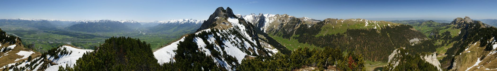
Deutsch: 360° Panorama. Standort: Stauberenfirst auf 1693m. Der Rhein bildet hier die Grenzen zu der Schweiz, Liechtenstein und Österreich. Links im Bild das Bregenzerwalggebirge, dann der Rätikon, die Schweizer Alvierkette. Die Bildmitte zeigt das Gasthaus Staubern mit der Stauberen Chanzeln. In der rechten Bildhälfte der Altmann, und der Säntis im Alpsteingebirge. Der Abschluss rechts mit dem Sendemasten ist der Hohe Kasten. |
| Date | (UTC) |
| Source |
This file was derived from: 360° Staubern Rheintal.jpg: |
| Author |
|
Licensing
I, the copyright holder of this work, hereby publish it under the following license:
This file is licensed under the Creative Commons Attribution-Share Alike 2.5 Generic license.
- You are free:
- to share – to copy, distribute and transmit the work
- to remix – to adapt the work
- Under the following conditions:
- attribution – You must give appropriate credit, provide a link to the license, and indicate if changes were made. You may do so in any reasonable manner, but not in any way that suggests the licensor endorses you or your use.
- share alike – If you remix, transform, or build upon the material, you must distribute your contributions under the same or compatible license as the original.
Original upload log
This image is a derivative work of the following images:
- File:360°_Staubern_Rheintal.jpg licensed with Cc-by-sa-2.5
- 2009-06-03T20:42:04Z Böhringer 8983x1655 (4091421 Bytes) {{Information |Description= {{de| 360° Panorama. Standort: Stauberenfirst auf 1693m. Der Rhein bildet hier die Grenzen zu der [[Schweiz]], [[Liechtenstein]] und [[Österreich]]. Links im Bild das [[:de:Bregenzerwaldgebirge|B
- 2009-05-31T19:45:03Z Böhringer 8983x1655 (12285517 Bytes) {{Information |Description= {{de| 360° Panorama. Standort: Staubernfirst auf 1693m. Der Rhein bildet hier die Grenzen zu der [[Schweiz]], [[Liechtenstein]] und [[Österreich]]. Links im Bild das [[:de:Bregenzerwaldgebirge|Br
File history
Click on a date/time to view the file as it appeared at that time.
| Date/Time | Thumbnail | Dimensions | User | Comment | |
|---|---|---|---|---|---|
| current | 20:10, 19 January 2014 | 2,100 × 300 (272 KB) | Inkey | User created page with UploadWizard |
File usage
There are no pages that use this file.
Global file usage
The following other wikis use this file:
- Usage on ceb.wikipedia.org
- Usage on he.wikivoyage.org
- Usage on it.wikivoyage.org