File:Little Rock National Airport - AR - 25 Mar 2001.jpg
Jump to navigation
Jump to search

Size of this preview: 800 × 554 pixels. Other resolutions: 320 × 221 pixels | 640 × 443 pixels | 1,023 × 708 pixels.
Original file (1,023 × 708 pixels, file size: 209 KB, MIME type: image/jpeg)
This is a file from the Wikimedia Commons and may be used by other projects. Information from its description page there is shown below.
Commons is a freely licensed media file repository. |
Summary
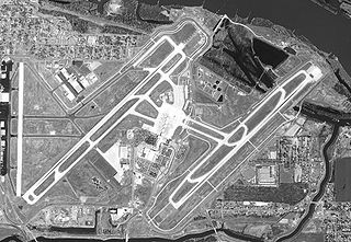
| Description | USGS orthophoto of Little Rock National Airport, Arkansas |
| Date | |
| Source |
USGS The National Map, via MSR Maps (formerly TerraServer-USA) |
| Author | United States Geological Survey (USGS) |
| Permission (Reusing this file) |
Public domain |
Licensing
This image is in the public domain in the United States because it only contains materials that originally came from the United States Geological Survey, an agency of the United States Department of the Interior. For more information, see the official USGS copyright policy.
|
File history
Click on a date/time to view the file as it appeared at that time.
| Date/Time | Thumbnail | Dimensions | User | Comment | |
|---|---|---|---|---|---|
| current | 09:25, 16 April 2008 | | 1,023 × 708 (209 KB) | Bwmoll3 | {{Information |Description=Airpoto of Little Rock National Airport, AR |Source=US Gelological Survey via terraserver http://terraserver-usa.com/map.aspx?t=1&s=12&lon=-92.2069654404153&lat=34.7294630592956&w=800&h=800&opt=0&f=&fs=8&fc=ffffff99&lp=---+None+ |
File usage
The following page uses this file:
Global file usage
The following other wikis use this file:
- Usage on ar.wikipedia.org
- Usage on arz.wikipedia.org
- Usage on ast.wikipedia.org
- Usage on de.wikipedia.org
- Usage on en.wikipedia.org
- Usage on es.wikipedia.org
- Usage on fa.wikipedia.org
- Usage on it.wikipedia.org
- Usage on mr.wikipedia.org
- Usage on no.wikipedia.org
- Usage on ru.wikipedia.org
- Usage on tg.wikipedia.org
- Usage on ur.wikipedia.org
- Usage on www.wikidata.org