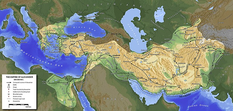
File:MacedonEmpire.jpg
Jump to navigation
Jump to search

Size of this preview: 800 × 382 pixels. Other resolutions: 320 × 153 pixels | 640 × 306 pixels | 1,024 × 489 pixels | 1,990 × 951 pixels.
Original file (1,990 × 951 pixels, file size: 1.86 MB, MIME type: image/jpeg)
File history
Click on a date/time to view the file as it appeared at that time.
| Date/Time | Thumbnail | Dimensions | User | Comment | |
|---|---|---|---|---|---|
| current | 16:26, 8 September 2020 |  | 1,990 × 951 (1.86 MB) | Claude Zygiel | Shorelines of the hellenistic times |
| 12:26, 27 August 2016 |  | 1,990 × 951 (1.79 MB) | Ras67 | cropped | |
| 17:12, 29 January 2016 |  | 2,000 × 961 (1.87 MB) | Ercwlff | Reverted to version as of 19:39, 25 November 2012 (UTC) it's more important what wikipedia article says | |
| 11:25, 22 August 2015 |  | 2,000 × 961 (1.59 MB) | Հայկ Ափրիկյան | Armenia never was captured by Alexander the Great. Sources: *[http://penelope.uchicago.edu/Thayer/E/Roman/Texts/Strabo/11N*.html#ref24 Strabo, Geography: XI, 14. 9] *[https://archive.org/stream/cu31924026460752#page/n451/mode/2up Arrian, The Anabasis o... | |
| 19:39, 25 November 2012 |  | 2,000 × 961 (1.87 MB) | SilvioRusso | corr | |
| 17:33, 25 November 2012 |  | 2,000 × 961 (1.87 MB) | SilvioRusso | +Iberia | |
| 18:47, 13 April 2006 |  | 2,000 × 961 (806 KB) | Captain Blood~commonswiki | A. in Arachosia corr. | |
| 17:38, 24 March 2006 |  | 2,000 × 961 (806 KB) | Captain Blood~commonswiki | {{GFDL-GMT}} |
File usage
The following 2 pages use this file:
Global file usage
The following other wikis use this file:
- Usage on af.wikipedia.org
- Usage on am.wikipedia.org
- Usage on ar.wikipedia.org
- Usage on arz.wikipedia.org
- Usage on ast.wikipedia.org
- Usage on azb.wikipedia.org
- Usage on az.wikipedia.org
- Usage on ba.wikipedia.org
- Usage on be-tarask.wikipedia.org
- Usage on be.wikipedia.org
- Usage on bg.wikipedia.org
- Usage on bn.wikivoyage.org
- Usage on br.wikipedia.org
- Usage on bs.wikipedia.org
- Usage on ca.wikipedia.org
- Usage on ce.wikipedia.org
View more global usage of this file.


