File:Map of Czech railways.gif
Jump to navigation
Jump to search
Size of this preview: 800 × 472 pixels. Other resolutions: 320 × 189 pixels | 640 × 377 pixels | 1,024 × 604 pixels | 1,280 × 755 pixels | 2,000 × 1,179 pixels.
Original file (2,000 × 1,179 pixels, file size: 371 KB, MIME type: image/gif)
This is a file from the Wikimedia Commons and may be used by other projects. Information from its description page there is shown below.
Commons is a freely licensed media file repository. |
Summary
| Description |
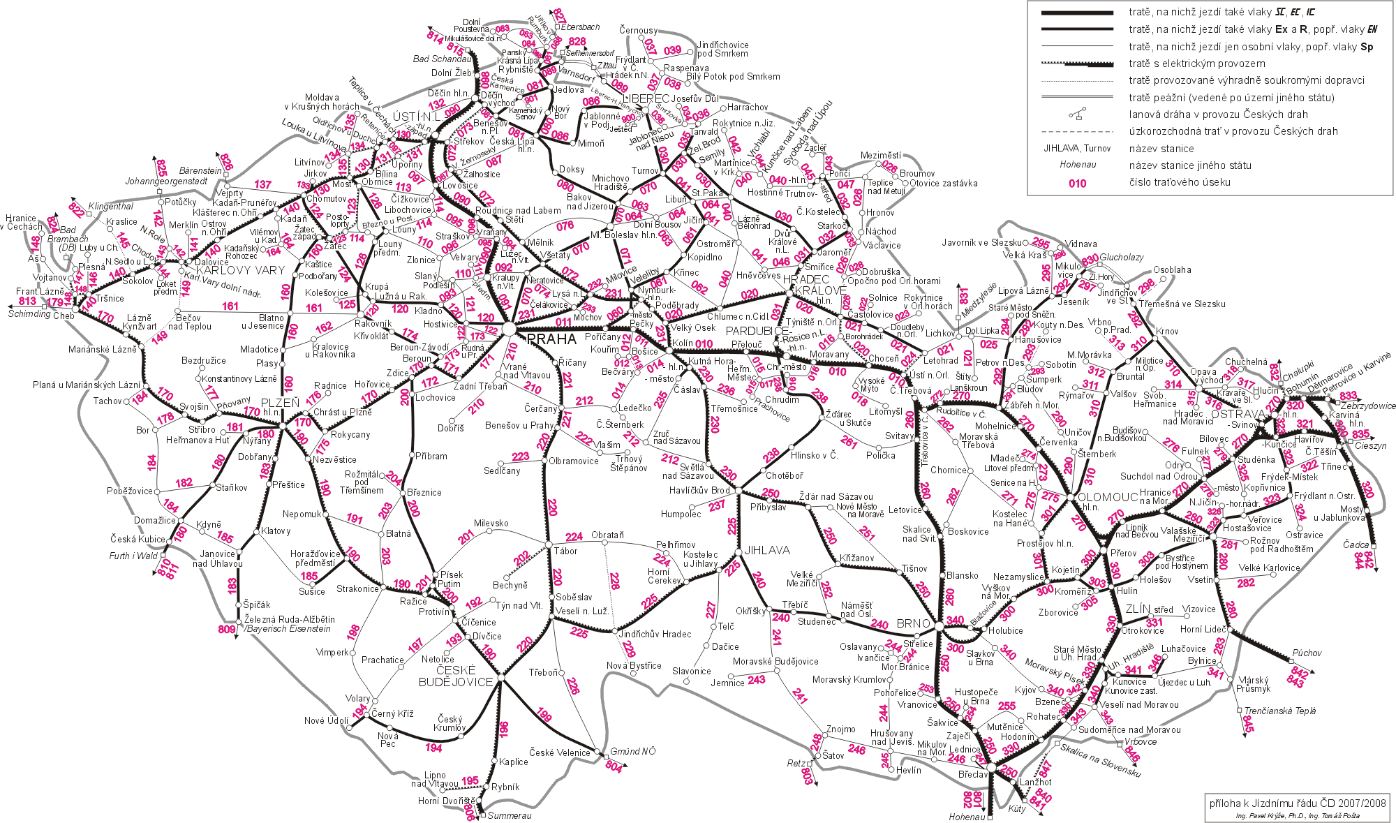
Deutsch: Schienennetzplan der Tschechischen Republik
English: Railway map of Czech Republic
Nederlands: Spoorwegenkaart van Tsjechië
Čeština: Mapa železničních tratí v Česku |
|||
| Date |
|
|||
| Source | http://www.cdrail.cz/cp1250/sluzby/online/kjr_2005.gif (?) | |||
| Author | Czech railway company: České dráhy, a. s., Ing. Pavel Krýže, Ph. D., Ing. Tomáš Pošta | |||
| Permission (Reusing this file) |
||||
| Other versions |
Derivative works of this file: CzechRailwaysBuiltByKleins.gif
|


I sent another e-mail. I received another permission from a employee of the Czech Railway company. I hope it's enough information this time.
Licensing

|
Permission is granted to copy, distribute and/or modify this document under the terms of the GNU Free Documentation License, Version 1.2 or any later version published by the Free Software Foundation; with no Invariant Sections, no Front-Cover Texts, and no Back-Cover Texts. A copy of the license is included in the section entitled GNU Free Documentation License. |
| This file is licensed under the Creative Commons Attribution-Share Alike 3.0 Unported license. | ||
| ||
| This licensing tag was added to this file as part of the GFDL licensing update. |
File history
Click on a date/time to view the file as it appeared at that time.
| Date/Time | Thumbnail | Dimensions | User | Comment | |
|---|---|---|---|---|---|
| current | 11:16, 25 June 2008 | | 2,000 × 1,179 (371 KB) | Erwin1990 | {{Information |Description={{en|1=Railway map of Czech Republic}} {{nl|1=Spoorwegenkaart van Tsjechië}} |Source=http://www.cdrail.cz/cp1250/sluzby/online/kjr_2005.gif |Author=Czech railway company: České dráhy, a.s. |Date=2005 |Permission={{OTRS pendi |
File usage
There are no pages that use this file.
Global file usage
The following other wikis use this file:
- Usage on de.wikivoyage.org
- Usage on en.wikipedia.org
- Usage on eo.wikipedia.org
- Usage on hu.wikipedia.org
- Usage on ja.wikipedia.org
- Usage on nl.wikipedia.org
- Usage on vi.wikipedia.org