File:Onondaga Village historic marker, Seneca Street at Ridge Road, West Seneca, New York - 20210918.jpg
Jump to navigation
Jump to search
Size of this preview: 800 × 480 pixels. Other resolutions: 320 × 192 pixels | 1,024 × 614 pixels | 1,280 × 768 pixels | 2,560 × 1,536 pixels | 4,032 × 2,419 pixels.
Original file (4,032 × 2,419 pixels, file size: 4.31 MB, MIME type: image/jpeg)
This is a file from the Wikimedia Commons and may be used by other projects. Information from its description page there is shown below.
Commons is a freely licensed media file repository. |
Summary
| Description |
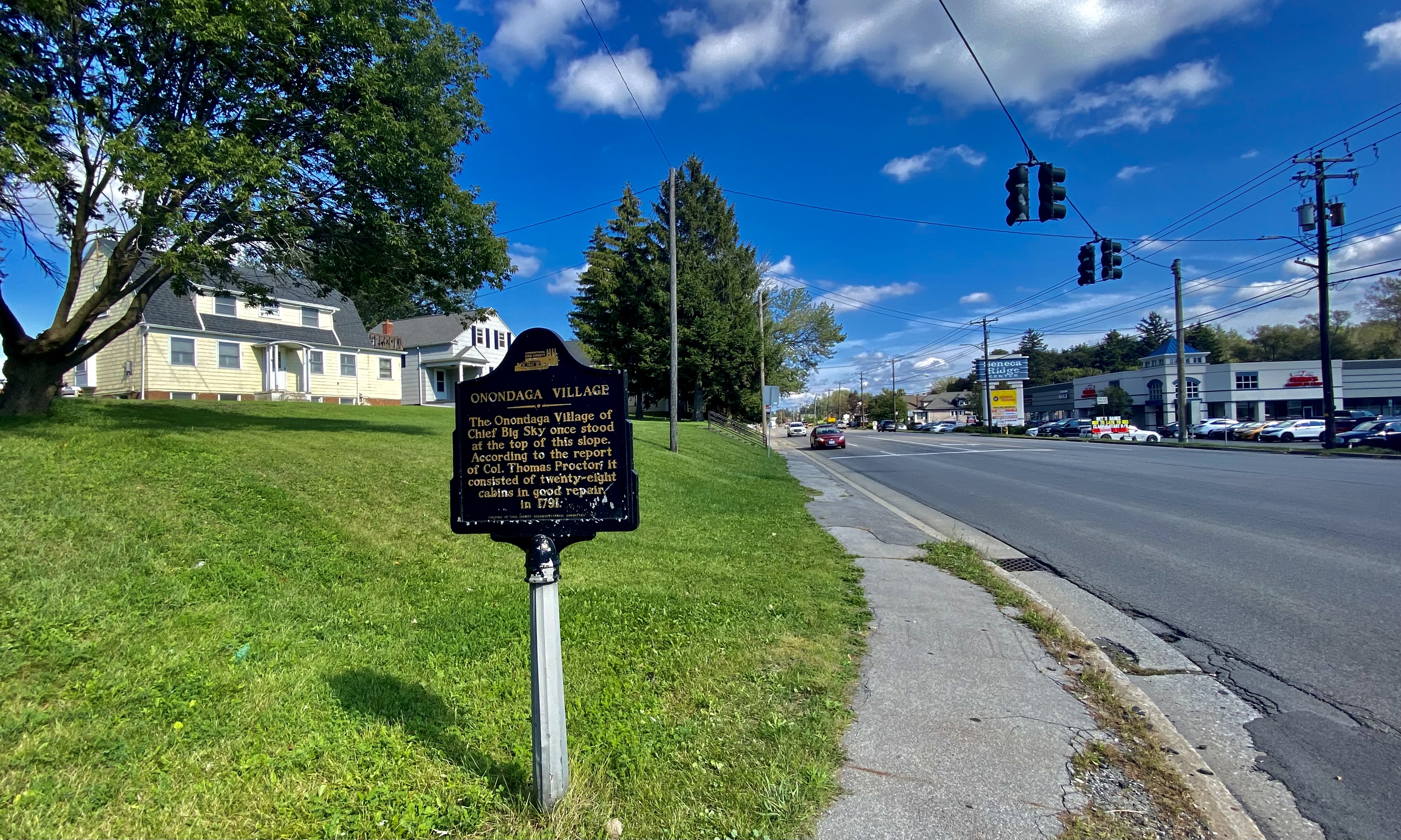
English: As seen in September 2021, a historic plaque marks the crest of the low hill at the northeast corner of Seneca Street and Ridge Road in West Seneca, New York as the former site of the Onondaga village of Chief Big Sky, which "consisted of twenty-eight cabins in good repair in 1791". Though Erie County was not initially Onondaga territory, the region served as a refuge for many survivors of the bloody Sullivan-Clinton Expedition of 1779, an American Revolutionary War campaign during which its namesakes, Major General John Sullivan and Brigadier General James Clinton of the Continental Army, marauded through the Iroquois territory of Central New York in retribution for attacks carried out by them and their British and Loyalist allies against Patriot separatists in Cobleskill, Wyoming Valley and Cherry Valley. The fate of Big Sky's village is unrecorded, but at the time almost the entirety of West Seneca was contained within the Buffalo Creek Reservation of the Seneca Nation (allies of the Onondaga), which was dissolved in 1842. |
| Date | |
| Source | Own work |
| Author | Andre Carrotflower |
| Other versions |
| Camera location | | View this and other nearby images on: OpenStreetMap |
|---|
Licensing
I, the copyright holder of this work, hereby publish it under the following license:
This file is licensed under the Creative Commons Attribution-Share Alike 4.0 International license.
- You are free:
- to share – to copy, distribute and transmit the work
- to remix – to adapt the work
- Under the following conditions:
- attribution – You must give appropriate credit, provide a link to the license, and indicate if changes were made. You may do so in any reasonable manner, but not in any way that suggests the licensor endorses you or your use.
- share alike – If you remix, transform, or build upon the material, you must distribute your contributions under the same or compatible license as the original.
File history
Click on a date/time to view the file as it appeared at that time.
| Date/Time | Thumbnail | Dimensions | User | Comment | |
|---|---|---|---|---|---|
| current | 15:59, 27 September 2021 | | 4,032 × 2,419 (4.31 MB) | Andre Carrotflower | Uploaded own work with UploadWizard |
File usage
There are no pages that use this file.