File:Shinkansenmap.png
Jump to navigation
Jump to search

Size of this preview: 584 × 599 pixels. Other resolutions: 234 × 240 pixels | 468 × 480 pixels | 749 × 768 pixels | 998 × 1,024 pixels | 1,345 × 1,380 pixels.
Original file (1,345 × 1,380 pixels, file size: 239 KB, MIME type: image/png)
This is a file from the Wikimedia Commons and may be used by other projects. Information from its description page there is shown below.
Commons is a freely licensed media file repository. |

| Description |
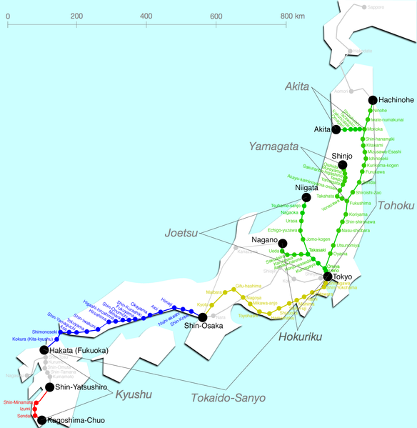
English: Map of Shinkansen network.
Please don't use this image because this includes some errors.
Deutsch: Streckennetz des Shinkansen
Suomi: Kartta, johon Tōkaidō Shinkansen on merkitty keltaisella.
Italiano: Shinkansen mappa delle linee
Nederlands: Kaart van de lijnen
Polski: Mapa sieci kolejowej Shinkansen |
||
| Date | Unknown date | ||
| Source | en:Image:Shinkansenmap.png | ||
| Author | Sekicho | ||
| Permission (Reusing this file) |
|
||
| Other versions | de:Bild:Shinkansen-Liniennetz.jpg |

|
This transport map image could be re-created using vector graphics as an SVG file. This has several advantages; see Commons:Media for cleanup for more information. If an SVG form of this image is available, please upload it and afterwards replace this template with
{{vector version available|new image name}}.
It is recommended to name the SVG file “Shinkansenmap.svg”—then the template Vector version available (or Vva) does not need the new image name parameter. |
File history
Click on a date/time to view the file as it appeared at that time.
| Date/Time | Thumbnail | Dimensions | User | Comment | |
|---|---|---|---|---|---|
| current | 23:52, 6 December 2005 | | 1,345 × 1,380 (239 KB) | Wiki-vr | *Map of Shinkansen network *Karte des japanischen Shinkansen-Netzes *source: en:Image:Shinkansenmap.png *info added {{PD}} Category:Maps of Japan Category:Railroad map of Japan category:Shinkansen |
File usage
The following page uses this file:
Global file usage
The following other wikis use this file:
- Usage on en.wikipedia.org