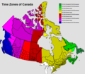
File:UTC hue4map CAN-en.PNG
Jump to navigation
Jump to search

Size of this preview: 685 × 599 pixels. Other resolutions: 274 × 240 pixels | 549 × 480 pixels | 878 × 768 pixels | 1,171 × 1,024 pixels | 1,388 × 1,214 pixels.
Original file (1,388 × 1,214 pixels, file size: 156 KB, MIME type: image/png)
File history
Click on a date/time to view the file as it appeared at that time.
| Date/Time | Thumbnail | Dimensions | User | Comment | |
|---|---|---|---|---|---|
| current | 16:29, 9 March 2020 |  | 1,388 × 1,214 (156 KB) | ノコノコ2015 | Yukon Territory |
| 09:55, 8 August 2016 |  | 1,388 × 1,214 (107 KB) | Heitordp | Updated Northern Rockies | |
| 01:59, 21 January 2016 |  | 1,388 × 1,214 (107 KB) | Demokra | Updated the Newfoundland/SE Labrador timezone colour. Previously it was almost exactly the same colour as the adjacent time zone. This is a common problem in 'hue4map'. | |
| 05:36, 10 January 2016 |  | 1,388 × 1,214 (107 KB) | Heitordp | Updated Northern Rockies | |
| 17:55, 28 May 2012 |  | 1,388 × 1,214 (127 KB) | Phoenix B 1of3 |
File usage
The following page uses this file:
Global file usage
The following other wikis use this file:
- Usage on cs.wikipedia.org
- Usage on fr.wikivoyage.org
- Usage on ja.wikipedia.org
- Usage on uk.wikipedia.org
- Usage on ur.wikipedia.org
- Usage on zh-yue.wikipedia.org
- Usage on zh.wikipedia.org