File:Yzerfontein.JPG
Jump to navigation
Jump to search

Size of this preview: 800 × 420 pixels. Other resolutions: 320 × 168 pixels | 640 × 336 pixels | 1,024 × 538 pixels | 1,280 × 672 pixels | 2,592 × 1,361 pixels.
Original file (2,592 × 1,361 pixels, file size: 1.44 MB, MIME type: image/jpeg)
This is a file from the Wikimedia Commons and may be used by other projects. Information from its description page there is shown below.
Commons is a freely licensed media file repository. |
Summary
| Description |
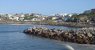
English: The town of Yzerfontein in South Africa, seen from the harbour |
| Date | |
| Source | Own work |
| Author | Zaian |
| Camera location | | View this and other nearby images on: OpenStreetMap |
|---|
Licensing
| I, the copyright holder of this work, release this work into the public domain. This applies worldwide. In some countries this may not be legally possible; if so: I grant anyone the right to use this work for any purpose, without any conditions, unless such conditions are required by law. |
File history
Click on a date/time to view the file as it appeared at that time.
| Date/Time | Thumbnail | Dimensions | User | Comment | |
|---|---|---|---|---|---|
| current | 19:59, 29 December 2009 | | 2,592 × 1,361 (1.44 MB) | Zaian | {{Information |Description={{en|1=The town of Yzerfontein in South Africa, seen from the harbour}} |Source={{own}} |Author=Zaian |Date=2009-12-28 |Permission= |other_versions= }} {{location|33|20|44.66|S|18|8|54.22|E|region:ZA_heading:ESE}} |
File usage
The following 4 pages use this file:
Global file usage
The following other wikis use this file:
- Usage on af.wikipedia.org
- Usage on ceb.wikipedia.org
- Usage on de.wikipedia.org
- Usage on en.wikipedia.org
- Usage on fr.wikipedia.org
- Usage on it.wikipedia.org
- Usage on nso.wikipedia.org
- Usage on pl.wikipedia.org
- Usage on pt.wikipedia.org
- Usage on ru.wikipedia.org
- Usage on ur.wikipedia.org
- Usage on www.wikidata.org
- Usage on zh.wikivoyage.org
- Usage on zu.wikipedia.org