Ciudad Satelite, or simply "Satelite", is part of the metropolitan area of Mexico City. Although there is a specific borough bearing that name, locals refer to Satelite to a broader area including other boroughs or colonias that are located right after crossing the city limits of the Distrito Federal into the State of Mexico. Those Colonias are mainly in three municipalities of the state: Naucalpan, Tlalnepantla, and Atizapan.
Understand
[edit]
Ciudad Satelite was established in the late 1950s as a middle to upper class residential neighborhood. As the city continued to grow, the neighborhood and other nearby old towns became part of the greater area of Mexico City.
In the municipalities of Naucalpan and Tlalnepantla there are several industrial parks where many multinationals have factories, therefore if you come for business travel Ciudad Satelite is a good choice for a break to have lunch or hang out.
Get in
[edit]There is no Metro reaching Ciudad Satelite therefore the best way to reach is by bus or microbus that depart from Metro stations Chapultepec station (Line 1, pink), Rosario (Lines 6: Red and 7: orange) or Cuatro Caminos (also known as Toreo) (Line 2, blue). An alternative is taking a taxi.
If traveling by car, be patient: the main highway known as "Periferico" is practically jammed around the clock, day and night, with average speeds of no more than 10 km/h. A ride from Polanco to Plaza Satelite can take you up to 2 hours in rush hours. Although there is some relief if you travel against the traffic flow (north to south in the morning and backwards in the evening), there is no guarantee that you can reach your destination in time so take your precautions.
See
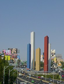
[edit]- 1 Torres de Satelite. Designed by famous Mexican architect Luis Barragan and built in 1957 represent another landmark in Mexico City.
Do
[edit]There is not much to do in Ciudad Satelite as it is mainly a residential area. In spite of that, two of the most important shopping malls in the metropolitan area of Mexico can be visited: Plaza Satélite and Mundo E, the last one with a great variety of restaurants, night clubs and entertainment establishments. Different pubs and bars in Satelite are popular amongst the youth and you can be surprised by the low prices of alcohol compared to the establishments in central Mexico city.
Los Remedios is an antique basilic and one of the oldest in all the country, its a nice spot to visit and the little town there is exceptional to bargain if you are in search of local art.
In the municipalities of Naucalpan and Tlalnepantla there are several industrial parks where many multinationals have their factories, therefore if you come on business travel Ciudad Satelite is a good choice for a break to have lunch or hang out.
- 1 Los Remedios National Park (Parque Nacional Los Remedios), Calle Morelos Manzana 007, Bosque de los Remedios, ☏ +52 55 5560 1732. 05:00 - 18:00. Popular park for jogging, working out, horseback riding and dog walking. About 900 hectares, mostly wooded with wide, marked trails.

- 2 Parque Naucalli, Perif. Blvd. Manuel Ávila Camacho Manzana 020, Boulevares. 07:00 - 18:00. State park with picnic areas, walking trails, skatepark, vendors, dinosaur exhibit. Occasional special events like a Christmas market.
Buy
[edit]- Plaza Satelite. Located in the heart of Ciudad Satelite is one of the largest shopping malls in Mexico City, including anchor stores Liverpool, Sears and El Palacio de Hierro as well as many smaller stores, a fast-food court and cinemas.
- Mundo E. It was conceived as an entertainment dedicated center. It has many small boutiques, cinemas, bars, a dance club, and a sports club.
Eat
[edit]- Chilis
- La Mansion
- Chazz Hamburgers
- Vips
- Sanborn's
- La Cantina de Mexico Lindo y Que Rico
Drink
[edit]Most of bars and small dance clubs are in the Circuito Comercial, near Plaza Satelite.
- Irish Pub, in Sentara Mall (Perif. Blvd. Manuel Ávila Camacho 1434, San Andres Atenco, 54040 Tlalnepantla). Lots of stouts, porters, dunkels, ales, and comfort food.
Sleep
[edit]- Fiesta Inn Naucalpan (near Naucalpan Industrial Park).
- Maria Barbara Hotel.
- Camino Real Tlalnepantla.
Connect
[edit]Cell phone services throughout Mexico City are excellent. 5G coverage is the norm as of 2023, particularly with Telcel, and dark spots with no coverage are virtually unheard of. Free WiFi is available at most hotels, restaurants and other tourist spots. The city government provides free WiFi service to everyone in public parks and plazas.

