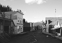
Wells (population 217 in 2016) is a small mining and tourist town in the Cariboo region of British Columbia. Barkerville is a ghost town 8 km (5.0 mi) east of Wells. It was the main centre of Cariboo Gold Rush, and the northern terminus of the Cariboo Wagon Road.
Understand
[edit]Barkerville was the main town of the Cariboo Gold Rush in and is preserved as a historic town. It is located on the north slope of the Cariboo Plateau near the Cariboo Mountains east of Quesnel. Most visitors to Barkerville stay or camp overnight in Wells, although it is also accessible from Quesnel (1 hr 5 min by car).
History
[edit]
Barkerville is named after Billy Barker, who was among those who first struck gold at the location in 1861. His claim was the richest and the most famous. Barkerville was built up almost overnight as word of Barker's strike spread, and by the mid-1860s it had a population of approximately 5,000. By the turn of the century, the town was dying as the gold rush was over. In 1957, the government of British Columbia decided that the town should be restored and operated as a tourist attraction. The few remaining residents were either bought out or moved to nearby communities such as New Barkerville or Wells. Barkerville is a national historic site.
Wells began as a company town, managed by Cariboo Gold Quartz Mine. Fred M. Wells, for whom the town was named, prospected in the area before finding the minerals that built the company. At its heyday of the 1930s, Wells was home to 4,500 people, and in 1942 it had a greater population than Quesnel or Prince George. The closure of the gold and other mineral mines in 1967 took its toll on the town, and most of the population moved away.
Climate
[edit]Barkerville is 700 m above Quesnel, so expect considerably colder weather in spring or autumn, and dress accordingly.
Get in
[edit]By car
[edit]Wells and Barkerville are 80 km (50 mi) east of Quesnel on Highway 26.
Get around
[edit]By public transit
[edit]- BC Transit (Quesnel Transit System), ☏ +1 250-992-1109. Operates Route 30 on Thursdays only between Quesnel and Wells. There is one return trip in the morning and one return trip in the afternoon. $5 one-way (children 12 and under free).
See
[edit]- 1 Barkerville Historic Town and Park, Barkerville, toll-free: +1-888-994-3332 ext 0, barkerville@barkerville.ca. Living history museum of Barkerville with a streetscape of more than 125 heritage buildings, authentic displays, satellite museums, restaurants, shops and accommodations. Barkerville is considered the largest living-history museum in western North America. Open seasonally. 2-day regular admission: adults $16; seniors (60+), teens (13-18) & students $13; youth (6-12) $6; children (5 & under) free; family (2 adults + 4 people under 18) $40.
Do
[edit]

During the winter months, visitors come for the world-class cross-country ski trails, snowmobiling, and artistic and study retreats. During the summer visitors enjoy galleries and live performances.
Nearby
[edit]- 1 Bowron Lake Provincial Park. The Bowron Lakes canoe route is a 116 km (72 mi) canoe and kayak route through a chain of lakes, rivers and creeks linked by portages between the lake. The 7-10 day trip is for experienced back-country paddlers and requires proper planning, physical fitness, equipment and food.
Buy
[edit]Eat
[edit]- 1 Lung Duck Tong Restaurant, Barkerville, ☏ +1 250-994-3458.
Drink
[edit]Sleep
[edit]- 1 The Kelly and King House Bed & Breakfasts, Main St, Barkerville, ☏ +1 250-994-3328, stayinbarkerville@gmail.com. Restored homes in the heart of Barkerville Historic Town & Park.
- 2 St. George Hotel, Barkerville, ☏ +1 250-994-2345, history@stayinbarkerville.ca. An authentic 1890s atmosphere while providing guests with modern amenities. starting at $125 per might.
- 3 The Wells Hotel, Wells, ☏ +1 250-994-3427, whotel@goldcity.net.
- 4 Willow River Inn, Wells, ☏ +1 250-994-2345. Historic hotel in Wells.
There are numerous campgrounds in the Barkerville-Wells area.
Connect
[edit]Go next
[edit]| Routes through Wells-Barkerville |
| END ← Quesnel ← | W |
→ END |

