Abita Springs is a town in Louisiana, in the Piney Woods of St. Tammany Parish, part of the Lake Pontchartrain North Shore area. It's 10-minutes drive east of Covington, an hour east of Baton Rouge, and an hour north of New Orleans.

Get in
[edit]Access is almost exclusively by private vehicle. From I-12, head north on US-190 to Covington. Then take SR-36 east to Abita Springs.
Get around
[edit]See
[edit]- Abita Springs Brewery, 166 Barbee Rd, toll-free: +1-800-737-2311 ext 2. Sa 1PM and 2:30PM, Su 1PM. The brewery tours include free samples of the brewery's local beers. On Highway 36, just west of town towards Covington. free.
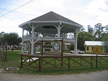
- 1 Abita Springs Tourist Park. The park features the Abita Springs Pavilion, a large, two-story pavilion once sheltering a spring, built in 1884. It is at the west end of Main St. The park remains open and has a playground and picnic areas. The Abita River runs through it. It is the sight of the Abita Spring Water Festival each October.
- Abita Springs Trailhead Museum, 22044 Main St. Su 11AM–3PM. Free.
- UCM Museum / Mystery House, 22275 Hwy 36. A uniquely weird collection of folk-art, curiosities, and (let's face it) old junk, entertainingly arranged and displayed.
Do
[edit]- Insta-Gator Ranch & Hatchery, 74645 Allen Rd (7 minutes drive north east of town). Working alligator farm.
Buy
[edit]Eat
[edit]- Abita Brew Pub, 72011 Holly Street. Tu-Su lunch & dinner.
Drink
[edit]- 1 Abita Springs Brewpub, 21084 Hwy 36, ☏ +1 985-892-5837. Daily 11AM-10PM. A full restaurant and pub, offering samples of Abita brews (including their non-alcoholic root beer) and a gift shop.
- Rosie's Tavern, 22067 Hwy 59 (right by the Pavilion park), ☏ +1 985-809-0454.
Sleep
[edit]- Abita Springs RV Resort, 24150 LA-435, ☏ +1 985-590-3926. Cabins/cottages/campground along lake, with a pool and lounge to engage with other travelers.
Connect
[edit]Go next
[edit]- Covington – 10-minutes drive west
- Mandeville – on the lake, 15-minutes drive south
- Slidell – 30-minutes drive southeast
- Baton Rouge
- New Orleans

