Diving at Three Kings Islands


This article is intended to provide the already qualified scuba diver with information which will help to plan dives in the waters of the Three Kings Islands of New Zealand. The information may not be up to date, and is not complete. Use it at your own risk.
Understand
[edit]
The Three Kings Islands is a small archipelago of 13 islands about 55 km (34 mi) to the northwest of Cape Reinga, the northwesternmost point of North Island, New Zealand. The archipelago consists of two groups: To the west, the small islands, West Island, Princes Islands and Southwest Island, and to the east, Great Island and Northeast Island. They are on the Three Kings Bank which is separated from the New Zealand mainland by an 8-km-wide, 200- to 300-m-deep trough.
The islands are called Manawa-tawhi or Ngā Motu Karaka in Māori. They were named Drie Koningen Eyland by Dutch explorer Abel Janszoon Tasman in 1643 on 6 January, the date on which the visit of the biblical three kings to the Christ child is celebrated.
Three Kings Island is a nature reserve administered by the Department of Conservation.
General topography
[edit]The islands have a land area of about 4.86 km².
They are situated where the South Pacific Ocean and Tasman Sea converge, in two groups, with four main islands and a number of smaller rocks.
King Group
- Great Island or King Island, known to Māori as Ohau or Manawatawhi, is the largest by far with an area of 4.04 km². The island reaches a height of 295 m.
- North East Island, about 1 km northeast of Great Island has an area of 0.10 km² and reaches a height of 111 m.
- Farmers Rocks, 0.8 km east of Great Island, are 5 meters high and just a few hundred square meters in size.
Southwest Group
- South West Island is the second largest of the Three Kings Islands with an area of 0.38 km² and height of 207 m. It is about 4.5 km southwest of Great island.
- The Princes Islands comprise seven small islets and a large number of rocks with a total area of about 0.2 km². They extend from about 600 m west of South West Island for about 1.8 km further west. The north-eastern islet is the highest at 106 m. The smallest islet is Rosemary Rock.
- West Island is the third largest island, with an area of 0.16 km². It is about 500 m southwest of the Princes Islands and is 177 m high.
Climate, weather and sea conditions
[edit]The islands are exposed to wind and swells from all directions, but are slightly sheltered from south easterly swells by the bulk of North Island. The Islands are small and rainwater runoff will not carry much silt into the water, so the visibility is generally good. There are not many good anchorages — the ground is usually boulders and bedrock, so the anchor may hold well enough, but can easily foul.
Water temperature may be as low as 14°C
Marine ecology
[edit]Although the water temperature is more characteristic of temperate waters, the fish and invertebrates include several tropical species, as is the case for several of the offshore island groups of the east coast of North Island, which is in the path of the East Auckland current.
Equipment
[edit]Standard recreational diving equipment is appropriate for most dives. Wet suits are sufficient most of the time, but for long dives a dry-suit may be preferable if the water is cold.
Dive sites
[edit]
South West Island
[edit]Halfway Bay
[edit]- Position: — S34°10.563', E172°04.483'
South West Island
[edit]- Position: — S34°10.547', E172°03.068'
Princes Islands
[edit]Lion Rock
[edit]- Position: — S34°10.605' E172°03.475'
Arch Reef
[edit]- Position: — S34°10.503' E172°02.645'
West Island
[edit]Elingamite Wreck
[edit]The wreck of the Elingamite which foundered on 9 November 1902.
- Position: — S34°11.126' E172°01.875'
North East Island
[edit]North East Island
[edit]- Position: — S34°07.974' E172°09.946'
Great Island (Manawa Tawhi)
[edit]Great Island Northwest
[edit]- Position: — S34°08.812' E172°08.594'
South East Bay
[edit]- Position: — E34°09.213' E172°08.788'
Crater Bay
[edit]- Position: — S34°08.932' E172°07.309'
Cascade Bay
[edit]- Position: — S34°10.007' E172°08.057'
Tasman Bay
[edit]- Position: — S34.15394° E172.14585°
Respect
[edit]The islands are a nature reserve, and a permit from the Department of Conservation is required to go ashore.
The island group is also of cultural importance to the Maori.
Get help
[edit]Emergency services All emergency services are on the mainland, as the islands ere uninhabited.
- . Police.
- . Ambulance service
- . Sea rescue
- . Recompression chamber
- . DAN hotline
Getting there
[edit]The islands are uninhabited. Access is only possible by boat from the mainland.
Get around
[edit]The islands are uninhabited. Diving is on day trips from the mainland or from live-aboard boats.
Stay safe
[edit]See
[edit]
 Sea cucumber
 Trevally
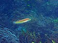 Scarlet wrasse
 Sea anemone
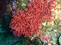 Red seaweed
 Red rock lobster
 Pink ball sponge
 Nudibranch egg mass
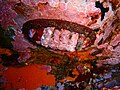 Noble chiton
 Kina sea urchins
 Cup corals
 Crustose coralline algae
 Blue ascidians


