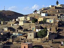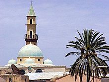


Sitting in the picturesque foothills of northern Eritrea, Keren is the country's second-largest city and regional capital of the surrounding districts. Approximately 146,000 people belonging to various tribes and ethnic groups call the city home. The dominant tribes — Bilen and Tigre — represent over 80 percent of the city's population.
Understand
[edit]History
[edit]The city grew after the establishment of the Eritrean Railway by the Italian colonial powers. It was an important stop before Asmara, from where the line would continue onto the coast at Massawa. Unfortunately, decades of warfare left the railway in disrepair and it has been largely dismantled. There are plans to eventually restore the line.
After Eritrean Independence, Keren entered a transitional development stage. The government, hoping to improve the economic importance of the country's second-largest city, further developed its infrastructure and educational system.
Climate
[edit]| Keren | ||||||||||||||||||||||||||||||||||||||||||||||||||||||||||||
|---|---|---|---|---|---|---|---|---|---|---|---|---|---|---|---|---|---|---|---|---|---|---|---|---|---|---|---|---|---|---|---|---|---|---|---|---|---|---|---|---|---|---|---|---|---|---|---|---|---|---|---|---|---|---|---|---|---|---|---|---|
| Climate chart (explanation) | ||||||||||||||||||||||||||||||||||||||||||||||||||||||||||||
| ||||||||||||||||||||||||||||||||||||||||||||||||||||||||||||
| ||||||||||||||||||||||||||||||||||||||||||||||||||||||||||||
Keren experiences a semi-arid desert climate, with the hottest period being March until June and the coolest from October to February. Weather is sparse throughout the year, except the rainy season that stretches from mid-June to mid-September. The rain can provide a pleasant relief from the hot African sun.
Get in
[edit]- 1 Keren Airfield.
Get around
[edit]See
[edit]The most obvious thing you will see upon entering Keren is its beautiful landscape. Rugged mountains dot the outskirts of the city and create a nice setting to explore the rest of what this city has to offer, such as century-old ruins, bustling markets and Italianate architecture.
- 1 Debre Sina Monastery. Located due east of the city in the surrounding highlands, it is the site of a pilgrimage of thousands of Christian Orthodox believers every year in June. The church sits on a rock overlooking a tiny village, where legend says that local shepherd girls saw visions of the Virgin Mary. The pilgrims have various celebrations of singing, drumming, chanting and dancing.
- Nakfa Mountains. Extremely scenic and remote village.
- 2 St. Michael's Cathedral.
Do
[edit]Buy
[edit]Eat
[edit]
- Injeera and kuluva. Injeera is the Eritrean bread made of a grain called tuff. Kuluva is mutton half cooked. in Keren the Blin community traditionally cooking called kala ካላ.
Drink
[edit]- Local beer.
Sleep
[edit]There are five small lodges or 'pensions' in Keren.
Connect
[edit]Go next
[edit]


