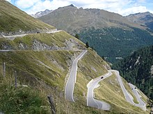
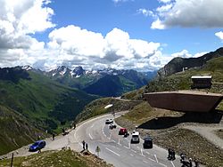
The Timmelsjoch (Italian: Passo del Rombo) mountain pass 2509 m above sea level between the Ötztal and Stubai Alps connects the Ötz Valley (Ötztal) in Tyrol, Austria with the Passei Valley (Passeital) in South Tyrol, Italy. Across the pass goes the Timmelsjoch High Alpine Road, a scenic route that can be enjoyed from a car, motorcycle, bike or on foot, and is generally open from mid-June to mid-October.
Understand
[edit]
The name Timmel derives from the old Romansh word tömbl, meaning "small hill". It doesn't refer to the pass as such but to the round boulders created by glaciers that are visible along the route. The Italian name is newer and translates to the "Pass of Thunder".
The first written records are from 1241 and refer to the pass by the name "Thymels", and in 1320 a path for mules were established across the pass. But the route was already used much earlier by settlers from the Passeier Valley going north, and as a trade route by the Fugger and Welser families. In 1897 the Tyrolean government made a decision to build a real road here, though nothing came of it as other construction projects were preferred.
A few decades later, in 1933, Mussolini had a military road built on the Italian side leading almost up to the pass. Its purpose was to bring troops to the Austrian border for an attack. On the Austrian side a road up the mountain was built between 1955 and 1959. On 15 September 1968 the roads were connected and the current route came into being. Timmelsjoch is Austria's highest road border crossing.
Get in
[edit]By car
[edit]From Austria (Tyrol)
[edit]Exit the Inntal Autobahn A12 (between Innsbruck and Feldkirch) at exit number 123 Ötztal. Then drive along the Ötztalstrasse B186 through the Ötztal to the ski resort of Sölden and on to Obergurgl. Here the high alpine route begins, and it's generally open between mid-June and mid-October during daytime (7 am-8 pm). The toll which you will pay here is valid for both the Austrian and Italian side. The 60 km drive from the motorway will take a little less than one hour in normal traffic.
From Italy (South Tyrol)
[edit]From Merano or Sterzing (across the Jaufenpass/Passo Giovo), take the ss44 to St. Leonhard in Passeier. From there, the ss44bis for 30 km (about half an hour) to the pass. This is a paved but narrow road with tight hairpin curves and tunnels without lamps.
By bus
[edit]When the high alpine route is open, the Timmelbus service connects Obergurgl on the Austrian side with Moos on the Italian. There are bus connections to Obergurgl by Verkehrsverbund Tirol[dead link] (e.g. regional bus 8352 from Ötztal) and to Moos (e.g. bus 240 from Merano) by Südtirol Mobil.
By bike
[edit]Coming from Ötztal, you can take the Ötztal mountainbike trail instead. It leads from the town's railway station to Sölden and on to the Karlsruher Hütte above Obergurgl. Nevertheless from here on, you will ride on the heavily trafficked highway. Due to the road conditions, crossing the pass on bike from Austria to Italy is safer than the other way around.
By foot
[edit]The hiking route follows the E5 European long distance path. It leads from Zwieselstein over the Urweg Timmelstal (an old smuggler's path) up the Timmel valley to the Timmelsjoch. Then through the Passeier Timmelstal past the Hochfirst inn, the village of Rabenstein (Italian: Corvara) and to Moos in Passeier (Italian: Moso in Passiria). Hiking from Zwieselstein to Moos takes between five and six hours.
Go
[edit]
Opening times and tolls
[edit]The route is usually open to traffic between June and October from 7:00 to 20:00.
As of 2022 some of the toll rates are:
- Cars: one-way €17, return €24
- Motorcycles: one-way €15, return €21
- Other vehicles: one-way €28
The Austrian part of the route can be driven by all kinds of road vehicles. On the other hand the Italian part has limits; vehicles heavier than 8 tons, wider than 2.55 m, higher than 4 m or trailers of any kind are banned there. As the toll booth is on the Austrian side, you can drive up and back down on the Italian side free of charge.
By motorcycle and bike
[edit]If you ride on two wheels, be aware that while the road on the Austrian side is rather wide, in good condition and has a more even altitude profile, the road on the Italian side is considerable narrower, steeper, curvier and with dark tunnels and less visibility.
Timmelsjoch is a popular challenge for road bikers. With an altitude difference of almost 1800 m on about 30 km on the Italian side, the pass is one of the steepest in the Alps. Indeed, each August the pass is part of the Ötztaler Radmaraton, a biking competition where Timmelsjoch is the last challenge before the finish line in Sölden. Given that you'll also share the road with plenty of cars, this is definitely not a leisurely tour in the mountains, if you're looking for that kind of experience, Reschenpass (almost 1000 m lower) to the west is a better alternative.
Should you nevertheless decide to do the itinerary by bike, it's easier to do so from north to south. The gain in altitude is more evenly distributed on the Austrian side where you will pedal uphill and there are also more space on the road for cars to overtake you. As per above, be prepared for a more thrilling route down on the Italian side.
See
[edit]
In addition to the mountain views, there are also some other attractions along the route:
- 1 Steg viewpoint (Hochgurgl). Next to the toll station is a viewpoint with information signs where you can learn about the landscape.
- 2 TOP Mountain Motorcycle Museum Crosspoint. The building with the toll station also hosts a motorcycle museum, also with cars on display.
- 3 Schmuggler (Timmelsbachbrücke). The "smuggler" is a small museum in the form of a cube presenting the life of smugglers going over the pass.
- 4 Pass museum (Timmelsjoch). A museum presenting the history of the way over the pass.
- 5 Telescope (Fernrohr) (Scheibkopf). A building with a big lens focused on the mountains Granatkogel (3304m) and Hohen First (3.403m).
- 6 Garnet (Granat) (Moos in Passeier). Two buildings formed like boulders; one is a museums presenting the geology of the mountains, the other is a viewing platform.
Stay safe
[edit]
Adjust your driving speed according to the conditions and visibility, and don't overestimate your skills (this goes especially for motorcycle drivers). You can't know what may await you around that curve. Also, as per above, the road and driving conditions on the Austrian side are rather different from the Italian side.
Go next
[edit]On the Austrian side, the road will go past the ski resorts of Obergurgl and Sölden, and on to the Autobahn A13. From here you can explore the rest of Tyrol and continue on to Germany, Switzerland or Liechtenstein.
On the Italian side you can continue towards Merano in the south, where the Alpine landscape becomes more and more Mediterranean. Alternatively, head east towards Sterzing, crossing the Jaufenpass (2094 m ASL). In Sterzing there's the A22 motorway leading south to the rest of Italy or north to the Brenner pass (1370 m ASL) and back into Austria.


