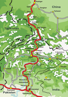
Diamer is a district in Gilgit Division and quite popular with trekkers and mountaineers from all over the world.
Understand
[edit]Diamer is one of the districts of the Gilgit-Baltistan region of Pakistan. It is the district in which the Karakoram Highway, the capital of the district is Chilas. Chilas comes under Gilgit-Baltistan. The weather is hot and dry in the summer and dry and cold in the winter. It can be reached through Karakoram highway and also from the Kaghan valley passing over the Babusar Pass. Chilas have two part
- Uper part city says Shaheen gaon
- Lower part is Paeen gaon

Get in
[edit]By Air
[edit]Chilas Airport is located at Chilas.
By Road
[edit]Chilas can be reached by bus from Islamabad. The drive takes you all the way over the KKH (Karakoram Highway).
Get around
[edit]It's easy to get a taxi or hire a driver for trips outside of the town.
See
[edit]

- Buddhist places
- Chilas River
Do
[edit]- Mountaineering, Trekking and Hiking
- Fishing
- Wildlife
- Biking
- Walking excursions
Buy
[edit]Eat
[edit]Drink
[edit]Sleep
[edit]- Hotel Chilas Inn, Karakoram Highway, Chilas, ☏ +92 5812 50510.
