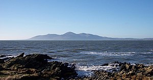
The Mourne Mountains (Irish: na Beanna Boirche) are a Northern Irish mountain range which lie along the south County Down coast near the Republic of Ireland. Colloquially, they are referred to as 'The Mournes'.
Understand
The Mournes have the highest peaks in Northern Ireland and the whole Irish province of Ulster, with Slieve Donard being its tallest at 2,790 ft (850 m). However, many frequent hikers of the Mournes will profess that the walk up to Slieve Donard's peak itself is not the best walk in the whole Range, with many of the other trails offering better views and more varied terrain & scenery.
History
Landscape
Flora and fauna
Climate
Towns
There are two larger towns in the Mournes. These are Newcastle, once a busy seaside resort town, which lies on the foot of Slieve Donard in the north-east of the Mournes and the town of Rostrevor, smaller and nestled away in the south-west offering better access to the western Mournes.
Just out of the park to the west is the town of Newry.
Get in
By car
The easiest way to access the Mournes is by Car. There are various treks starting from many different carparks dotted across the whole Range, where the carpark at the foot of Slieve Donard in Newcastle would likely be the most frequented.
By bus
Buses to Newcastle are not cheap but are available from all across Northern Ireland. At most, depending upon where you're travelling from, you may have to connect in some city once. Typically, from Belfast, a bus to Newcastle costs around £15 for a return ticket.
Once you've arrived in Newcastle, it is then possible to use the dedicated Mourne Rambler bus-service which drives around the Mournes operating a pickup-setdown service whereby you may flag down the bus anywhere on its route and jump off anywhere you wish, not necessarily at any bus stops.
Fees and permits
No fees to enter or stay in the area.
Get around
See
Do
The Mournes are a popular for hikers and climbers.
Buy
Eat
- 1 Herrons Country Fried Chicken, 26 Newcastle St, Kilkeel, ☏ +44 28 4176 5895.
- 2 The Rostrevor Inn, 33-35 Bridge Street, Rostrevor, ☏ +44 28 4173 9911.
- 3 The Downshire Arms Hilltown, Main Street, Hilltown, ☏ +44 28 4063 8899.
Drink
Sleep
Lodging
- 1 The Mourne Lodge, Bog Road, Atticall, ☏ +44 28 4176 5859.
Camping
- 2 Kilbroney Caravan Park, Shore Road, Rostrevor, ☏ +44 28 4173 8134.

