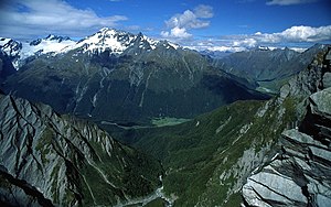
Mount Aspiring National Park lies in the Southern Alps of New Zealand's South Island, in the headwaters of Lake Wanaka. It is part of the UNESCO World Heritage Site of South West New Zealand, or Te Wahipounamu, which includes Fiordland National Park (to the south), Aoraki Mount Cook National Park and Westland National Park (both to the north).
Understand

Mount Aspiring National Park was established in 1964. It is named after the highest mountain in the park, Mount Aspiring/Tititea, which at 3,033 m (9,950 ft) is also the highest mountain in New Zealand outside Aoraki Mount Cook National Park.
In November 2013, contributors to the respected journal Science chose Te Wahipounamu as one of only 78 protected areas around the globe as the most critical for preventing the extinction of mammals, birds and amphibians.
Mount Aspiring National Park was home to the takahe and kakapo, now sadly both extinct in this area, but the rowi, the rarest species of kiwi, lingers on.
History
Landscape
Flora and fauna
Climate
Get in
Fees and permits
Get around
See
- The Gates of Haast
- Waterfalls and temperate rainforest.
Do
- Drive over the Haast Pass
- Climb Mount Aspiring or the other peaks in the area.
- Walk Rees-Dart Track.
Buy
Eat
Drink
Sleep
Lodging
Accommodation is available in the nearest settlements to the park: Haast, Makarora, Glenorchy and, with the most variety and abundance, Wanaka.
Camping
Backcountry
Stay safe
This is about as remote as you can get in New Zealand, without getting off-road. Make sure your fuel tank is full and your vehicle in good working order.
Go next
The nearest settlements to the park are:
