Ilocos Sur is a province in the Ilocos Region of the Philippines.
Cities
[edit]- 1 Vigan - this city was transformed into a commercial, religious, social, and cultural center by Spanish settlers during the 16th century. Today, this provincial capital still has well-maintained cobble-stoned streets and ancestral homes, ensuring its inclusion to the UNESCO World Heritage List.
- Candon
Other destinations
[edit]Understand
[edit]Ilocano is the main language used.
Get in
[edit]By air
[edit]Since February 2017 Vigan's domestic airport (VGN IATA, confusingly called "Mindoro Airport"), located southwest of the city, has re-opened with daily flights to/from Manila, & Basco, Batanes.
The next nearest airport is Laoag International Airport, in the nearby province of Ilocos Norte. The airport caters to both international and domestic flights. The national carrier, Philippines Airlines, has four flights each week to Laoag. A bus trip from the airport to Ilocos Sur would take over an hour.
By land
[edit]An extensive network of roads and highways connect Ilocos Sur to other provinces in the island. Bus trips from the country's capital, Manila, take about seven hours aboard several bus lines like the Philippine Rabbit, Partas, and Dominion.
Get around
[edit]The most common rural mode of transportation would be tricycles and the calesa or traditional horse-drawn carriages. Getting from one municipality to another would require taking a bus, mini-bus, or jeepney. When going short distances, however, it is best to go on foot to experience authentic local adventure.
See
[edit]
- 1 Quirino Skyline/Tirad Pass. designated a National Shrine, this pass was the site of a battle led by a young general named Gregorio del Pilar against revolutionary forces led by hero Emilio Aguinaldo
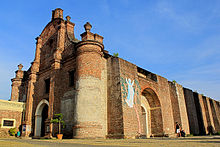
- 2 Santa Maria Church. located in the eponymous town, this is a National Landmark used as a fortress during the Philippine Revolution and one four world heritage listed baroque churches on the Philippines.
- 3 Northern Luzon Heroes Hill National Park. located in Santa and is where a historical marker of heroine Gabriela Silang is located.
- 4 San Esteban and Sulvec Watchtowers. rotund structures used to serve as look-out points for pirates
Do
[edit]Eat
[edit]Drink
[edit]Stay safe
[edit]Go next
[edit]


