Appearance
Tianguá is a city of 76,000 people (2019) in Ceará in Northeast Brazil.
Understand
[edit]
The local economy revolves around agriculture. As in most of the Serra da Ibiapaba, it is very common to plant sugar cane, sweet potato, cashew, strawberry, tomato, pepper, and other fruits and vegetables.
Get in
[edit]Tianguá is about halfway between Teresina and Fortaleza. You might pass through here on your way to Ubajara.
- Guanabara. has many buses passing.
Get around
[edit]See
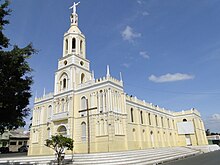
[edit]- Parroquia de Sant'ana Cathedral: Inaugurated in 1882.
- São José Seminar Convent: 1st Seminary in the region. Composed of a mansion, a chapel and an immense green forest . Quiet and silent place, with beautiful gardens and internal patios. Building with architectural structure and stone facade. It was built by the Franciscans in the first half of the 20th century, having long functioned as a boarding school for boys.
- Jaburu Dam: the dam forms a small beach, used by the population for leisure on weekends, receiving hundreds of people from the most different and distant cities in the region. The place offers an excellent option for the practice of sport fishing , with varied species of exotic fish, especially the tucunaretinga . It is 20 km from the city's headquarters, access via the BR-222.
- Santa Rosa Spa (dam): rock formation, with an entrance like a cave. It has a small waterfall, suitable for bathing.
- Cabeça da Nega: rock formation, in which you can find water holes, a lookout from which you can see the city of Viçosa do Ceará. Presence of mills, flour houses and a small chapel, where novenas are held. It is 12 km from the seat of the municipality.
- Cachoeira Cana Verde Waterfall: a waterfall that drops off at a height of 30 m, sheltering a gazebo, providing a complete view of the hinterland. It is 16 km from the municipality, with access via the BR-222 .
- Cachoeira São Gonçalo - Sete Quedas: waterfalls meet, due to the formation of stops, where the path of the water mixes with the fauna and flora. They are 3 km from the city's headquarters, access is via the CE-187.
- Cascade: a waterfall that falls into a natural pool, where it is dammed. It is halfway up the Ibiapaba mountain range. Access is via the BR-222.
- Casarão do Sítio Cajueiro - in Cajueiro, about 9 km from the city of Tianguá. Considered the oldest architectural heritage of Tianguá, it was built in 1880.
- Monument to the Risen Christ: 16-meter statue on top of Chapada da Ibiapaba, on top of Morro da Resurreição, stretch between the Pavão and Morro do Sombrinho stops, on the way up the mountain, and can be viewed from all over the hinterland from the foot of the mountain. The statue is one of the largest artificial works in the north of Ceará, has a support base of 4x4 m, with a base height of 1.60 m, an altitude of 600 m above sea level and a distance of 6 km via BR 222.
Do
[edit]- Paredões do Janeiro: There are corridors originating from rock formations, home to waterfalls and natural spouts. A scene of indescribable beauty. It is 5 km from the seat of the municipality.
- Cachoeira da Floresta Ecological Reserve: Private reserve, with exuberant nature, highlighting the various waterfalls. It has six trails and a "catch-don't-pay". Bathing is allowed. Rappel and zipline activities can be practiced. There are 250 hectares of preserved area (owned by the Serra Grande hotel). It is 12 km from the seat of the municipality. Access in part by BR-222.
- Cachoeira da Mangabeira Trail: at the lookout called "Espelho da Vida", as it has an overview of the mountain range. Access from the lookout to the waterfall is difficult, as it passes between two very narrow walls. There are two waterfalls, with rainforest and humid vegetation. The fauna is quite rich, with wild cats, capuchin monkeys, canaries, and bem-te-vis. It is 5 km from the seat of the municipality.
- Marinema de Baixo Waterfall Trail: there are two trails, a lighter one, suitable for tourists of all ages, and a heavier one, with rope descent. During the course of the trail, you can find waterfalls, encounters of rivers and centenary trees (babaçu, etc.)
- Espia Trail: on the slope of the Serra, characterized by rock formations. It has a waterfall that falls between two stone walls, called "Rocha da Rosa". The trail is 1 km long and 70% of it is flat. In the waterfall on the trail, the water is not a perennial river ; there is a turnout from October to July. It is 5 km from the seat of the municipality.
- Trail of Transhumance: path that connects the mountains to the hinterland, made of stones and used by the first settlers. The trail houses the Pinga waterfall. Along the way you can find several mills and stills . It is 9 km from the headquarters.
- Pinga Trail: has waterfalls that resemble steps. The vegetation is wet forest. The trail is like a kind of funnel. It is 5 km from the seat of the municipality. Access on a side road in good condition.
Events
Events
[edit]The main cultural events in Tianguá are:
- Festivities of Senhora Santana (Jul 16 to 26)
- Feast of St. Francis of Assisi (Oct 4)
- City anniversary (Jul 31)
- Carnival (February/March)
- Festival of Quadrilhas Juninas do Nordeste Festival of squares (June/July)
- Passion of Christ (March/April)

