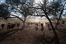
Gobabis is a town of 19,000 people (2011) in Namibia.
Understand
[edit]
Gobabis continues to grow as a town due to goods being transported from the mines of landlocked Botswana to the Namibian port of Walvis Bay, and furthermore from consumer goods being imported into Namibia from Gauteng in South Africa. The transport route is known as the Trans-Kalahari Corridor. Gobabis is connected to the Namibian railway system.
The town hosts a state hospital, a state clinic and a private hospital, banking and shopping facilities. Legare Stadium is located in the town.
Epako is a community about 2 km east of the city centre on the Trans-Kalahari Corridor, separated from it by an unpopulated area of bush. Epako was created before Namibia's independence as a home for black workers. About half of the residents of Gobabis live in Epako. The urban landscape of Epakos ranges from one-storey stone houses with a front garden and fence to corrugated iron houses - the so-called shacks - to the smallest temporary accommodation made of plastic and natural materials. The informal settlement area in the north of Epakos makes up a third of Epako (as of 2013).
History
[edit]The Gobabis district was proclaimed by the German authorities in February 1894 and in June the following year Gobabis was occupied by a German garrison. While the military fort, built in 1896–7, has long since disappeared, one of the few buildings dating back to that era is the field hospital, or Lazarett, which has been declared a national monument.
Get in
[edit]By road
[edit]The B6 (Trans-Kalahari Highway) is the main road between Namibia and Botswana and passes through Gobabis. Gobabis is 200 km (120 mi) down the B6 motorway from Windhoek, and 113 km (70 mi) from the Buitepos border post with Botswana.
Route C30 is a secondary road that runs north west to Gobabis via Steinhausen from the C22 just south of Otjiwarongo. It is a more direct alternative route to the Waterberg Plateau Park in the Otjozondjupa region.
There are Combie (Shared Taxis) from Windhoek.
By train
[edit]At this stage the railway line from Windhoek terminates in Gobabis but it does not carry any passengers. The proposed Trans-Kalahari Railway may pass through this town.
Get around
[edit]See
[edit]- Cattle Country Statue at the southern town entrance, directly on the B6
- Churches: Gobabis is the 'Town of the Churches' in Namibia. 14 historic churches are in town, all major denominations are represented.
Do
[edit]Buy
[edit]- Shoprite, Church Street (city center). A well-stocked supermarket with breakfast bar.
Eat
[edit]Drink
[edit]Sleep
[edit]There are numerous lodges and campsites in and around Gobabis.
- Goba Lodge is on the outskirts of town and overlooks a dam.
- Nossob Safaris provides bunk-style and backpackers' accommodation about 12 km out of town on Route C30.
- Steps Accommodation, Hemanus Landsberg Avenue Nossobville (1.4 miles from the center), ☏ +264-81-2683656. Budget double or Twin room. Garden view. Flat screen TV and a shared kitchen. from 200.
Connect
[edit]Go next
[edit]Witvlei is the next destination on the way to Windhoek.
If you are on your way to Botswana, the next stop is the borderpost at Buitepos.

