
Ad's Path

Ad's Path (Pad van Ad) is a hiking trail south of Leuven in Belgium that passes by a number of sculptures by artist Ad Wouters. Located fairly close to Brussels, it could make for a long outdoor daytrip if you want to get out of the city into the Belgian countryside. You can also travel along the path by bike if you prefer.
Understand
[edit]Ad's Path passes through the forests of Heverleebos and Meerdaalwoud for a total distance of 25 kilometers (shortcuts can reduce this to 16 kilometers). Aside from Wouters' oak wood sculptures, you'll also see two of the oldest trees in the forest and several other worthwhile attractions.
The itinerary described below is based on the description you can find on Ad Wouters' web site[dead link] in Dutch; however, it's not an exact copy. This article is written such that one can either follow the whole route in one go, divide it up into several shorter stretches to enjoy on different days, or jump in by using public transportation. If you're a particularly avid or adventurous hiker, you can even camp at a pair of idyllic but primitive sites near the trail (see below).
Theme
[edit]The theme of the route revolves around the artwork of Ad Wouters, a sculptor whose work touches on issues of ecology and social consciousness. His familiarity with the materials he would later use in his art, such as plaster and wood, comes from his career in construction, which began when he was 13 and culminated in a period working in the restoration of historic buildings. Unfortunately, his fall from a church tower in a work-related accident ended his days in the construction field, but Wouters used his misfortune as an opportunity to launch himself on a new path as an artist, with a preference for use of recycled materials.
On this walk, you'll encounter several of Ad's trademark wooden sculptures. There are more of them in Leuven, as well as a statue of Saint Michael, which appears to be made of metal but is actually hollow polyester (the material also used to make kayaks) coated with bronze (a cost-reduction measure). Wouters prefers to display his sculptures outdoors so as to maximize opportunities for the general public to enjoy his work.
Directional signs
[edit]
The tourist office of Flemish Brabant has created a network of numbered directional signs all across Zuid-Dijleland (Southern Dyle River Area). These signs are somewhat useful as landmarks for those taking Ad's Path, but they don't direct you along the itinerary from start to finish. And, often the arrows pointing to each numbered sign don't tell you anything more than which path to take (or even which path not to take). For best results, carry a map such as the one included in this article, or download the GPX and load it into a GPS device.
Using this article's dynamic map
[edit]To show these numbered nodes on the dynamic map in this article, you need to manually switch on the Hiking layer using the icon in the top right of the map. Ad's Path itself (PA, Pad van Ad) is the dark blue loop in the centre of the map (but make sure not to confuse it with other trails which are rendered on the map in the same colour), with smaller auxiliary routes represented as orange lines. The "official" shortcuts, rendered in magenta, are marked with PAB ("shortcut" translates to binnenweg in Dutch).
To see where public buses travel, you can switch layers to Traffic line network. For a softer background layer, try the relief map. Ctrl-Click on the names of the bus stops will present you with real time information about which buses are arriving shortly. For TEC Bus 18, there is one page for stops in both directions; for the stops of De Lijn, there are two pages, one for each direction. So, it's important to make sure you are looking up the time for the bus going in the right direction.
Prepare
[edit]Ad's Path leads you through the forests south of Leuven in Belgium, with lots of interesting things to see and do nearby. There are many shortcuts and auxiliary paths that cut across and fan outward from the main loop, and the whole network can be confusing to navigate, so make sure you do have some printed or electronic map to refer to. Whether it be the main path or a shortcut, all the elements of the network are in decent repair and there are only a few low hills to contend with, so light hiking shoes should suffice. However, the route is long and it can occasionally be a little wet underfoot, so if you're not an avid hiker or don't have a lot of time on your hands, bicycling is another possibility.
Get in
[edit]
Leuven, the nearest city, can be easily accessed by train, bus or car. If you're flying, Brussels Airport (BRU IATA) is where you'll want to land: it's just 13 minutes away from Leuven by local train. See Leuven#Get in for more details.
By bus from Leuven
[edit]There are two public transport services in this part of Belgium — the Flanders Region's De Lijn and the TEC, run by the Walloon Regional Transport Company (Société régionale wallonne du transport). Both can be used to get to Ad's Path.
It's always possible to buy a bus ticket directly from the driver, but if you're planning to use the bus more regularly or as a group, it's advisable to get a card to get a lower fare. For De Lijn you have to go to De Lijnwinkel (shop) at the Leuven's railway station or to other participating retailers. Also, if you'll be taking multiple buses, keep in mind that tickets from one transit system are not valid on the other.
De Lijn
[edit]Bus 1 or 2
[edit]Hikers can get a head start by taking Bus 1 or 2 to the corner of Naamsesteenweg and Leopold III-laan. There is a SPAR shop near this stop, in case you need food or drinks. The buses run very frequently, from Leuven station's 1 Platform 6 (real-time schedule[dead link]). Continue for about 500m on Naamsesteenweg, then turn right and pass by 2 Brasserie 500 restaurant. After you pass under the motorway viaduct, you'll see the entrance to the Arboretum on your right hand side.
Bus 5
[edit]In terms of public transit, Bus 5 (Wakkerzeel—Wijgmaal—Leuven—Haasrode—Blanden—Vaalbeek) is far from the best option for visitors to Ad's Path. You have to get on the bus at 3 Platform 3 of Leuven Station (real-time schedule) and take it to almost the last stop: 4 Brainestraat bus stop in Vaalbeek, just after crossing the express road for the second time. But, since this bus also passes through Heverlee, Haasrode and Blanden, it takes a good while to get to Vaalbeek — and if you're arriving after 18:30, you're out of luck entirely, as it won't go further than Heverlee then. On the other hand, the stop is near one of the best (and hardest-to-photograph) sculptures on the trail: after you get off the bus, make your next left and there you are at Prosperdreef.
Bus 337
[edit]If you're following Ad's Path in the direction this itinerary is described, you can take Bus 337 (Leuven—Wavre) back home from 5 Don Bosco bus stop, 6 Zoete Waters bus stop or 7 Sint-Joris-Weert Church. Usually there is a bus every hour, but on Sundays this drops down to every two hours. Buses leave from 8 Platform 8 of Leuven Station (real-time schedule).
TEC — Bus 18
[edit]TEC Bus 18 passes over Naamsesteenweg through Heverlee and Blanden. It passes around Leuven on the bypass expressway rather than taking city streets, also omitting the stops at Tiensepoort and Parkpoort. This route makes for a faster trip. Bus 18 departs from Leuven Station's 9 Platform 14 (Leuven Station platform 14), and there are a few different stops at which you can get off to access Ad's Path:
- De Jacht bus stop, at the corner of Naamsesteenweg and Huttelaan just before the E40 motorway overpass. If you're going to do all of Ad's Path in one go, following the itinerary as described on this article, this is where you'll want to get off.
- However, if you're only planning to do a portion of Ad's Path, you can also take Bus 18 further south, to 10 Weerten Dreef bus stop, and follow the route back to the arboretum — this reduces the total distance you'll walk on Ad's Path to 9-14 kilometers.
- Better still, you can also get off at the next stop after Weertse Dreef, 11 Sint-Theresiakapel bus stops, from which you can see the 1 ecoduct that local wildlife uses to safely cross the road, as well as two additional statues which you'll see in the woods on your left. From Sint-Theresiakapel, you'll backtrack a little bit along Naamsesteenweg, cross the road, and proceed to Walendreef. The length of your hike back to the Arboretum from there is 11-18 kilometers.
A word of warning for Sunday visitors: on that day, Bus 18 departs Leuven station only once every three hours (9:08, 12:08 and 15:08), so plan your itinerary carefully or choose another method of arrival.
In 2015 Ad added 2 more statues along Naamsesteenweg. These 2 are visible when taking bus 18. One is a giant Equisetum arvense, just before leaving Heverlee. Start looking for it on your right hand side, a little after passing under the E40 highway bridge. The other is a giant Common kestrel, which became the mascotte for the newly developed welcome zone, where you also find a large parking and as of June 2018 also sanitary amenities.
By train
[edit]If arriving by train rather than bus, you'll find that you've got a longer walk to the start of the path, but it's a fairly convenient and interesting option for those who've already taken Belgian Rail to get to Leuven, Wavre, Ottignies or Louvain-la-Neuve. Trains leave from 12 Platform D of Leuven Station (real-time schedule); you'll want to get off at either 13 Oud-Heverlee Station or 14 Sint-Joris-Weert Station.
Go
[edit]This itinerary begins on Naamsesteenweg, where the E40 motorway crosses over the road. Heading south, you'll see a path that begins on your right just after the viaduct. Turn there, then bear left at the fork in the trail that you'll soon come to. This will take you into the Heverlee Arboretum[dead link], which in addition to being a pleasant place to stroll in its own right, is also the site of the first three statues of Ad's Path.
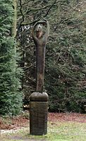 The Director
 Ignatius
 Neanderthal

.jpg)

The Director
[edit]Ad's Path per se starts at directional sign #66 inside the arboretum. Start by following toward #64, but instead make your next left and continue onwards down the shortcut until you see 1 The Director on your right.
Ignatius
[edit]Continue following the same path; soon it will veer to the right and you'll come to a fork in the road. Hang a left, then make an immediate right. The path you're on now ends at a "T" intersection where you'll find three information panels at your right hand side. Take a closer look between the trees to your left and you'll also see the friendly owl 2 Ignatius — it's easy to miss it, if you don't know it's there.
Neanderthal
[edit]Turn left at Ignatius, then left again when the path splits, right at the next split, then keep going straight until you see more numbered directional signs. Make a right toward #65 and continue until you arrive at 3 Neanderthal.
Equisetum arvense
[edit]In 2015 a new cycle path was constructed parallel to the E40 highway, which meant traffic on Naamsesteenweg was deviated. This gave Ad the possibility to create another statue. It depicts a common horsetail. Passing by it only makes sense when following the path by bicycle. Continuing straight on Prosperdreef is the better option when on foot. If you want to see it, you need to make a left turn onto Parnassusbergdreef until you reach Naamsesteenweg, then turn right. To get back to Prosperdreef, continue south on Naamsesteenweg, until you reach Brainestraat. Continue until you reach the T-crossing with Onze-Lieve-Vrouwstraat and go right. The next street on your left is Prosperdreef.
Bat
[edit]It's a bit of a long walk to the next sculpture: continuing toward #65, you'll make a turn toward #603 until you come to a somewhat confusing seven-cornered intersection. Follow Prosperdreef (slightly to the left, the one with the barrier), crossing Onze-Lieve-Vrouwstraat 1.5 kilometers further in Vaalbeek. (Bus 5 passes here; the nearest stop, Brainestraat, is on your left.) Keep going straight on Prosperdreef and on your right you'll see the 4 Bat.
Common kestrel
[edit]Continue to the south, at the next fork, go left into Diewegstraat. Ad started working on a large bird statue in 2015. In 2016 it was moved out of the way, because a new welcome zone is developed here. Now it's back in its final location, near to a parking lot (and soon a large tower with sanitary accomodations). an overview
 Horse tail
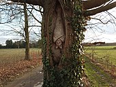 Bat
Bat Owl
Owl Woodpecker

_4.jpg)


Nico and Owl
[edit]After 800m of walking between the meadows, you arrive at #119. Follow the cycle path on Naamsesteenweg to where you can cross.
A little bit south of the crossing, along the side of the road, you can also find 5 Nico, a memorial Wouters created for a man who died in a motorcycle accident here in 2009 at the age of only 22. Although it's not part of the official route, it makes for an easy and quick diversion. You'll notice that the sober style of Nico is in sharp contrast to the lighthearted, whimsical aesthetic of the sculptures on the main trail. It's important to keep in mind that Naamsesteenweg is a high-traffic thoroughfare with no sidewalk, and it doesn't really lend itself well to casual wandering. If you do decide to go and have a look at Nico, it's far better to follow the cycle path than to walk along Naamsesteenweg itself.
Continue southeastward along Margrietendreef (backtracking from Nico if necessary), and be careful when crossing the busy Naamsesteenweg. After 1.3 kilometers, Schoonzichtdreef forks to the left. Here you'll come to directional sign #114, and a choice: a shortcut takes you further along Margrietendreef to Weertse Dreef, then right on Godendreef to Walendreef, saving you 2.5 kilometers of walking at the cost of skipping over the next sculpture listed here. For the full route, turn left at #114, then right at #115 (i.e. not toward #116 or #72). Soon you'll pass the 6 Owl, sitting in his niche inside the Y-shaped trunk of a large tree.
Woodpecker and The Bird Whistling for Cheer Joy
[edit]Continue south as far as Weertse Dreef, then make a right and a quick left. Proceed for 200 meters, then make another left. At Walendreef make a right and keep going for 1.2 kilometers. On your right, you'll encounter two sculptures in quick succession: the 7 Woodpecker and 8 The Bird Whistling for Cheer Joy.
Onward to Coprinus
[edit]There are quite a number of different routes you can take between The Bird Whistling for Cheer Joy and Coprinus: the main route takes you past all the highlights enumerated below, but there are many shortcuts as well to help you shave time and distance off this lengthy stretch of trail.
The first shortcut begins not long after The Bird Whistling..., where instead of turning off Walendreef to Dikke-Eikdreef as in the main route, you continue further to Eleonorendreef, skipping over the next point of interest but saving 1.5 kilometers of distance. However, to follow the full route, you should indeed turn left at Dikke-Eikdreef, continuing across Godendreef until you arrive at Meerdaalwoud's 9 Oldest Oak Tree, which dates all the way back to 1680.
The oak tree stands at the "T" intersection of Dikke-Eikdreef and Kanselierdreef. Continuing on the main route, you'll turn right onto Kanselierdreef and right again on Eleonorendreef (if you took the shortcut mentioned above, this is where you'll end up). Keep going as far as directional sign #113, then hang a left on Weertse Dreef and head toward Naamsesteenweg.
If you've had enough sightseeing for now and would rather pick the itinerary up again later, you can head under the pedestrian viaduct that passes over Naamsesteenweg. Weerten Dreef bus stop, where you can catch TEC Bus 18, is there. The last bus toward Leuven leaves at 19:22 on weekdays and 17:35 on the weekend. Otherwise, continue over the bridge toward directional sign #112 and then #121. When you get to the corner of Prosperdreef, you'll see a high fence: this is the perimeter of a military facility. Turn right toward the fence and then make a quick left, keeping the military facility on your right. After about 600 meters, make another left on Grezstraat. Cross back over Weertse Dreef, then make your next left near the old picnic table you see on the right. Here you have the 10 Oldest Beech Tree in Meerdaalwoud, planted around 1800.
Now backtrack to Grezstraat and Weertse Dreef. Just before reaching it go left into the footpath which leads you straight to August Denteneerpad, where you'll hang a left. At the six-corner intersection of Denteneerpad, Platanendreef, Jamaïcadreef, and Kleine Dreef, you have the choice of making another shortcut. If you make your second right (at "two o'clock", or toward directional sign #108), you'll pass through the 11 Everzwijnbad Playground, saving you 2 kilometers. This charming, rustic playground hidden in the woods features climbing poles and bridges as well as a giant-sized xylophone and pick-up-sticks game — a perfect place to stop for a rest if you've taken the kids along. On the other side of Everzwijnbad is Herculesdreef, where you can pick up the trail again. Otherwise, to follow the full route take Jamaïcadreef due south as far as Walendreef, then turn right. After about 500 meters, you'll find the three-stalked 12 Coprinus.
 Baloo
Baloo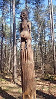 Bosprotter
 Drowning


Baloo
[edit]From Coprinus, make a sharp right on Herculesdreef and keep going past August Denteneerpad until you see a rope course in the trees — you've now reached the 13 De Kluis scout camp. Turn left past the main building and cross over the parking lot at right. You'll see another building with some garbage containers alongside it; go left there (you're on Polderstraat now) and a bit further you'll see the next Ad Wouters sculpture on the path, 14 Baloo.
Bosprotter
[edit]You're now on the corner of Polderstraat and a side trail. Turn right on that side trail, then right again at the "T" intersection where it ends. After 100 meters or so, you'll come to a four-way intersection where you'll turn left. Now turn right at the building you see in front of you, then make your first left — you're back on Herculesdreef now, on the other side of Everzwijnbad Playground. After about 200 meters, between several other totem poles, you'll encounter the fat-bellied 15 Bosprotter.
Along Herculesdreef to Minnebron and Drowning
[edit]
Keep going northward on Herculesdreef. If nature is calling, you can turn left on Weertse Dreef and find a 2 sanitary facility at left with toilets and potable water. There is also a parking lot and a welcome zone here, so you could also start from here. This is also the starting point if you decided to come by train or by using bus 337.
However, the main route heads further north still.
You'll come to a fenced-off area where it's permitted to unleash your dog. Immediately afterward, there's a path on your right that leads through what was once a military area, but is now a nature reserve. The path is paved with concrete, making it accessible to wheelchairs, it's a long alley between the trees. If you want to take a rest, here is a good place.
It's still a straight shot northward up Herculesdreef. Directional sign #19 is straight ahead; keep going past it toward #18 and then #16. On your right, you'll see De Steenberg campground, which you can read more about below. Further north still, at the corner of Witte Bomendreef, you'll see two landmarks: on your right, the 16 Our Lady of Steenbergen Chapel (Onze-Lieve-Vrouw van Steenbergenkapel), a charming Baroque- and Rococo-style country church dating back over 350 years. On your left is 3 Minnebron, a natural spring with drinkable water. A bit further along, on the shore of Geertsvijver, you'll find a creation from the spring of 2014 whose style is completely different from any other sculpture on the trail. Instead of being carved from oak wood, 17 Drowning is a figure of a drowning man that's made of a metal wire mesh filled with litter, symbolizing how we all but drown in the solid waste we produce.
Don Bosco
[edit]After Drowning comes the opportunity to take another shortcut, the last on the itinerary: if you continue northward across Maurits-Noëstraat, the name of the road you're on changes to Parnassusbergdreef and you can continue straight as far as directional sign #12 at the corner of Sint-Annastraat. The shortcut cuts 1.5 kilometers off the route at the price of missing out on the next sculpture. Otherwise, you backtrack a little bit from Drowning and turn right on the path that follows the south shore of De Zoete Waters pond. It will bend sharply to the right, still following the shore, and you'll end up walking northward on a narrow spit of land between De Zoete Waters and Huisvijver ponds toward Maurits-Noëstraat.
If you're hungry or in the mood to take a break from walking, now would be a good time to divert from the path and head left, where there are 4 several restaurants and a place to get french fries, as well as 18 Zoet Waterpark, with play equipment for kids as well as mini-golf (for a fee). As well, if you make your first left before Maurits-Noëstraat coming from Drowning, you'll come to another restaurant, 5 Het Spaans Dak, nearby which it may be possible to rent a rowboat to take on the pond (though in summer 2014 it was closed due to an algae bloom and from 2015 to 2017 they were renovating).
Continuing on the itinerary itself, a little to your left across Maurits-Noëstraat you'll see the continuation of the path, now paved in concrete. Keep going toward directional sign #14, and follow the path as it veers to the right and climbs a hill. At the crest of the hill, turn left through the parking lots of the Stedelijke Sportcomplex football stadium, toward Waversebaan. Cross the road and you'll find yourself in the entranceway of Don Bosco institute, which ends in a cul-de-sac where you'll find 19 Don Bosco on your right, directly in front of the Institute building.
Back to the start
[edit]Turn right after Don Bosco toward the playground, then backtrack to Waversebaan via Don Boscolaan and the driveway you took to get here. At Waversebaan, turn left, then make a slight right on Sint-Annastraat, continuing past directional signs #12, #602, #601 and #603 to #65 via Parnassusbergdreef, Karrendreef, and Damendreef. Soon you'll find yourself back at the arboretum. Follow Grezweg back to the starting point.
Sleep
[edit]There's a multitude of hotels, hostels and other accommodations in Leuven and other nearby towns. But, if you're dead-set on sleeping in close proximity to Ad's Path (and especially if you plan to break the hike up into two or more days), you can spend the night at your choice of two primitive campsites:
- 1 De Steenberg campground boasts an idyllic setting about halfway down the trail. Campsites are available free of charge on a first-come-first-served basis, but it bears emphasizing that the water at the pump is not potable. There are two nearby sources of potable water — Minnebron spring as well as a modern sanitary facility — each located about 1.5 kilometers from the campground, in opposite directions.
- 2 Het Spoor/La Trace campground is a brand-new facility established in the summer of 2014, located about a kilometer south of Ad's Path. To get there by bus, take TEC Bus 18 to Sint-Theresiakapel stop; it's a relatively easy 2-kilometer walk from there via Naamsesteenweg, Warandedreef, and several footpaths.
Stay safe
[edit]- Weertse Dreef, De Maurits-Noëstraat, Waversebaan, and (especially) Naamsesteenweg are all heavily-trafficked roads that you'll have to walk across at one time or another over the course of the itinerary. Be very careful when doing so.
- Lyme disease and TBE (tick-borne meningoencephalitis) are both very serious and debilitating infectious diseases spread by ticks, which are present in the forests of Heverleebos and Meerdaalwoud. In the evening after your walk, it is very important to check your body for ticks. See our article on Ticks for information on how to check for ticks, what to do if you find a tick, and how to prevent yourself from being bitten in the first place.
Go next
[edit]Liked what you saw on Ad's Path and hungry for more? You'll be happy to know that there are a few more sculptures by Ad Wouters scattered around the area.
 The Prophet
 Saint Michael
 Pootefretter


- Closer to Ad's Path, you'll find:
- 1 Pootefretter, a bronze statue at the entrance of the school in Haasrode of a rather elfin-looking old man eating a carrot. Pootefretters is the nickname locals have for residents of Haasrode, taken from a story dating from years past about a failure of the local potato crop that forced the villagers to subsist on carrots.
- 2 Voor hen van toen ("For Them, for What They Did Back Then") can be found alongside the old railroad track in Doode Bemde, in Neerijse on the border with Sint-Joris-Weert. It's a commemorative memorial that serves as a token of gratitude to the volunteers who have helped maintain this large natural reserve over the years.
- From Ad's Path, head over to Leopold III-laan bus stop and take De Lijn Bus 1 or 2 into Leuven to see:
- 3 The Prophet, an impressive figure fashioned out of a dead tree, of a bearded man with sawed-off branches turned into outstretched arms. It's located in Sint-Donatus Park.
- In the conservatory of the charming Kruidtuin Botanical Garden is the flower, 4 Arum. Ad is also exposing some work which is usually hidden away until October 2015 in Kruidtuin.
- A sculpture at Sint-Michielskerk on Naamsestraat depicts the church's namesake, 5 Saint Michael the Archangel, having just broken his sword after slaying the dragon in the famous scene from the Book of Revelation. The statue looks as if it's made of plaster, but uniquely, it's actually polyester coated with bronze paint, then varnished in order to prevent oxidation and keep the bronze colour very light.