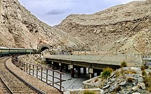
The Bolan Pass is in Pakistan. It is one of two main routes from Afghanistan into the Indian subcontinent, along with the Khyber Pass further north. As of 2012, it was only open to locals and aid workers. The ethnic groups and dangers are similar to those in the Khyber Pass.
Understand
[edit]
The Bolan Pass is a mountain pass through the Toba Kakar range of Balochistan province in western Pakistan, 120 km (75 mi) from the Afghanistan border. The pass is an 89-km (55-mi) stretch of the Bolan River valley from Rindli in the south to Darwāza near Kolpur in the north. It is made up of a number of narrow gorges and stretches. It connects Sibi with Quetta by road and by railway.
This was the route for a British invasion of Afghanistan during the First Anglo-Afghan War in 1839. Later, there were three Anglo-Marri wars (1840, 1880 and 1917) pitting the tribesmen of the area against the Raj.
The pass links Quetta to the central areas of Pakistan. From Quetta, Kandahar in Afghanistan is reasonably close. There are small towns in between.
Get in
[edit]Get around
[edit]See
[edit]The important archaeological site Mehrgarh is near the south end of the pass.
Do
[edit]Buy
[edit]Eat
[edit]Drink
[edit]Sleep
[edit]Connect
[edit]Stay safe
[edit]This area, as of mid-2012, is definitely not safe. Even with armed guards, travel is not recommended.

