
Chino

Chino (Japanese: 茅野) is a city in Nagano prefecture.
Understand
[edit]While the western part of the city is a downtown and has some museums, eastern Chino is a mountainous area. In that area called Tateshina (蓼科), there is the North Yatsugatake Mountains (北八ヶ岳), and Oku-Tateshina Onsenkyō (奥蓼科温泉郷), which is the area of hidden hot springs. The moss in Yatsugatake Mountains is famous for its deep green color among the Japanese people, and once you enter the forest your vision will be filled with green.
Climate
[edit]| Chino (Japan) | ||||||||||||||||||||||||||||||||||||||||||||||||||||||||||||
|---|---|---|---|---|---|---|---|---|---|---|---|---|---|---|---|---|---|---|---|---|---|---|---|---|---|---|---|---|---|---|---|---|---|---|---|---|---|---|---|---|---|---|---|---|---|---|---|---|---|---|---|---|---|---|---|---|---|---|---|---|
| Climate chart (explanation) | ||||||||||||||||||||||||||||||||||||||||||||||||||||||||||||
| ||||||||||||||||||||||||||||||||||||||||||||||||||||||||||||
| ||||||||||||||||||||||||||||||||||||||||||||||||||||||||||||
Geography
[edit]Chino City is located at the edge of the Yatsugatake mountains (八ヶ岳連峰 Yatsugatake-renpō) and is a good starting point for mountain climbing. Mt. Tateshina, Mt. Kirigamine, and Mt. Kuruma are famous, and the most convenient way to reach trailheads like Mugikusa Hutte (麦草ヒュッテ) and Shirakoma Pond (白駒池) parking lot is to follow the Fairy Tale Route (メルヘン街道) from the city area. Mt. Shirakoma Pond, a 15-minute walk from the Shirakoma Pond parking lot, is recommended for those who have few experiences to climb before, as it takes 40 minutes to walk around the pond and the path is made by two to four wooden planks. The water in the pond is very clear, and the moss on the rocks and bold roots are very beautiful. Signposts along the way introduce several typical mosses, and you can enjoy them even if you have no knowledge of them. Seitai-sō (青苔荘, which means a house of the deep-green moss) on the way has a store, and you can lodge or camp here though you will need to walk between the parking lot and the house to carry your luggage.
Tourist information site
[edit]The local tourist association has a multilingual guide site.
Get in
[edit]By train
[edit]The JR Chuo Line (中央本線 Chūō Honsen) runs through the city, and either Chino Station (茅野駅) or Aoyagi Station (青柳駅) is available. The Chuo Line runs from Tokyo in the east to this city via Hachioji, Otsuki, Kofu, and Kobuchizawa, and then through Suwa, Okaya, Shiojiri and Kisofukushima (Japanese version), ending at Nakatsugawa.
By bus
[edit]Alpico Transportation (アルピコ交通 Arupiko kōtsū) and JR bus Kantō (JRバス関東) are available. The bus routes around this area operated by Alpico Transportation is called Suwa bus (諏訪バス), which also has express buses from Shinjuku, Kyoto, and Umeda.
Get around
[edit]By train
[edit]With only Chino and Aoyanagi stations in the city, rail service would be inconvenient as a means of transportation.
By bus
[edit]
The route network of Alpico Transportation is extensive. In the Alpico Transportation routes, the buses around this area are called Suwa Buses.
See
[edit] Lake Tateshina
 Lake Shirakaba
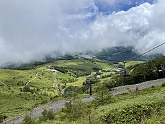 The view from Kurumayama
 Uehara Castle Ruins
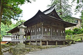 Zengū of Suwa Grand Shrine
 Tateshina Great Falls


The lakes in Chino are a wonderful summer retreat mainly for people living in the Kanto region, but it may not be interesting to some true-nature lovers because of recent development. If you prefer nature with little development, go further away. Oku-Tateshina (奥蓼科, which means deep in the Tateshina) area is almost perfectly natural, with the only traces of man being the guideposts and footprints. Ameike Pond (雨池) is the second biggest pond around this area, and the view of the Mishaka Pond (御射鹿池) is wonderful, though it is small.
Kurumayama mountain (車山) also has a stunning view with Lake Shirakaba (白樺湖) and the city area of Chino. Kurumayama on foot, but there is also a ropeway.
- 1 Mishaka Pond (御射鹿池), Toyohira, Chino city.

Museums
[edit]There are some museums in the urban area.
- 2 Hōrō Art Museum (放浪美術館). 09:30-18:00. More than 170 works by the famous wandering artist, Kiyoshi Yamashita.
- 3 Chino City Museum of Art (茅野市美術館). 09:00-19:00.
Do
[edit]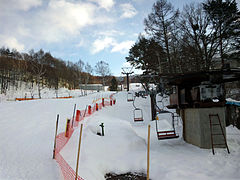 Shirakaba Ski Resort

Eat
[edit]Chino have variety of restaurants such as Italian, French, Japanese, and so on. But you can't afford not to eat Shinshū soba (信州そば). This is registered as an Intangible Folk Cultural Property of Nagano Prefecture. You may will find many soba restaurants in Chino, and some of them provide Jūwari soba (十割蕎麦, soba made with only buckwheat flour).
Sleep
[edit]There are several hot spring inns in Oku-tateshina Onsenkyō. It is also possible to just enjoy the hot springs without staying overnight.
Stay safe
[edit]Connect
[edit]Facilities operated by the City of Chino are equipped with free Wi-Fi.
Go next
[edit]- Suwa — The town just next to Chino, which has a beautiful lake and a castle
- Ueda — Ueda Castle
- Okaya —
- Shiojiri —
- Matsumoto — famous for the castle designated a National Treasure of Japan